Groundwater Bulletins
Groundwater Bulletins is a series of 201 reports published from 1950 to 1965. They have all been digitized and published below. Bulletins typically present the results of long-term or extensive investigations, often covering a large region or county. Topics include well records, geology and groundwater resources, but are not limited to groundwater themes. All are out of print but they've been scanned & published here electronically. To find a specific Bulletin on this web page, click inside the Search Table box and enter a keyword or phrase.
Accessibility note: Many of these reports were scanned from hard copy originals and are not fully accessible for users of certain assistive technologies. However, if you need assistance with a specific report, please contact the Webmaster and we will provide a text-based copy or otherwise make every effort to help you.
Bulletins listed by Number:
| Number | Report Title | Published |
|---|---|---|
| 5001 | Geology and Ground-Water Resources of the Houston District, Texas | 1950 |
| 5003 | Geology and Ground-Water Resources of Walker County, Texas | 1950 |
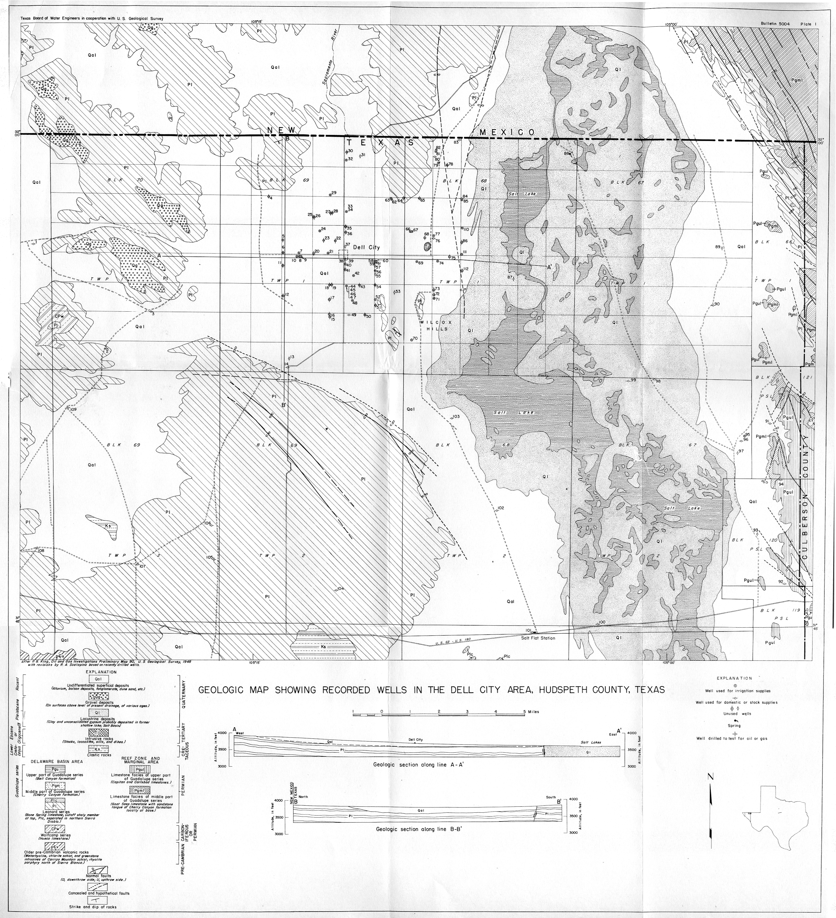
| 5004 | Development of Ground Water for Irrigation in the Dell City Area, Hudspeth County, Texas Geologic Map Showing Recorded Wells in the Dell City Area, Hudspeth County, Texas |
1950 |
| 5101 | Water Supply of the Houston Gulf Coast Region | 1951 |
| 5102 | Summary of the Development of Ground Water for Irrigation in the Lobo Flats Area, Culberson and Jeff Davis Counties, Texas | 1951 |
| 5103 | Ground-Water Resources of Parker County, Texas | 1951 |
| 5104 | Development of Wells for Irrigation and Fluctuation of Water Levels in the High Plains of Texas to January 1951 | 1951 |
| 5201 | The Houston District, Texas, Pumpage and Decline of Artesian Pressure During 1950-51 | 1952 |
| 5202 | Summary of Ground-Water Development in the Pecos Area, Reeves and Ward Counties, Texas 1947-51 | 1952 |
| 5203 | Winter Garden District Dimmit and Zavala Counties and Eastern Maverick County, Texas | 1952 |
| 5204 | Ground-Water Resources in the Vicinity of Kenmore Farms, Kendall County, Texas | 1952 |
| 5205 | Texas Index of Surface Water Records 1882-1951 Discharge, Sediment, Chemical Quality, Water Temperature | 1952 |
| 5206 | Results of Artificial Recharge of the Ground-Water Reservoir at El Paso, Texas | 1952 |
| 5207 | Geology and Ground-Water Resources of Lynn County, Texas | 1952 |
| 5208 | Water Resources of Waller County, Texas | 1952 |
| 5209 | Groundwater Resources of Starr County, Texas | 1952 |
| 5210 | Ground-Water Resources of Ector County, Texas | 1952 |
| 5301 | Ground-Water Resources of the Odell Sand Hills Wilbarger County, Texas | 1953 |
| 5302 | Records of Water-Level Measurements in Hale County, Texas 1910-1953 | 1953 |
| 5303 | Records of Water-Level Measurements in Lubbock County, Texas 1936-1953 | 1953 |
| 5304 | Records of Water-Level Measurements in Floyd County, Texas 1913-1953 | 1953 |
| 5305 | Records of Water-Level Measurements in Deaf Smith County, Texas 1914-1953 | 1953 |
| 5306 | Records of Water-Level Measurements in Lamb County, Texas, 1914-1953 | 1953 |
| 5307 | Records of Water-level Measurements in Swisher County, Texas 1914-1953 | 1953 |
| 5401 | Pumpage of Ground Water and Decline of Artesian Pressure in the Houston District, Texas, During 1951 and 1952 | 1954 |
| 5402 | Summary of Ground-Water Development in the Southern High Plains, Texas | 1954 |
| 5403 | Ground-Water Resources of Cameron County, Texas | 1954 |
| 5404 | Records of Water-Level Measurements in Dallam, Hansford, Hartley, Hutchinson, Moore, Ochiltree, and Sherman Counties, Texas | 1954 |
| 5405 | Records of Water-Level Measurements in Martin County, Texas 1936-1953 | 1954 |
| 5406 | Records of Water-Level Measurements in Bailey, Briscoe, Castro, Parmer, Potter, and Randall Counties, Texas | 1954 |
| 5407 | Records of Water-Level Measurements in Cochran, Crosby, Gaines, Hockley, Lynn, and Terry Counties, Texas | 1954 |
| 5408 | Records of Water-Level Measurements in Loving and Ward Counties, Texas | 1954 |
| 5409 | Salt Water and its Relation to Fresh Ground Water in Harris County, Texas | 1954 |
| 5410 | Ground-Water Development in the Southern High Plains of Texas, 1953 | 1954 |
| 5411 | Groundwater Resources of Tom Green County, Texas | 1954 |
| 5412 | Ground-Water Resources of the San Antonio Area, Texas | 1954 |
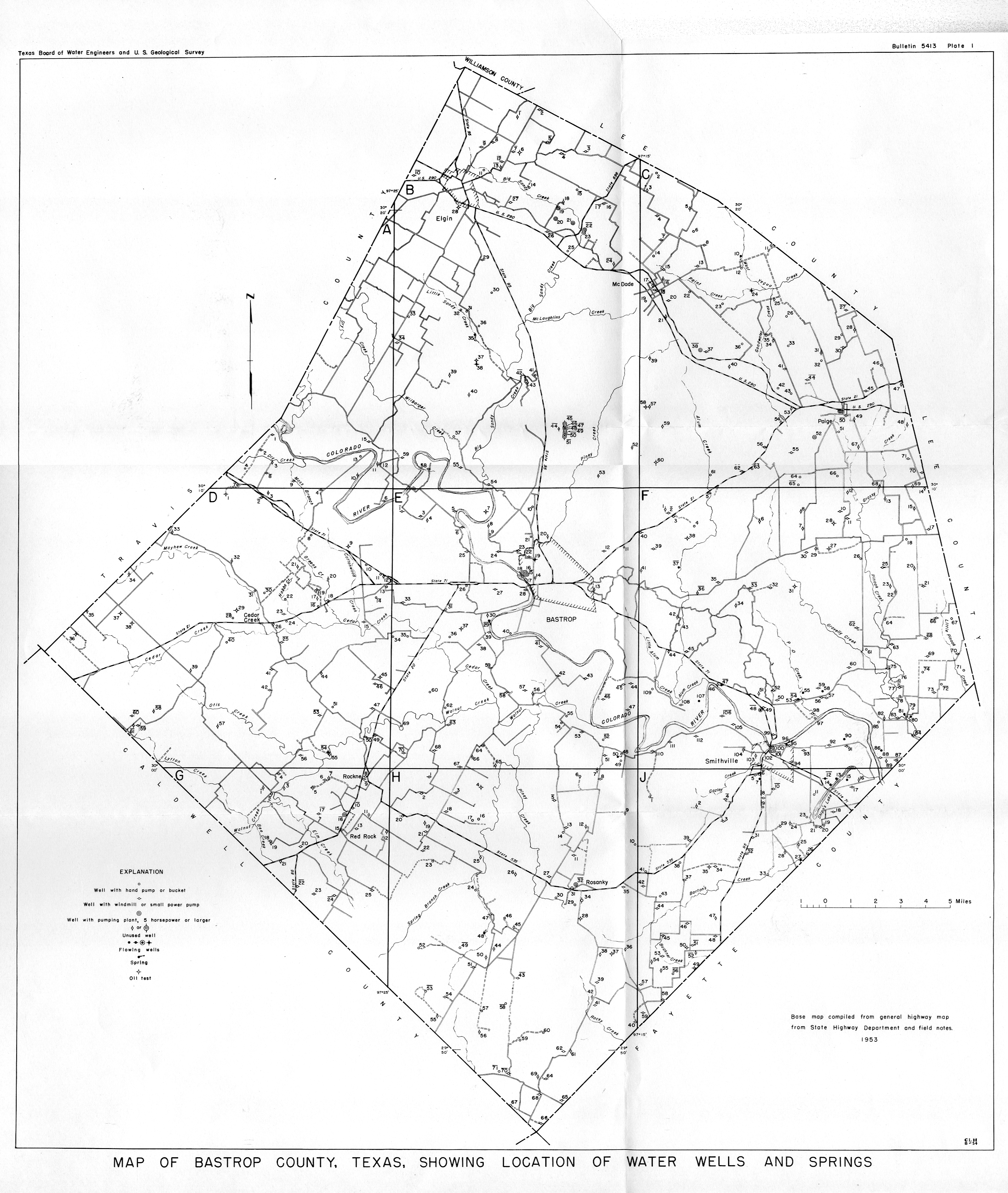
| 5413 | Records of Wells in Bastrop County, Texas Map of Bastrop County, Texas, Showing Location of Water Wells and Springs |
1954 |
| 5414 | Records of Water-Level Measurements in Reeves County, Texas | 1954 |
| 5415 | Records of Water-Level Measurements in Culberson, Hudspeth, and Jeff Davis Counties, Texas | 1954 |
| 5416 | Records of Water-Level Measurements in Atascosa and Frio Counties, Texas | 1954 |
| 5417 | Records of Water-Level Measurements in El Paso County, Texas | 1954 |
| 5418 | Ground Water Resources of Jones County, Texas | 1954 |
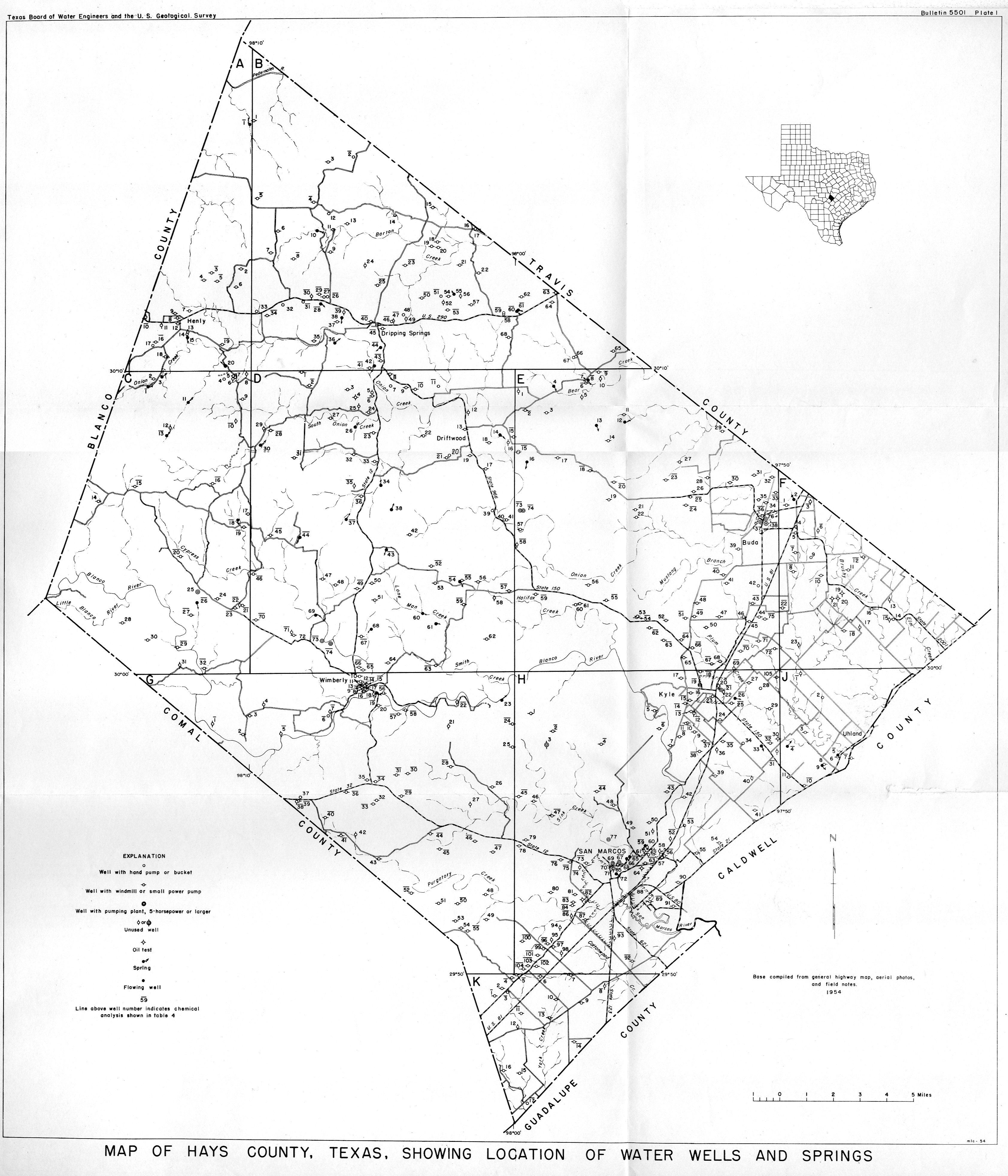
| 5501 | Records of Wells in Hays County, Texas Map of Hays County, Texas Showing Locations of Wells and Springs |
1955 |
| 5502 | Geology and Ground-Water Resources of Galveston County, Texas | 1955 |
| 5503 | Records of Water-Level Measurements in Haskell and Knox Counties, Texas | 1955 |
| 5601 | Geology and Ground-Water Resources of Medina County, Texas | 1956 |
| 5602 | Pumpage of Ground Water and Changes in Artesian Pressure in the Houston District and Baytown-La Porte Area, Texas, 1953-55 | 1956 |
| 5603 | Ground-Water Resources of the El Paso District, Texas | 1956 |
| 5604 | Ground-Water Resources of the Crane Sandhills, Crane County, Texas | 1956 |
| 5605 | Basic Data and Summary of Ground-Water Resources of Chambers County, Texas | 1956 |
| 5606 | Records of Water-Level Measurements in Bexar County, Texas | 1956 |
| 5607 | Water-Level Decline Maps of 17 Counties in the Southern High Plains, Texas | 1956 |
| 5608 Vol 1 | Ground-Water Resources of the San Antonio Area, a progress report on current studies | 1956 |
| 5608 Vol 2 Part 1 | Ground-Water Resources of the San Antonio Area, Records of Wells and Springs | 1956 |
| 5608 Vol 2 Part 2 | Ground-Water Resources of the San Antonio Area, Texas, Records of Drillers' Logs | 1956 |
| 5608 Vol 2 Part 3 | Ground-Water Resources of the San Antonio Area, Texas | 1956 |
| 5609 | Records of Water-Level Measurements in Medina County, Texas | 1956 |
| 5610 | Records of Water-Level Measurements in Comal and Guadalupe Counties, Texas | 1956 |
| 5611 | Records of Water-Level Measurements in Kinney, Uvalde and Val Verde Counties, Texas 1929 to March 1956 | 1956 |
| 5612 | Records of Water-Level Measurements in Hays, Travis, and Williamson Counties, Texas | 1956 |
| 5613 | Records of Water-Level Measurements in Childress, Cottle, Hardeman, and King Counties, Texas | 1956 |
| 5614 | Records of Water-Level Measurements in Foard and Wilbarger Counties, Texas | 1956 |
| 5615 | Ground-Water Resources of the Hueco Bolson, Northeast of El Paso, Texas | 1956 |
| 5617 | Records of Water-Level Measurements in Dimmit, Maverick, and Zavala Counties, Texas | 1956 |
| 5701 | Artificial-Recharge Experiments at McDonald Well Field, Amarillo, Texas | 1957 |
| 5702 | Records of Water Levels in Bastrop and Caldwell Counties, Texas 1937 through December 1956 | 1957 |
| 5703 | Records of Water Levels in Aransas and San Patricio Counties, Texas | 1957 |
| 5704 | Geology and Ground-Water Resources of Lamb County, Texas | 1957 |
| 5705 | Water Level Decline Maps, 1956 to 1957, and Water Levels in Observation Wells in 20 Counties in the Southern High Plains, Texas | 1957 |
| 5706 | The Use of Ground Water for Irrigation in Childress County, Texas | 1957 |
| 5707 | Water Level Maps and Water Levels in Observation Wells in the North High Plains, Texas | 1957 |
| 5708 | Records of Wells in Travis County, Texas | 1957 |
| 5709 | Geology and Ground-Water Resources of Tarrant County, Texas | 1957 |
| 5710 | Groundwater Geology of Wilson County, Texas (Second Printing 1975) | 1957 |
| 5711 | Ground-Water Resources of Goliad County, Texas | 1957 |
| 5712 | Ground-Water Geology of the Alpine Area, Brewster, Jeff Davis, and Presidio Counties, Texas | 1957 |
| 5801 | Ground-Water Geology in the Vicinity of Dove and Croton Creeks, Stonewall, Kent, Dickens, and King Counties, Texas | 1958 |
| 5802 | Ground-Water Conditions in Carson County, Texas | 1958 |
| 5803 | Groundwater Geology of Real County, Texas | 1958 |
| 5804 | Records of Water-Level Measurements in Jackson, Matagorda, and Wharton Counties, Texas, 1934 to April 1958 | 1958 |
| 5805 | Pumpage of Ground Water and Fluctuations of Water Levels in the Houston District and the Baytown-LaPorte Area, Texas, 1955-57 | 1958 |
| 5806 | Records of Water-Level Measurements in Collingsworth, Hemphill, and Wheeler Counties, Texas 1937 through July1958 | 1958 |
| 5807A | Part 1 | Part 2 Compilation of Surface Water Records in Texas through September 1957 | 1958 |
| 5807 B | Index of Surface Water Records 1882- 1957 | 1958 |
| 5807 C | Summary of Peak Flood Flow Measurements and Other Measurements of Stream Discharge in Texas at Points Other than Gaging Stations | 1959 |
| 5807 D | Channel Gain and Loss Investigations Texas Streams 1918-1958 | 1960 |
| 5807 E | Texas Stream-Gaging Program: Evaluation and Recommendations | 1960 |
| 5808 | Pumpage of Ground Water and Changes in Water Levels in Galveston County, Texas, 1952-57 | 1958 |
| 5901 | Records of Water-Level Measurements in Chambers, Liberty and Montgomery Counties, Texas, 1931 through April 1958 | 1959 |
| 5902 | Records of Water-Level Measurements in Bell, McLennan, and Somervell Counties, Texas 1930-1957 | 1959 |
| 5903 | Records of Water-Level Measurements in Crockett, Glasscock, Reagan, Upton, and Terrell Counties | 1959 |
| 5904 | Records of Water-Level Measurements in Brazoria, Fort Bend, and Waller Counties, Texas 1931 through June 1958 | 1959 |
| 5905 | Chemical Composition of Texas Surface Waters, 1956 | 1959 |
| 5906 | Records of Water-Level Measurements in Crane and Midland Counties, Texas 1937 through 1957 | 1959 |
| 5907 | Records of Water-Level Measurements in Mitchell, Nolan, Sterling, and Tom Green Counties, Texas 1938 through 1957 | 1959 |
| 5908 | Water-Level Measurements and Maps Southern High Plains, Texas 1958 through 1959 | 1959 |
| 5909 | Water-Level Measurements and Maps Northern High Plains, Texas 1958 and 1959 | 1959 |
| 5910 | Water Requirements Survey | 1959 |
| 5911 | Ground-water Geology for Bexar County, Texas | 1959 |
| 5912 | Inventory and Use of Sedimentation Data in Texas | 1959 |
| 5913 | Texas Index of Meteorological Data | 1959 |
| 5914 | A Study of Droughts in Texas | 1959 |
| 5915 | Chemical Composition of Texas Surface Waters, 1957 | 1959 |
| 5916 | Geology and Ground-Water Resources of Winkler County, Texas | 1959 |
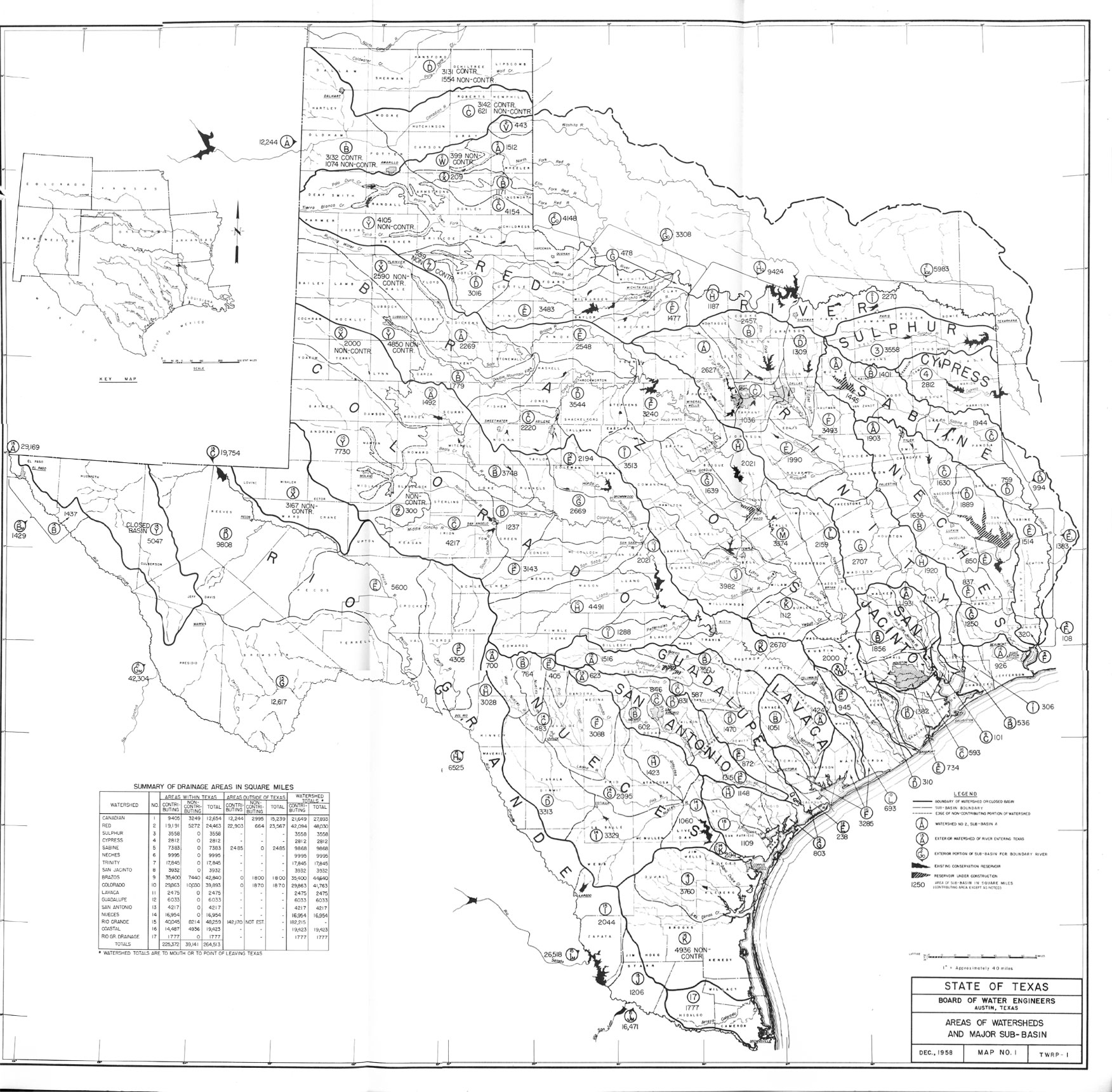
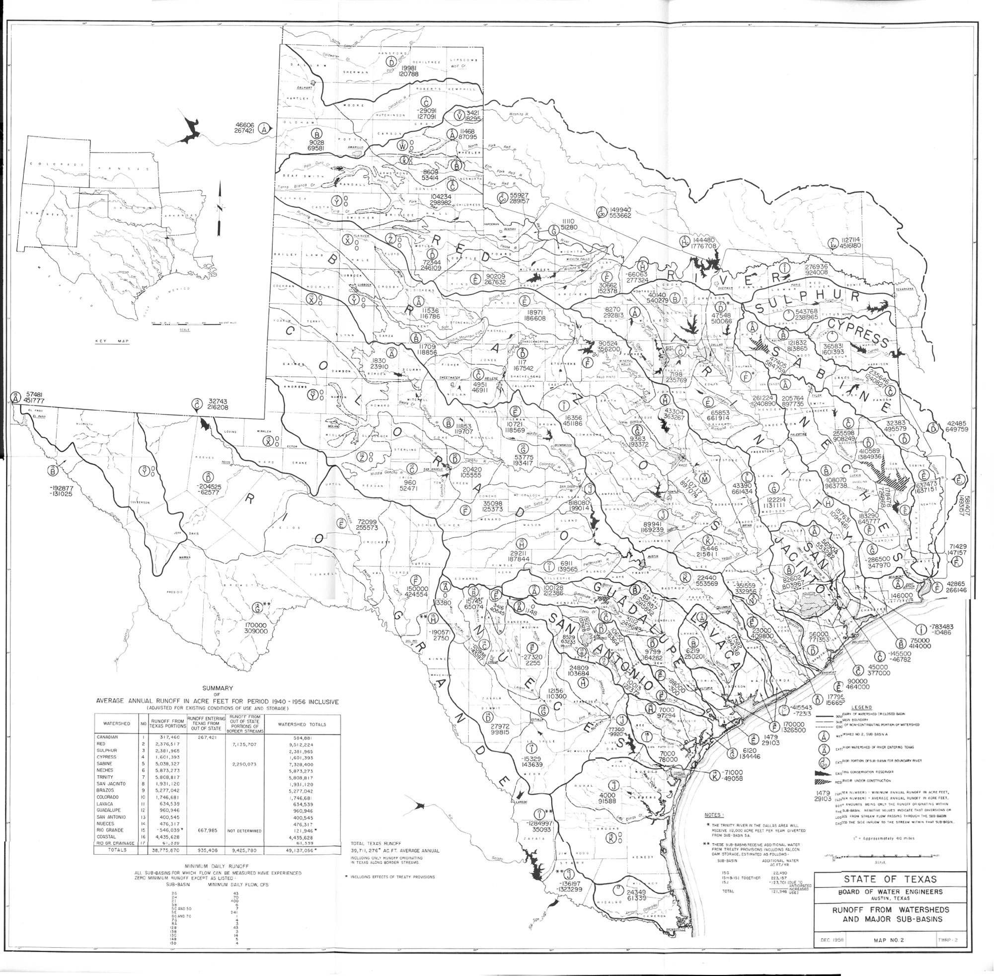
| 6001 | Surface Runoff from Texas Watersheds and Sub-basins map 1: Areas of watersheds & major sub-basins map 2: runoff from watersheds & major sub-basins |
1960 |
| 6002 | Brine Production and Disposal on the Lower Watershed of Chambers and Richland Creeks, Navarro County, Texas | 1960 |
| 6003 | Geology and Ground-Water Resources of Dimmit County, Texas (Second Printing 1975) | 1960 |
| 6004 | Geology and Ground-Water Resources of Hays County, Texas | 1960 |
| 6005 | Water-Level Measurements in Culberson, Hudspeth, and Jeff Davis Counties, Texas | 1960 |
| 6006 | Monthly Reservoir Evaporation Rates for Texas 1940-1957 | 1960 |
| 6007 | Ground-Water Geology of Karnes County, Texas | 1960 |
| 6008 | Water Levels in Observation Wells in Cameron, Hidalgo, and Starr Counties 1950-1959 | 1960 |
| 6009 | Water Levels in Observation Wells in Haskell and Knox Counties, Texas 1956-1960 | 1960 |
| 6010 | Ground-Water Resources of the Hale County, Texas | 1960 |
| 6011 | Water Levels in Observation Wells Southern High Plains, Texas 1959 and 1960 | 1960 |
| 6012 | Water Levels in Observation Wells Northern High Plains, Texas 1958-1960 | 1960 |
| 6013 | Geology and Ground-Water Resources of Grayson County, Texas | 1960 |
| 6014 Vol 1 | Ground-Water Resources of the Lower Rio Grande Valley Area, Texas | 1961 |
| 6014 Vol 2 | Ground-Water Resources of the Lower Rio Grande Valley Area, Texas | 1961 |
| 6015 | Water Levels in Observation Wells in Atascosa and Frio Counties, Texas 1955-1960 | 1960 |
| 6016 | Reconnaissance Investigation of the Ground Water Resources of the Canadian River Basin, Texas | 1960 |
| 6017 | Ground-Water Geology of the Hickory Sandstone Member of the Riley Formation, McCulloch County, Texas | 1961 |
| 6018 | Irrigation in Texas in 1958 | 1960 |
| 6019 | Consumptive Use of Water by Major Crops in Texas (Second Printing 1960) | 1960 |
| 6101 | Water Levels in Observation Wells Southern High Plains, Texas 1960 and 1961 | 1961 |
| 6102 | Geology and Ground-Water Resources of Carson County and Part of Gray County, Texas, Progress Report No.1 | 1961 |
| 6103 | Annual Water-Level Measurements in Observation Wells Northern High Plains, Texas 1960 and 1961 | 1961 |
| 6104 | Chemical Composition of Texas Surface Waters, 1958 | 1961 |
| 6105 | Groundwater Geology of Live Oak County, Texas | 1961 |
| 6106 | Geology and Ground-Water Resources of Pecos County, Texas | 1961 |
| 6107 | A Summary of the Occurrence and Development of Ground Water in the Southern High Plains of Texas | 1961 |
| 6108 | Silt Load of Texas Streams: a Compilation Report June 1889-September 1959 | 1961 |
| 6109 | Geology and Ground-Water Resources of the Northern High Plains of Texas | 1961 |
| 6110 | Ground-Water Reconnaissance of the Marfa Area, Presidio County, Texas | 1961 |
| 6111 | A Reconnaissance of the Ground-Water Resources of the Marathon Area, Brewster County, Texas | 1961 |
| 6201 | Recharge, Discharge, and Changes in Ground-Water Storage in the Edwards and Associated Limestones San Antonio Area, Texas. A Progress Report on Studies, 1955-59 | 1962 |
| 6202 | Ground-Water Resources of Victoria and Calhoun Counties, Texas | 1962 |
| 6203 | Ground-Water Resources of the Lower Mesilla Valley, Texas and New Mexico plates | 1962 |
| 6204 | Description of Ground Water in the El Paso District, Texas, 1955-60 | 1962 |
| 6205 | Chemical Composition of Texas Surface Waters, 1959 | 1962 |
| 6206 | Research in the Problem of Scaling of Electrodialysis Demineralizers | 1962 |
| 6207 | Water-Level Measurements through 1962 in Selected Observation Wells, Southern High Plains, Texas | 1962 |
| 6208 | Ground-Water Geology of Edwards County, Texas | 1962 |
| 6209 | Ground-Water Resources of Haskell and Knox Counties, Texas | 1962 |
| 6210 | Ground-Water Geology of Bandera County, Texas | 1962 |
| 6211 | Pumpage of Ground Water and Fluctuation of Water Levels in the Houston District and the Baytown-LaPorte Area, Texas, 1957-61 | 1962 |
| 6212 | Geology and Ground-Water Resources of Uvalde County, Texas | 1962 |
| 6213 | Annual Water-Level Measurements in Observation Wells Northern High Plains, Texas 1961 and 1962 | 1962 |
| 6214 Vol 1 | Geology and Ground-Water Resources of Reeves County, Texas (Second Printing 1972) 12 oversize Map Plates | 1962 |
| 6214 Vol 2 | Geology and Ground-Water Resources of Reeves County, Texas | 1962 |
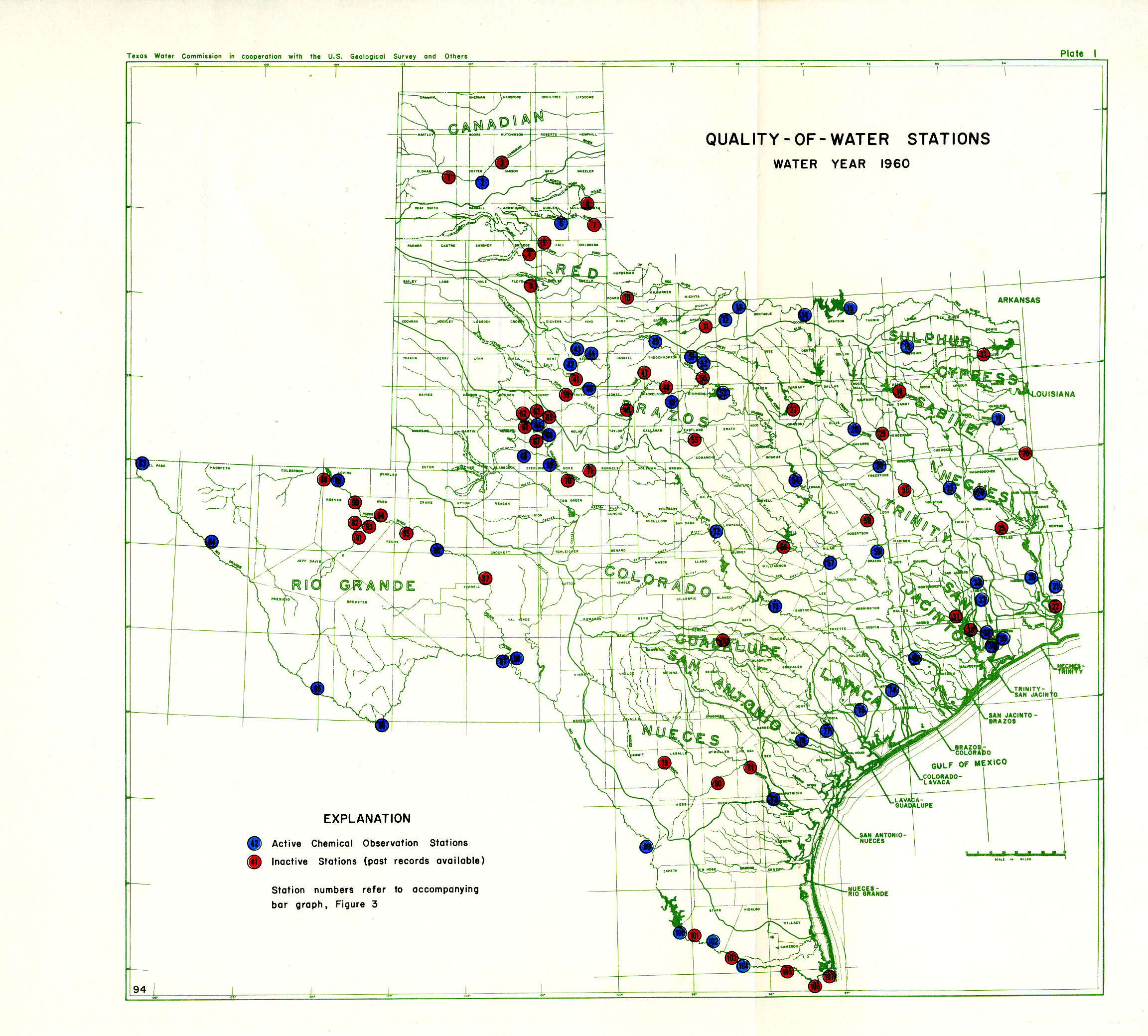
| 6215 | Chemical Composition of Texas Surface Waters, 1960 Map: Quality-of-Water stations 1960 |
1962 |
| 6216 | Geology and Ground-Water Resources of Kinney County, Texas | 1962 |
| 6301 | Availability of Ground Water from the Goliad Sand in the Alice Area, Texas | 1963 |
| 6302 | Availability and Quality of Ground Water in Smith County, Texas | 1963 |
| 6303 | Pumpage of Ground Water and Changes in Water Levels in Galveston County, Texas, 1958-62 | 1963 |
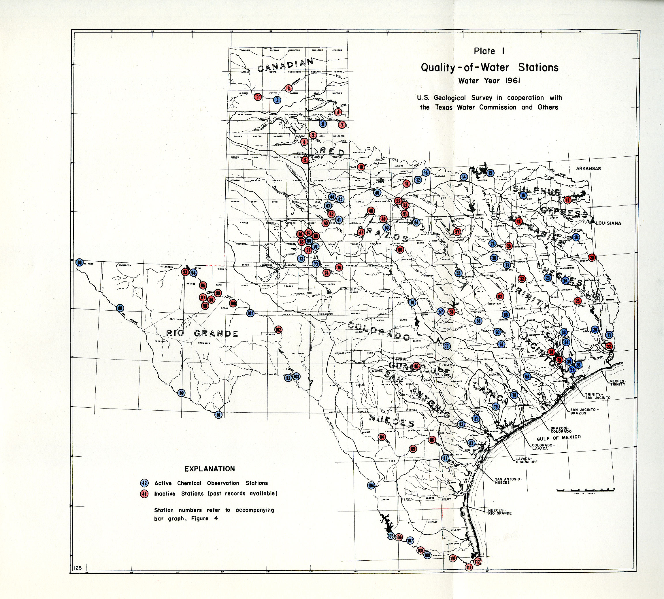
| 6304 | Chemical Composition of Texas Surface Waters, 1961 Plate 1 Quality- of- Water stations, 1961 |
1963 |
| 6305 | Reconnaissance Investigation of the Ground-Water Resources of the Gulf Coast Region, Texas | 1963 |
| 6306 | Reconnaissance Investigation of the Ground-Water Resources of the Red River, Sulphur River, and Cypress Creek Basins, Texas | 1963 |
| 6307 | Reconnaissance Investigation of the Ground-Water Resources of the Sabine River Basin, Texas | 1963 |
| 6308 | Reconnaissance Investigation of the Ground-Water Resources of the Neches River Basin, Texas | 1963 |
| 6309 | Reconnaissance Investigation of the Ground-Water Resources of the Trinity River Basin, Texas (Second printing 1973) Book of Oversize map plates is being scanned |
1963 |
| 6310 | Reconnaissance Investigation of the Ground-Water Resources of the Brazos River Basin, Texas | 1973 |
| 6311 | Floods in Texas, Magnitude and Frequency of Peak Flows plate 1: Map showing gaging stations and floor-frequency regions Plate 2: Map showing gaging stations and hydrologic areas |
1963 |
| 6312 | Ground-Water Resources for Refugio County, Texas | 1963 |
| 6401 | Research on Evaporation Retardation in Small Reservoirs 1958-63 | 1964 |
| 6402 | Geology and Ground-Water Resources of Carson County and Part of Gray County, Texas | 1964 |
| 6403 | Fifty Years of Water Development in Texas | 1964 |
| 6404 | Conservation Storage Reservoirs in Texas Some Aspects and Chronology of Surface-Water Resources Development | 1964 |
| 6405 | Reconnaissance of the Chemical Quality of Surface waters of the Sabine River Basin Texas and Louisiana | 1964 |
| 6406 | Geology and Ground-Water Resources of Hardin County, Texas | 1964 |
| 6407 | Base-Flow Studies Pedernales River, Texas | 1964 |
| 6408 | Dams and Reservoirs in Texas Historical & Descriptive Info | 1964 |
| 6409 | Reconnaissance Investigation of the Ground-Water Resources of the Guadalupe, San Antonio, and Nueces River Basins, Texas | 1964 |
| 6410 | Suspended-Sediment Load of Texas Streams Compilation Report, October 1959-September 1961 | 1964 |
| 6411 | Chemical Quality of Surface Waters in the Hubbard Creek Watershed, Texas, Progress Report, September 1963 | 1964 |
| 6412 | Occurrence and Quality of Ground Water in Stephens County, Texas | 1964 |
| 6413 | Water-Supply Limitations on Irrigation from the Rio Grande in Starr, Hidalgo, Cameron, and Willacy Counties, Texas | 1964 |
| 6413A | Appendices to Bulletin 6413 (Water-Supply Limitations on Irrigation from the Rio Grande in Starr, Hidalgo, Cameron, and Willacy Counties, Texas) | 1965 |
| 6414 | Analysis of Unit Hydrographs for Small Watersheds in Texas | 1964 |
| 6415 | Occurrence and Quality of Ground Water in Young County, Texas | 1964 |
| 6501 | Chemical Composition of Texas Surface Waters, 1962 | 1965 |
| 6502 | Reconnaissance Investigations of the Ground-Water Resources of the Rio Grande Basin, Texas | 1965 |
| 6503 | Base-Flow Studies, Guadalupe River Comal County, Texas | 1965 |
| 6504 | The Current Status of Weather Modification A Summary - 1964 | 1965 |
| 6505 | Base-Flow Studies Llano River, Texas | 1965 |
| 6506 | Base-Flow Studies Lampasas River, Texas | 1965 |
| 6507 | Water-Level Data From Observation Wells in Pecos and Reeves Counties, Texas | 1965 |
| 6508 | Analog Model Study of Ground Water in the Houston District, Texas | 1965 |
| 6509 | Water-Delivery Study Nueces River, Texas, Quantity and Quality, August 1963 | 1965 |
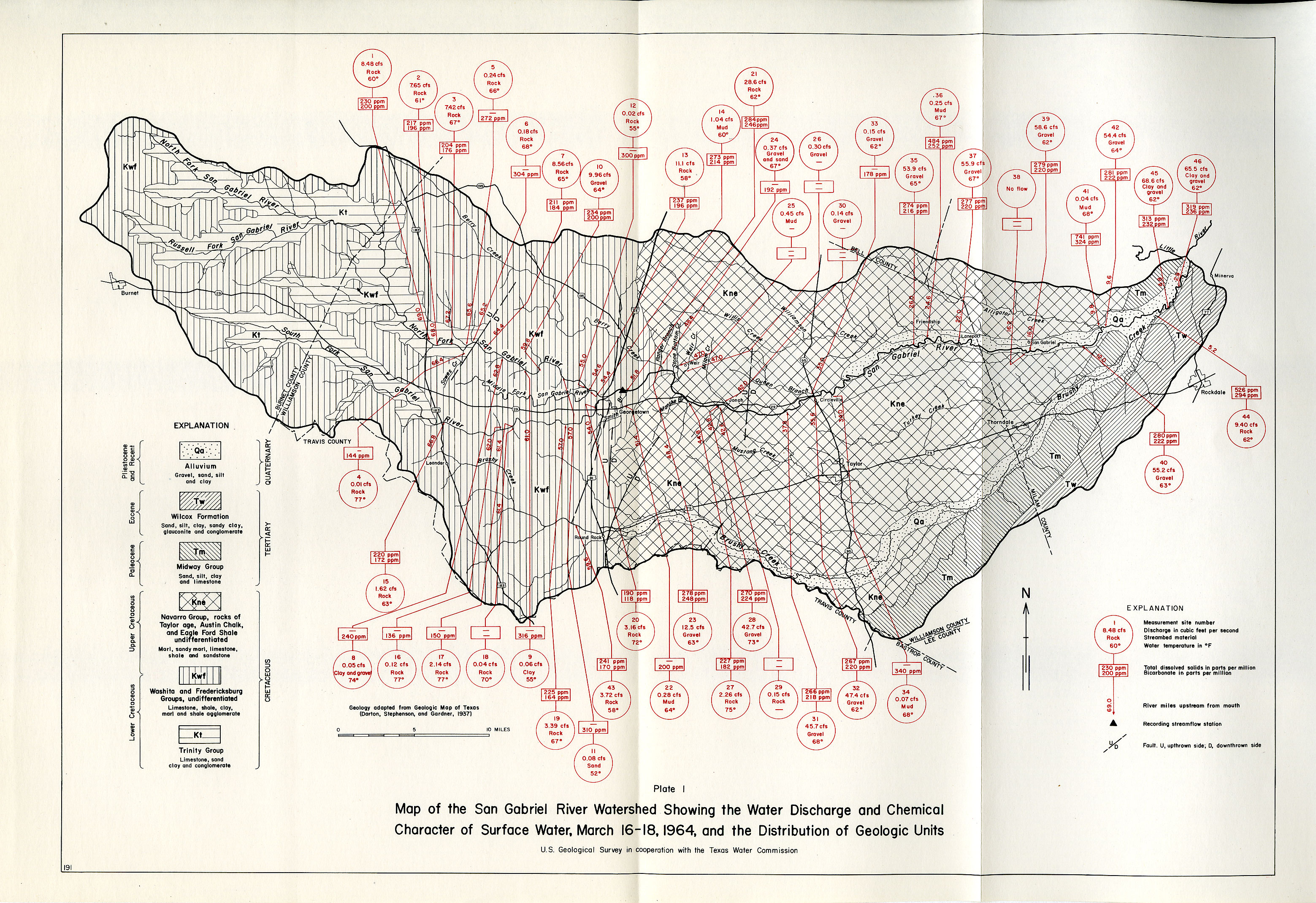
| 6510 | Base-flow Studies San Gabriel River, Texas, Quantity and Quality, March 16-18, 1964 Plate 1 Map of the San Gabriel River watershed |
1965 |
| 6511 | Base-flow Studies Cibolo Creek, Texas, Quantity and Quality, March 5-7, 1963 plate 1 Map of discharge measurements & river channel geology, Cibolo creek 1963 |
1965 |
| 6512 | Symposium on Consideration of Droughts in Water Planning | 1965 |
| 6513 | Availability and Quality of Ground Water in Leon County, Texas | 1965 |
| 6514 | Development of Ground Water in the El Paso District, Texas, 1960-63 | 1965 |
| 6515 | Inventory of Texas Irrigation | 1965 |
| 6516 | Geology and Ground-Water Resources of Orange County, Texas (Second Printing 1970) | 1965 |
| 6517 | Ground-Water Resources of Camp, Franklin, Morris and Titus Counties, Texas (Second Printing 1975) | 1965 |
| 6518 | Ground-Water Resources of DeWitt County, Texas | 1965 |
| 6519 | Ground-Water Resources of Menard County, Texas (Second Printing 1970) | 1965 |
| 6520 | Ground-Water Resources of La Salle and McMullen Counties, Texas plates | 1965 |
| 6521 | Investigation of Ground-Water Contamination, Rhineland Area Knox County, Texas | 1965 |