Texas Water Service Boundary Viewer (TWSBV) Editor
The water service boundaries will not be available for editing in 2026.
The TWSBV application is still available for the public to view water system boundaries.
If you would like to update the boundaries for your system while the application is closed for editing, please contact WSBViewer@twdb.texas.gov. You are not required to update your service boundary for the current reporting year.
Overview
The Texas Water Development Board (TWDB) has developed a statewide public water system service area mapping application called the Texas Water Service Boundary Viewer (TWSBV) through a grant from the U.S. Geological Survey (USGS) Water Availability and Use Science Program. While several water system mapping applications exist in the state, they do not necessarily represent the actual retail water service areas or include all the public water systems (PWS) within the state. This mapping application strives to collect and provide the most up-to-date and best data available on the water service areas for all community PWS within Texas.
Go to Texas Water Service Boundary Viewer (for the public)
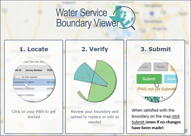
For more information on the TWSBV application, please visit the FAQ and Guidance Video Page
The application is available to the public to view the water service boundaries and related reports including historical water use and Texas Commission on Environmental Quality public water system information. No sign in is needed.
User Guide for Public
The water service boundaries will not be available for editing in 2026. You are not required to update your service boundary for the current reporting year. If you would like to update the boundaries for your system while the application is closed for editing, please contact WSBViewer@twdb.texas.gov.
If you need any assistance, please contact the administrator at WSBviewer@twdb.texas.gov .
This material is based upon work supported by the U.S. Geological Survey under Cooperative Agreement No. G17AC00016. The views and conclusions contained in this document are those of the authors and should not be interpreted as representing the opinions or policies of the U.S. Geological Survey. Mention of trade names or commercial products does not constitute their endorsement by the U.S. Geological Survey.