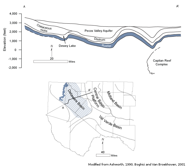
Rustler Aquifercross-section
Aquifer Facts
- Aquifer type: confined and unconfined
- Area of outcrop: 311 square miles
- Area of subsurface: 4,881 square miles
- Proportion of aquifer with groundwater conservation districts: 76 percent
- Number of counties containing the aquifer: 7
Summary
The Rustler Aquifer is a minor aquifer located in Brewster, Culberson, Jeff Davis, Loving, Pecos, Reeves, and Ward counties. The aquifer consists of the carbonates and evaporites of the Rustler Formation, which is the youngest unit of the Late Permian Ochoa Series. The Rustler Formation is 250 to 670 feet thick and extends downdip into the subsurface toward the center of the Delaware Basin to the east. It becomes thinner along the eastern margin of the Delaware Basin and across the Central Basin Platform and Val Verde Basin. There it conformably overlies the Salado Formation. Groundwater occurs in partly dissolved dolomite, limestone, and gypsum. Most of the water production comes from fractures and solution openings in the upper part of the formation.
Although some parts of the aquifer produce freshwater containing less than 1,000 milligrams per liter of total dissolved solids, the water is generally slightly to moderately saline and contains total dissolved solids ranging between 1,000 and 4,600 milligrams per liter.
The water is used primarily for irrigation, livestock, and waterflooding operations in oil-producing areas.
Reports
| ID | Date | Type | Description |
|---|---|---|---|
| Texas Aquifers Study | 12/31/2016 | Legislative Report | Texas Aquifers Study: Groundwater Quantity, Quality, Flow, and Contributions to Surface Water |
| R-317 | 1/1/1990 | TWDB numbered report | Evaluation of Ground-Water Resources in Parts of Loving, Pecos, Reeves, Ward and Winkler Counties, Texas |
| HA-09 | 1/1/1998 | Hydrologic atlas | Water Quality in the Rustler Aquifer |
| R-356 | 12/1/2001 | TWDB numbered report | Aquifers of West Texas |
| AA06-01 | 6/10/2008 | Aquifer assessment | Water-level decline scenarios for the Capitan Reef Complex, Marathon, Rustler, Presidio-Redford Bolson, Edwards-Trinity (Plateau), and Diablo Plateau aquifers in Groundwater Management Area 4 |
| AA09-11 | 9/21/2010 | Aquifer assessment | Desired future condition scenarios for the Rustler Aquifer in Groundwater Management Area 4 |
| AA10-25_MAG | 8/23/2011 | Aquifer assessment MAG | Managed available groundwater estimates for the Rustler Aquifer in Groundwater Management Area 4 |
| AA10-37_MAG | 11/3/2011 | Aquifer assessment MAG | Modeled available groundwater for the Rustler Aquifer in Groundwater Management Area 3 |
| AA10-13_MAG | 11/18/2011 | Aquifer assessment MAG | Modeled available groundwater for the Rustler Aquifer in Groundwater Management Area 7 |
| AA10-13_MAG | 11/18/2011 | Aquifer assessment MAG | Modeled available groundwater for the Rustler Aquifer in Groundwater Management Area 7 |
| R-380 | 7/1/2011 | TWDB numbered report | Aquifers of Texas |
| GR12-023_MP_Add | 2/11/2013 | GAM run - Management Plan | Addendum to GAM Run 12-023 to include Ruster Aquifer information |
| GT13-027_TERS | 9/19/2013 | GAM task - Total Estimated Recoverable Storage | Total Estimated Recoverable Storage for aquifers in Groundwater Management Area 3 |
| GT13-030_TERS | 10/2/2013 | GAM task - Total Estimated Recoverable Storage | Total Estimated Recoverable Storage for aquifers in Groundwater Management Area 7 |
| GR13-020_MP | 10/7/2013 | GAM run - Management Plan | Management Plan data for Brewster County GCD |
| GT13-028_TERS | 1/15/2014 | GAM task - Total Estimated Recoverable Storage | Total Estimated Recoverable Storage for aquifers in Groundwater Management Area 4 |
| GR14-010_MP | 3/26/2014 | GAM run - Management Plan | Management Plan data for Middle Pecos GCD |
| GR18-001_MP | 5/10/2018 | GAM run - Management Plan | Management plan information for Reeves County GCD |
| GR19-008_MP | 2/27/2019 | GAM run - Management Plan | Management plan information for Brewster County GCD |
| GR19-021_MP | 2/20/2020 | GAM run - Management Plan | Management plan information for Middle Pecos GCD |
| GR23-001_MP | 5/10/2023 | GAM run - Management Plan | Management plan information for Reeves County GCD |
| GR23-010_MP | 06/07/2023 | GAM run - Management Plan | Management plan information for Jeff Davis County UWCD |