Lake Houston (San Jacinto River Basin)
 Lake Houston is located four miles north of Sheldon and eighteen miles northeast of Houston in Harris County, on the San Jacinto River. The lake is owned by the City of Houston and operated and maintained by the Coastal Water Authority, for municipal, industrial, recreational, mining, and irrigation purposes. Dam construction commenced in November, 1951 and was completed in December, 1953. Deliberate impoundment of water began April 9, 1954. Ambursen Engineering Company designed the original structure. The general contractors were Elmer Gardner Construction Company and Swope Brothers. In 1970, Brown and Root engineered modifications for erosion control work immediately downstream of the dam.
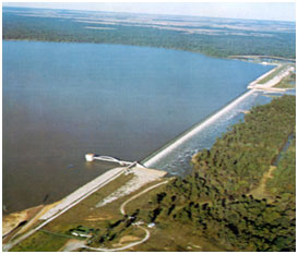
In the following years, Ebasco Engineering and Construction Company designed the plans for dam reparations and LEM Construction was the contractor for the work performed in 1986 and 1987. Lake Houston's dam consists of a conventional Ambursen reinforced concrete slab and buttress spillway section that is 3,160 feet in length. The spillway has a crest elevation of 41.73 feet above mean sea level (NAVD88). It has an overflow diffusion grill that discharges water into a stilling pool. The spillway is flanked by two compacted earth-fill embankments. The left embankment section is 4,000 feet long while the right embankment is 4,600 feet in length with a maximum height of 48 feet. The top of the dam is at elevation of 60.23 feet above mean sea level. Maximum design water surface is 54.23 feet above mean sea level. Water release is controlled by 2 tainter gates (each 18 by 20.5 feet) located between the earthfill section and the spillway section. Elevation of tainter gate sill 25.23 feet above mean sea level, while the top of the gate is at elevation of 45.73 feet above mean sea level. The reservoir's main body of water is located between the dam and confluence of the West and East Forks of the San Jacinto River. According to TWDB 2011 volumetric survey, the lake has a storage capacity of 134,122 acre-feet encompassing a surface area of 11,282 acres at its normal operating elevation 42.4 feet above mean sea level (NAVD88). Records indicate the drainage basin is approximately 2,828 square miles, of which 445 square miles are controlled by Conroe Dam.