River Basins & Reservoirs
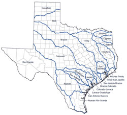
 Texas has approximately 191,000 miles of streams, 15 major river basins, eight coastal basins, and 196 major reservoirs.
Texas River Basins
The unique features of each of these basins are a function of many factors, but one of the most critical is precipitation, which varies from less than 10 inches per year in the western part of the state to more than 55 inches per year in the east. Other factors include evaporation, vegetation, soil type, surface slope, geology, land use practices, and runoff.
Texas Lakes & Reservoirs
Major reservoir being defined as an impoundment that currently has at least 5,000 acre-feet of storage capacity at its normal operating level. Texas has 188 major water-supply reservoirs, and over 20 additional major reservoirs that serve no water-supply function. The major reservoirs of the state vary in size from 5,200 acre-feet conservation storage capacity for the Upper Nueces Lake to 4,472,900 acre-feet for the Toledo Bend Reservoir, which includes both the Louisiana and Texas portions of the reservoir (Appendix 6.1). Making the best use of existing reservoirs, controlling watershed erosion to maintain their holding capacity, and identifying viable sites for new reservoirs are key to effective long-term water supply management and planning in Texas.