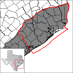
Northern portion of the Gulf Coast Aquifer System Groundwater Availability Model (GAM)
 In October 2019, the US Geological Survey in cooperation with the Harris-Galveston Subsidence District and the Fort Bend Subsidence District began updating the groundwater flow model for the northern portion of the Gulf Coast Aquifer System. The TWDB and the Harris-Galveston Subsidence District signed a letter of agreement that once the model and other deliverables satisfy the technical standards and procedural requirements of the TWDB GAM Program, the model, report, and source data will replace the Houston Area Groundwater Model (HAGM) as the GAM for the area. The model, known as the GULF-2023 model, was completed and released in February 2024.
Groundwater Management Area 14 adopted an update to v4.01 of the northern portion of the Gulf Coast Aquifer System groundwater availability model developed by the Lone Star Groundwater Conservation District. This updated model (v4.1) was released in January 2026.
Model Files and Associated Data
Please see the GAM files download page for the current model files and associated data.
Aquifer data is only available as a package for the entire model area and requires GIS software for processing. Please see the GAM files download page for aquifer data.
Joint Regulatory Plan Review Meetings (JRPR)
| ID | Date | Location |
|---|---|---|
| JRPR-1 | 05/20/2020 | Online meeting; click at left for meeting video and other materials. You will be leaving the TWDB website. |
| JRPR-2 | 09/30/2020 | Online meeting; click at left for meeting video and other materials. You will be leaving the TWDB website. |
| JRPR-3 | 12/10/2021 | Online meeting; click at left for meeting video and other materials. You will be leaving the TWDB website. |
| JRPR-4 | 06/08/2021 | Online meeting; click at left for meeting video and other materials. You will be leaving the TWDB website. |
| JRPR-5 | 12/14/2021 | Online meeting; click at left for meeting video and other materials. You will be leaving the TWDB website. |