Edwards-Trinity (High Plains) Aquifercross-section
Aquifer Facts
- Aquifer type: mostly confined
- Area of aquifer: 7,912 square miles
- Proportion of aquifer with groundwater conservation districts: 98 percent
- Number of counties containing the aquifer: 15
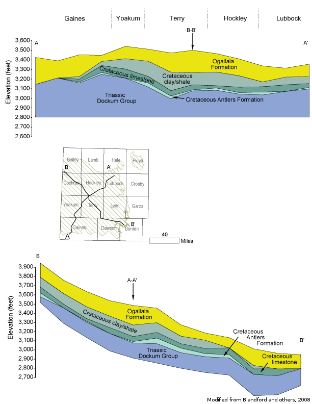
Summary
The Edwards-Trinity (High Plains) Aquifer is a minor aquifer that underlies about 9,000 square miles of the Ogallala Aquifer in western Texas and eastern New Mexico. Its water-producing units include sandstone of the Antlers Formation (Trinity Group) and limestone of the overlying Comanche Peak and Edwards formations. Regional groundwater flow in the aquifer is to the southeast, but locally flow is determined by the presence of Ogallala-filled paleochannels incised into the Cretaceous limestone. Recharge to the aquifer is primarily due to downward leakage from the younger Ogallala Aquifer. The greatest amount of recharge most likely occurs where low-permeability clay layers of the Duke Creek and Kiamichi formations, which lie between the Edwards-Trinity (High Plains) and Ogallala aquifers, are missing or thin or relatively permeable.
Groundwater typically contains more total dissolved solids than does the overlying Ogallala Aquifer. It generally is slightly saline, with total dissolved solids ranging from 1,000 to 2,000 milligrams per liter, but can range from 400 to more than 3,000 milligrams per liter. Groundwater is poorest in quality, with total dissolved solids in excess of 20,000 milligrams per liter, where the aquifer is overlain by saline lakes or the gypsum-rich Tahoka and Double Lakes formations. Freshwater saturated thickness in the aquifer averages 126 feet.
The aquifer provides water for irrigation, which uses approximately 95 percent of all groundwater that is pumped.
Reports
| ID | Date | Type | Description |
|---|---|---|---|
| Texas Aquifers Study | 12/31/2016 | Legislative Report | Texas Aquifers Study: Groundwater Quantity, Quality, Flow, and Contributions to Surface Water |
| B-6010 | 11/1/1960 | Groundwater bulletin | Geology and Ground-Water Resources of Hale County, Texas |
| R-015 | 2/1/1966 | TWDB numbered report | Ground-Water Resources of Gaines County, Texas |
| R-314 | 3/1/1989 | TWDB numbered report | Hydrogeology of Lower Cretaceous Strata Under the Southern High Plains of Texas and New Mexico |
| B-6310 | 12/1/1973 | Groundwater bulletin | Reconnaissance Investigation of the Ground-Water Resources of the Brazos River Basin, Texas |
| R-313 | 2/1/1989 | TWDB numbered report | Evaluation of Ground-Water Resources in Briscoe, Hale, and Swisher Counties, Texas |
| GR11-009_MP | 6/24/2011 | GAM run - Management Plan | Management plan information for High Plains UWCD No. 1 |
| GT11-010 | 6/14/2011 | GAM task | Total pumping estimates for the Ogallala, Edwards-Trinity (High Plains), and Dockum aquifers in High Plains UWCD No. 1 |
| GR09-027 | 6/21/2010 | GAM run | Predictive simulations for the Ogallala and Edwards-Trinity (High Plains) aquifers in Groundwater Management Area 7 |
| GR09-023 | 5/21/2010 | GAM run | Predictive simulation for the Ogallala and Edwards-Trinity (High Plains) aquifers in Groundwater Management Area 2 |
| GR09-018_MP | 7/24/2009 | GAM run - Management Plan | Management plan information for Llano Estacado UWCD |
| GR09-007_MP | 3/17/2009 | GAM run - Management Plan | Management plan information for Garza County UWCD |
| GR09-006_MP | 3/17/2009 | GAM run - Management Plan | Management plan information for High Plains UWCD No. 1 |
| GR09-005_MP | 3/17/2009 | GAM run - Management Plan | Management plan information for Sandy Land UWCD |
| GT10-023 | 6/8/2010 | GAM task | Predictive simulations for the Ogallala and Edwards-Trinity (High Plains) aquifers in Groundwater Management Area 2 |
| GR12-008_MP | 6/20/2012 | GAM run - Management Plan | Management plan data for Mesa UWCD |
| R-380 | 7/1/2011 | TWDB numbered report | Aquifers of Texas |
| GR13-022_MP | 8/28/2013 | GAM run - Management Plan | Management plan data for Sandy Land UWCD |
| GR13-021_MP | 8/28/2013 | GAM run - Management Plan | Management plan data for Garza County UWCD |
| GT13-026_TERS | 9/19/2013 | GAM task - Total Estimated Recoverable Storage | Total Estimated Recoverable Storage for aquifers in Groundwater Management Area 2 |
| GT13-042_TERS | 11/1/2013 | GAM task - Total Estimated Recoverable Storage | Total Estimated Recoverable Storage by county for aquifers in High Plains UWCD No. 1 |
| GR14-002_MP | 6/30/2014 | GAM run - Management Plan | Management plan data for Llano Estacado UWCD |
| GT15-006_TERS | 12/17/2015 | GAM task - Total Estimated Recoverable Storage | Total Estimated Recoverable Storage for aquifers in Groundwater Management Area 1 |
| GR18-004_MP | 3/29/2018 | GAM run - Management Plan | Management plan information for South Plains UWCD |
| GR18-009_MP | 5/25/2018 | GAM run - Management Plan | Management plan information for Mesa UWCD |
| GR18-014_MP | 1/15/2019 | GAM run - Management Plan | Management plan information for Sandy Land UWCD |
| GR19-011_MP | 2/27/2019 | GAM run - Management Plan | Management plan information for Cow Creek GCD |
| GR19-002_MP | 3/1/2019 | GAM run - Management Plan | Management plan information for High Plains UWCD #1 |
| GR19-001_MP | 5/3/2019 | GAM run - Management Plan | Management plan information for Garza County UWCD |
| GR19-017_MP | 7/22/2019 | GAM run - Management Plan | Management plan information for Llano Estacado UWCD |
| GR23-007_MP | 5/1/2023 | GAM run - Management Plan | Management plan information for South Plains UWCD |
| GR23-022_MP | 09/19/2023 | GAM run - Management Plan | Management plan information for Mesa UWCD |
| GR23-024_MP | 12/14/2023 | GAM run - Management Plan | Management plan information for Sandy Land Underground Water Conservation District |
| GR24-004_MP | 03/14/2024 | GAM run - Management Plan | Management plan information for Garza County UWCD |
| GR24-006_MP | 05/20/2024 | GAM run - Management Plan | Management plan information for High Plains UWCD #1 |