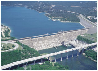
Lake Travis (Colorado River Basin)
 Lake Travis and Mansfield Dam are located approximately thirteen miles northwest of Austin in Travis County (extending into Burnet County), on the Colorado River. The project is owned and operated by the Lower Colorado River Authority for flood control, water supply, electrical power generation and recreational purposes. In December 1936 the United States Department of the Interior authorized the Lower Colorado River Authority to construct a low dam at the site of an old crossing on the river known as Marshall Ford. Construction of the Marshall Ford Dam started in March 1937 and was completed in July 1939. Additional construction with concrete, earth, and rockfill structure that replaced the original dam was completed in May 1942. Deliberate impoundment of water began in September 1940. The first power production unit began operation on January 27, 1941. The dam was renamed for U.S. Rep. J.J. Mansfield, who assisted in the project's development. The present dam has a total length of 7,098 feet with a maximum height of 266 feet and the top of dam is at the elevation of 750 feet above mean sea level. The maximum design water surface may reach to 748.9 feet above mean sea level. According to the TWDB 2008 volumetric survey (LiDAR dataset), Lake Travis has a storage capacity of 1,134,956 acre-feet encompassing a surface area of 19,297 acres at conservation pool elevation (681.6 feet NAVD88). At the flood pool elevation 714.6 feet above mean sea level (NAVD88), the total storage capacity of Lake Travis is 1,921,731 acre-feet, encompassing a surface area of 29,160 acres. The drainage area above the dam is 38,130 square miles, of which 11,900 is probably noncontributing. Runoff is partly regulated by Lake Buchanan and other reservoirs upstream.