Water Level Program
The TWDB measures groundwater levels annually in nearly 2,000 wells completed in the 30 major and minor aquifers and located throughout the state. The majority of these wells are used for irrigation, household needs, and stock watering, although some are owned by small commercial water suppliers or used for industrial purposes. TWDB personnel measure depths to water in accordance with procedures outlined in the TWDB Water-Level Measuring Manual (updated September 2016). Typically they use steel tapes, sometimes electric lines and sonic detectors, or even pressure gauges if the water is under artesian pressure and rises above land surface. Annual water levels are measured during cooler months when groundwater pumping is minimal and the water levels are most indicative of static or ambient conditions.
We cooperate with nearly 50 groundwater conservation districts, federal entities such as the US Geological Survey, and numerous additional municipalities to collect water-level measurements. Currently cooperators provide at least an additional 8,000 measurements annually that are entered in the TWDB groundwater database. They measure some wells more than once a year, depending on the needs of their specific programs, and provide water-level data to the TWDB. Of all wells measured, approximately 4,000 are considered part of an "ideal" water-level monitoring network by the TWDB, based on monitoring targets of one well per 25 to one well per 125 square miles per major and minor aquifer, and depending on amount of groundwater pumpage.
Online Recorder Program
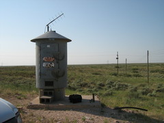
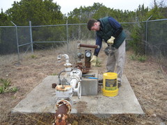
As of January 1, 2023, the TWDB maintained 256 water-level recorders, solely or in cooperation with groundwater districts, in 103 counties at wells also equipped with satellite telemetry. These automatic recorders transmit near-real-time water level data via the Geostationary Operational Environmental Satellite or GOES system. TWDB receives this information and publishes daily water level data. The equipment at each site typically consists of dataloggers attached to water level recording devices, such as transducers or floats and pulleys; satellite transmitters; power sources, including solar panels; antennae; and equipment shelters.
Procedures for maintenance and troubleshooting are found in the TWDB's Field Manual for Automated Water Level Recorders. An ever increasing number of groundwater conservation districts have been able to purchase recorders and transmitters, install equipment with the help of TWDB staff, and publish data from their wells on the TWDB web site. The TWDB is currently actively seeking funding for installation of more recorders in the remaining counties in the state.