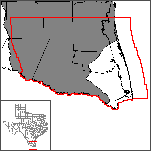
Southern portion of the Gulf Coast Aquifer SystemGroundwater Availability Model (GAM)
Work is underway to update the groundwater availability models for both the Central and Southern sections of the Gulf Coast Aquifer. Please see the page for the Gulf Coast Aquifer System Groundwater Availability Model, which will include both GMAs 15 and 16.
 The Texas Water Development Board (TWDB) has developed a model of the Gulf Coast Aquifer System in the Lower Rio Grande Valley of Texas. The model was completed in 2003.
In 2007, TWDB completed an update to the original model for the southern portion of the Gulf Coast Aquifer System. The report for the updated model has been released as TWDB Report 368.
Current GAM
Model Report
"Groundwater Resource Evaluation and Availability of the Gulf Coast Aquifer in the Lower Rio Grande Valley of Texas." (2007) | erratum
Other Reports
"Estimation of Groundwater Recharge to the Gulf Coast Aquifer in Texas, USA."
Model Files and Associated Data
Please see the GAM files download page for the current model files and associated data.
Aquifer data is only available as a package for the entire model area and requires GIS software for processing. Please see the GAM files download page for aquifer data.
Stakeholder Advisory Forums (SAF)
Send us an email if you would like to receive SAF notifications.
| ID | Date | Location |
|---|---|---|
| SAF 4 | 1/15/2003 | McAllen, Texas |
| SAF 3 | 4/26/2002 | McAllen, Texas |
| SAF 2 | 8/30/2001 | Laredo, Texas |
| SAF 1 | 1/17/2001 | McAllen, Texas |
Other Resources
Please see the Gulf Coast Aquifer System, the GMA 16 Groundwater Flow Model, and the Research Projects in Support of Groundwater Models pages for other reports and publications.
For model runs see the GMA 16 page.