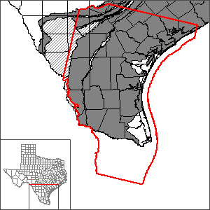
Groundwater Management Area 16 Groundwater Flow Model
The Groundwater Management Area 16 model includes portions of the underlying Gulf Coast, Yegua-Jackson, Queen City, Sparta, and Carrizo-Wilcox aquifer systems. The model was developed in an effort to provide results useful to Groundwater Management Area 16, because the existing groundwater availability models for the central portion of the Gulf Coast Aquifer and the southern portion of the Gulf Coast Aquifer do not individually encompass the footprint for Groundwater Management Area 16, nor do they include the Yegua-Jackson, Queen City, Sparta, or Carrizo-Wilcox aquifer systems. The purpose of this model, therefore, was focused on use as a tool in developing desired future conditions.
Work is underway to update the groundwater availability models for the Central and Southern sections of the Gulf Coast Aquifer. Please see the page for the Gulf Coast Aquifer System Groundwater Availability Model, which will include both GMAs 15 and 16.
Model Report
"Groundwater Management Area 16 Groundwater Flow Model." | DRAFT
Model Files
Please see the GAM files download page for model files.
Other Resources
Please see the Gulf Coast Aquifer, the Gulf Coast Aquifer (central portion) GAM, and the Gulf Coast Aquifer (southern portion) GAM pages for other reports and publications.
For model runs see the GMA 16 page.