Lake Stamford (Brazos River Basin)
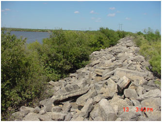 Lake Stamford and Dam are located about twelve miles southeast of Haskell in the Haskell County, on Paint Creek, a tributary of the Clear Fork Brazos River which is a tributary to the Brazos River. The City of Stamford owns and operates the Lake for municipal and industrial water supply and recreational purposes. Authorization to the lake (Permit No. 1542, Application No. 1650) was issued by the State of Texas on July 10, 1950. Construction of the dam started on July 14, 1951 and was completed in March of 1953. Deliberate impoundment of water began in June 1953. The dam is an earthfill embankment of 3,600 feet in length with a maximum height of 78 feet from the streambed. The top of the dam is at an elevation of 1,436.8 feet above mean sea level. The uncontrolled emergency spillway is located at the right end of the dam and is a cut channel over the natural ground with a crest at an elevation of 1,425.8 feet above mean sea level. The service spillway is located 900 feet to the left of the dam and is an excavated channel in rock with a crest at an elevation of 1,416.8 feet above mean sea level. According to the TWDB 1999 volumetric survey, the lake has a capacity of 51,573 acre feet and a surface area of 5,124 acres, at the conservation elevation of 1,416.8 feet above mean sea level. The dam controls a drainage area of about 360 square miles.