Sam Rayburn Reservoir (Neches River Basin)
 Sam Rayburn Dam and Reservoir is located approximately ten miles northwest of the town of Jasper, in the heart of the piney woods region of Southeast Texas on the Angelina River, the largest tributary of the Neches River. The Congress in 1955 authorized the construction of the dam for flood control, hydroelectric power generation, and conservation of water for municipal, industrial, agricultural, and recreational uses as the second element of the U.S. Army Corps of Engineers development plan for the Neches River Basin.
The construction began in 1956, and deliberate impoundment of water began in March, 1965. The full conservation pool was reached in 1966. When the construction of the dam began, the project was known as "McGee Bend Dam and Reservoir", because of its' location immediately upstream from McGee Bend on the river. In September, 1963, the 88th Congress adopted a special resolution changing the name to "Sam Rayburn Dam and Reservoir", in honor of the recently deceased Speaker of the U.S. House of Representatives Sam Rayburn, a long-time champion of soil and water conservation, including the promotion on the Lake Texoma project and so on. Dedication ceremonies were held on May 8, 1965, with President Lyndon B. Johnson delivering the principal address by telephone from the White House.
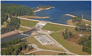
The dam consists of an earth embankment, concrete power-intake structure, and flood-control outlet works located near the right end of the dam. The total length is 19,430 feet with a height of 120 feet and the top of the dam at elevation of 193.6 feet above mean sea level. Maximum design flood stage can reach to 183 feet above mean sea level. Based available data from U.S. Army Corps of Engineers, at crest of emergency spillway, elevation 176 feet above mean sea level, the reservoir can store up to 4,442,400 acre feet of water encompassing a surface area of 153,800 acres. At top of flood control pool, elevation 173 feet above mean sea level, the reservoir can hold 3,997,600 acre feet of water encompassing a surface area of about 142,700 acres. According to TWDB 2004 volumetric survey, the reservoir encompasses 112,590 surface acres and contains a total of 2,876,033 acre-feet of water at power pool elevation (164.4 ft above mean sea level). The dam controls a drainage area of approximately 3,449 square miles. It is the fourth largest reservoir in or shared with Texas (largest within Texas) by total storage capacity.