Ray Roberts Lake (Trinity River Basin)
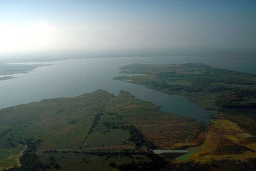 Ray Roberts Lake (also known as Aubrey Lake) is located between the cities of Sanger and Aubrey in Denton County, on the Elm Fork, a tributary of the Trinity River. Ray Roberts Lake inundates parts of Denton, Cooke, and Grayson Counties. Ray Roberts Lake is owned by the U.S. Government and operated by the U.S. Army Corps of Engineers, Fort Worth District.
The reservoir was built primarily for water supply for the cities of Dallas and Denton. Ray Roberts Lake was authorized by the Rivers and Harbors Act of 1965. State's Water Right Permit was issued in 1975 for the Ray Robert Lake. The proposed lake was renamed in 1980 for U.S. Congressman Ray Roberts (1913-1993). Construction on Ray Roberts Dam began on May 31, 1982. The dam was completed and deliberate impoundment of water began on June 30, 1987. The 15,250-foot dam has a maximum height above streambed of 141 feet. The top of the dam is at the elevation of 655 feet above mean sea level. The uncontrolled emergency spillway is located near the right end of the dam and is broadcrested on the natural ground measuring about 100 feet in length at crest elevation of 645.5 feet above mean sea level. The maximum designed water surface can reach the elevation of 658.8 feet above mean sea level. At the top of the flood control pool, at an elevation of 640.5 feet above mean sea level, the lake covers 36,900 acres and stores 1,064,600 acre feet of water. According to the 2008 TWDB survey, at the top of the conservation pool, at an elevation of 632.5 feet above mean sea level, the lake covers 28,646 acres and stores 788.490 acre feet of water. The dam controls a drainage area of about 692 square miles.