Pat Mayse Lake (Red River Basin)
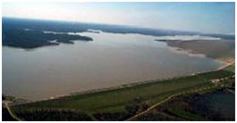 Pat Mayse Lake, named after Mrs. Pat Mayse, a tireless advocate for the lake, is located on Sanders Creek, a tributary of the Red River. It is approximately twelve miles north of Paris in Lamar County, Texas. According to the data source from Lamar County website on Pat Mayse Lake, "Groundbreaking of the new lake was in October 1964. Mrs. Pat Mayse joined Congressman Wright Patman and U.S. Army Corps of Engineer officials for the groundbreaking. Construction began on March 9, 1965; closure of the embankment occurred on November 29, 1966; and the diversion opening in the outlet works was closed in August 1967.
The U.S. Army Corps of Engineers began impounding water into the newly constructed reservoir and the project was placed in full flood control operation on September 28, 1967. The top of conservation pool was reached on April 20, 1968. The earthfill embankment is 7,080 feet long, excluding the spillway; rises 96 feet above the streambed; and has a top width of 32 feet".
Based on pertinent data from U. S. Army Corps of Engineers (Tulsa District), the top of dam is at the elevation of 488.5 feet above mean sea level and the uncontrolled emergency spillway crest is at the elevation of 477 feet above mean sea level. The capacity at top of flood control pool is 189,100 acre feet encompassing a surface area of 7,680 acres at the elevation of 460.5 feet above mean sea level. According to TWDB 2008 volumetric survey, Pat Mayse Lake has a storage capacity of 117,844 acre-feet and encompasses 5,638 acres at the top of conservation pool, elevation of 451.0 feet above mean sea level (NGVD29). The dam controls a drainage area of approximately 175 square miles.