Lake Nacogdoches (Neches River Basin)
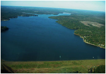 Lake Nacogdoches (also known as Loco Dam) is located on Loco Bayou, a tributary of the Angelina River which is a tributary of the Neches River, ten miles west of Nacogdoches off FM 225. The City of Nacogdoches is the controlling authority. Primary uses are municipal water supply and recreation. Construction of the dam began in June of 1975. Deliberate impoundment occurred on May 4, 1976. Talon Construction Company of Addison, TX was the general contractor.
The lake was formally placed on line as a water source for the city in September 1977. The dam's structure is a rolled earth embankment, approximately 4,350 feet in length and 50 feet tall above the natural streambed. The top of the dam is at elevation, 303.0 feet above mean sea level. Maximum design water surface may reach to 298.5 feet above mean sea level. The emergency spillway (earth cut channel) is located at the west end of the embankment and is approximately 500 feet wide with a crest elevation of 286.0 feet above mean sea level. The service spillway is a concrete "Morning Glory" designed drop inlet. The 25 foot diameter crest is at elevation 279.0 ft. mean sea level. According to TWDB 1994 volumetric survey, the lake has a storage capacity of 39,523 acre-feet, encompassing a surface area of 2,212 acres, at its conservation pool elevation 279.0 feet above mean sea level. The dam controls a drainage area of approximately 89 square miles.