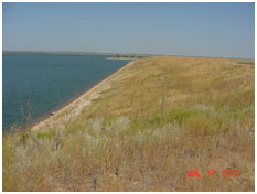
Lake Kemp (Red River Basin)
 Lake Kemp, named after Joseph Alexander Kemp (1861–1930), is located on the Big Wichita River north of Seymour in Baylor County, off US 183 about forty miles from City of Wichita Falls, Texas. After successfully financing the construction of Wichita Lake in 1901, Mr. Kemp continued to work for a constitutional amendment allowing the sale of municipal bonds to finance the construction of irrigation systems.
After thirty-six years of speaking publicly, chairing groups, and making numerous trips to Austin and Washington, D.C., he succeeded and an amendment was eventually passed and funds were made available to construct two dams (Diversion and Kemp) on the Wichita River to irrigate and control floods in the area3. Construction of Lake Kemp Dam began on February 25, 1922 and was completed on August 25, 1923. The impoundment started on October 1, 1922. In May 1969, the U.S. Army Corps of Engineers redesigned the dam to raise the conservation pool and increased the storage of Lake Kemp.
The project became operational in October of 1972 when the new outlet works were completed. The reservoir is jointly owned by the City of Wichita Falls and the Wichita County Water Improvement District No.2 (WCWID#2). The WCWID#2 manages the conservation pool storage and the U.S. Army Corps of Engineers manages flood control storage. Lake Kemp was built for flood control and water supply and is operated with Lake Diversion as a system. Per U.S. Army Corps of Engineers, at top of flood control pool elevation, 1,156 feet above mean sea level, the lake can store 567,900 acre feet of water encompassing a surface area of approximately 27,440 acres. The elevation of top of dam is at 1,183 feet above mean sea level with an uncontrolled spillway at 1,160 feet above mean sea level. From 2004 to 2010, operations were allowed at the higher conservation pool elevation (1,145.5 feet above mean sea level) during months of April through October when demands were higher for irrigation. The volume of Lake Kemp is heavily affected by its sedimentation, which is estimated at a rate of approximately 890 acre-feet/year. The sediment also made water in upstream portions of the lake unavailable below elevations 1,138 feet above mean sea level. According to TWDB 2006 volumetric survey, the lake can store 245,434 acre-feet of water encompassing a surface area of 15,357 acres, at its conservation pool elevation, 1,144 feet above mean sea level. The dam controls a drainage area of approximately 2,086 square miles.
3 - Data source: Texas State Historical Association on Lake Kemp