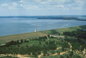
Grapevine Dam and Lake (Trinity River Basin)
 Grapevine Lake and Dam is located in the north Grapevine near the border between Denton County and Tarrant County, on Denton Creek, a tributary of the Elm Fork of the Trinity River. It was built, owned, and operated by the U.S. Army Corps of Engineers. The U.S. Congress approved the River & Harbors Act of 1945 on March 2nd, 1945 and provided for the construction of many reservoirs for the purposes of both flood control and navigation along the Trinity River floodplain including the Grapevine Lake.
Construction of the dam started in January 1948 and was completed on June 6, 1952. Deliberate impoundment of water began on July 3, 1952. The 12,850-foot dam consists of an earth-fill embankment 137 feet above the streambed with an elevation of 588 feet above mean sea level at the top and a 500-foot uncontrolled concrete spillway with a crest at an elevation of 560 feet above mean sea level. Designed maximum water surface is at an elevation of 581 feet above mean sea level. According to data from USACE, the Lake could hold 425,500 acre feet of water encompassing a surface area of 12,710 acres at the flood pool elevation of 560 feet above mean sea level. According to the TWDB 2010 volumetric survey, the top of the conservation pool is at an elevation of 535 feet above mean sea level, the lake will cover 6,707 acres and store 163,064 acre feet water. The dam controls about 695 square miles of drainage area.