Lake Corpus Christi (Nueces River Basin)
 Lake Corpus Christi (also known as Wesley E. Seale Dam, Lake Lovenskiold or Lake Mathis) is located four miles west of Mathis, at the intersection of the Live Oak, San Patricio, and Jim Wells county lines, on the Nueces River. The reservoir is owned and operated by the city of Corpus Christi for municipal water supply and recreational purposes. Construction started on La Fruta Dam in 1927 and was completed in 1929. The impoundment of water formed by La Fruta Dam was called Lake Lovenskiold. A partial failure of La Fruta Dam occurred in late 1930.
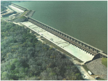
Reconstruction of the dam utilized much of the original structure and was completed in 1934. On November 19, 1955 construction started on the new dam at a site located just downstream of the existing La Fruta Dam. The new dam was named after Wesley E. Seale, a former mayor and city councilman for the City of Corpus Christi and Chairman of the Lower Nueces River Water Supply District. The dam was completed on April 26, 1958 and at that time impoundment of water began. Before the old La Fruta Dam was inundated, the tainter gates were removed and part of the embankment was breached. Wesley E. Seale Dam is an earthfill and concrete structure, with a total length (including spillways) of 5,980 feet and a height of 75 feet. The top of the dam is at elevation of 106.0 feet above mean sea level. There are two spillways, the north (emergency) spillway and the south (service) spillway. The north spillway is equipped with 33 gates, and the south spillway has 27 gates. The 33 gates are set with top at elevation of 94.3 feet above mean sea level, while the 27 gates are set with top at elevation of 93.8 feet above mean sea level. Sill of all gates (or crest of both spillways) is at elevation of 88.0 feet above mean sea level.
According to 2012 TWDB survey, the reservoir has a capacity of 254,732 acre feet encompassing a surface area of 18,700 acres at the conservation pool elevation of 94.0 feet above mean sea level. The drainage area above the dam is approximately 16,656 square miles.