Cedar Creek Reservoir (Trinity River Basin)
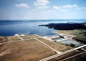 Cedar Creek Reservoir (also known as Joe B. Hogsett Dam) is located about three miles northeast of Trinidad in Henderson and Kaufman Counties, on Cedar Creek, a tributary of the Trinity River. The project is owned and operated by the Tarrant Regional Water District for municipal water supply, flood control, and recreational purposes. Construction of the reservoir started in April 1961 and was completed in 1965.
Deliberate impoundment of water began July 2, 1965. Freese, Nichols and Endress Consulting Engineers designed the project and the general contractor was S. A. Construction Company. The dam structure is a rolled earthfill embankment. The dam is approximately 17,539 feet long and rises 91 feet above the natural streambed, with the top at an elevation of 340 feet above mean sea level. Designed at 100-Year Flood Elevation of 323.5 feet above mean sea level. The emergence spillway is controlled by 8 tainter gates at the elevations of 325 and 302 (top and sill of the gate at closed position) feet above mean sea level. There are also 2 bascule automatic gates mainly for service purposes at elevations of 322.5 and 314 (top and sill of the gate at closed position) feet above mean sea level. According to the TWDB 2005 survey, the reservoir has a total storage capacity of 644,785 acre-feet and a surface area of 32,873 acres at operating elevation of 322 feet above mean sea level (NGVD 1929). The drainage area above the dam is 1,007 square miles.