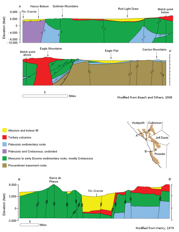
West Texas Bolsons Aquiferscross-section
Aquifer Facts
- Aquifer type: unconfined
- Area of aquifer: 1,898 square miles
- Proportion of aquifer with groundwater conservation districts: 81 percent
- Number of counties containing the aquifer: 4
Summary
The West Texas Bolsons Aquifer is a minor aquifer located in several basins, or bolsons, in far west Texas. The aquifer occurs as water-bearing, basin-fill deposits as much as 3,000 feet thick. It is composed of eroded materials that vary depending on the mountains bordering the basins and the manner in which the sediments were deposited. Sediments range from the fine-grained silt and clay of lake deposits to the coarse-grained volcanic rock and limestone of alluvial fans. Freshwater saturated thickness averages about 580 feet.
Groundwater quality varies depending on the basin, ranging from freshwater, containing less than 1,000 milligrams per liter of total dissolved solids, to slightly to moderately saline water, containing between 1,000 and 4,000 milligrams per liter of total dissolved solids. Groundwater in the central and southern regions of the aquifer commonly exceeds maximum contaminant level for arsenic, fluoride, gross alpha radiation, or nitrate-N. The northern regions of the aquifer are more likely to exceed the maximum contaminant level for total dissolved solids.
Groundwater is used for irrigation and livestock throughout the area and for municipal supply in the cities of Presidio, Sierra Blanca, Valentine, and Van Horn.
Reports
| ID | Date | Type | Description |
|---|---|---|---|
| Texas Aquifers Study | 12/31/2016 | Legislative Report | Texas Aquifers Study: Groundwater Quantity, Quality, Flow, and Contributions to Surface Water |
| R-380 | 7/1/2011 | TWDB numbered report | Aquifers of Texas |
| R-356 | 12/1/2001 | TWDB numbered report | Aquifers of West Texas |
| R-256 | 8/1/1980 | TWDB numbered report | Availability of Fresh and Slightly Saline Ground Water in the Basins of Westernmost Texas |
| R-364 | 8/1/2005 | TWDB numbered report | The Hydrogeology of Hudspeth County, Texas |
| R-016 | 2/1/1966 | TWDB numbered report | Water-Level Data from Observation Wells in Culberson, Jeff Davis, Presidio, and Brewster Counties, Texas |
| AA06-01 | 6/10/2008 | Aquifer assessment | Water-level decline scenarios for the Capitan Reef Complex, Marathon, Rustler, Presidio-Redford Bolson, Edwards-Trinity (Plateau), and Diablo Plateau aquifers in Groundwater Management Area 4 |
| GT10-028 | 7/29/2010 | GAM task | Predictive simulations for the Igneous and West Texas Bolsons aquifers in Groundwater Management Area 4 |
| GT10-026 | 6/24/2010 | GAM task | Predictive simulation for the Igneous and West Texas Bolsons aquifers in Groundwater Management Area 4 |
| GR10-003 | 6/29/2010 | GAM run | Predictive simulations for the Igneous and West Texas Bolsons aquifers in Groundwater Management Area 4 |
| GR09-025 | 1/11/2011 | GAM run | Predictive simulation for the Igneous and West Texas Bolsons aquifers in Groundwater Management Area 4 |
| GR08-088_MP | 3/17/2009 | GAM run - Management Plan | Management plan information for Presidio County UWCD |
| GR08-029_MP | 5/28/2008 | GAM run - Management Plan | Management plan information for Jeff Davis County UWCD |
| GR08-024 | 12/19/2008 | GAM run | Predictive simulations for the Igneous and West Texas Bolsons aquifers in Groundwater Management Area 4 |
| GR06-032 | 5/2/2007 | GAM run | Predictive simulation for the Igneous and West Texas Bolsons aquifers in Groundwater Management Area 4 |
| GR06-017 | 7/18/2006 | GAM run | Predictive simulation for the Igneous and West Texas Bolsons aquifers in Groundwater Management Area 4 |
| GR06-004 | 3/8/2006 | GAM run | Predictive simulation for the Igneous and West Texas Bolsons aquifers in Jeff Davis and Presidio counties |
| GR06-003 | 3/8/2006 | GAM run | Predictive simulation for the West Texas Bolsons Aquifer in Culberson County GCD |
| GR06-002_MP | 3/1/2006 | GAM run - Management Plan | Management plan information for Culberson County GCD |
| GR05-040 | 2/7/2006 | GAM run | Predictive simulation for the Igneous and West Texas Bolsons aquifers in Jeff Davis and Presidio counties |
| GR11-018_MP | 1/23/2012 | GAM run - Management Plan | Culberson County GCD Management Plan |
| GR12-023_MP | 8/10/2012 | GAM run - Management Plan | Management plan data for Jeff Davis County UWCD |
| GR12-026_MP | 3/21/2013 | GAM run - Management Plan | Management plan data for Presidio County UWCD |
| GT13-028_TERS | 1/15/2014 | GAM task - Total Estimated Recoverable Storage | Total Estimated Recoverable Storage for aquifers in Groundwater Management Area 4 |
| GR19-007_MP | 3/18/2019 | GAM run - Management Plan | Management plan information for Presidio County UWCD |
| GR16-030_MAG_Add | 6/24/2020 | GAM run - MAG | Culberson County Groundwater Conservation District Modeled Available Groundwater for the West Texas Bolsons Aquifer |
| GR23-010_MP | 06/07/2023 | GAM run - Management Plan | Management plan information for Jeff Davis County UWCD |