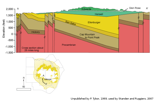
Hickory Aquifercross-section
Aquifer Facts
- Aquifer type: confined and unconfined
- Area of outcrop: 272 square miles
- Area of subsurface: 8,317 square miles
- Proportion of aquifer with groundwater conservation districts: 85 percent
- Number of counties containing the aquifer: 19
Summary
The Hickory Aquifer is a minor aquifer in the central part of the state that consists of the water-bearing parts of the Hickory Sandstone Member. The Hickory Member is a mixture of terrestrial and marine sandstones, siltstones, and mudstones. The Hickory Aquifer reaches a maximum thickness of 480 feet, and freshwater saturated thickness averages about 350 feet.
Groundwater is mostly fresh with less than 1,000 milligrams per liter of total dissolved solids. Excess iron in the upper portion of the aquifer may result in poor-tasting water and may exceed drinking water standards. Additionally, naturally occurring radioactivity may exceed the state�s primary drinking standards. Radionuclides are derived from the Precambrian granite rocks in the Llano Uplift.
The groundwater is used for irrigation throughout its extent and for municipal supply in the cities of Brady, Mason, and Fredericksburg.
Reports
| ID | Date | Type | Description |
|---|---|---|---|
| Texas Aquifers Study | 12/31/2016 | Legislative Report | Texas Aquifers Study: Groundwater Quantity, Quality, Flow, and Contributions to Surface Water |
| B-6004 | 8/1/1960 | Groundwater bulletin | Geology and Ground-Water Resources of Hays County, Texas |
| R-057 | 9/1/1967 | TWDB numbered report | Occurrence and Quality of Ground Water in Coleman County, Texas |
| R-235 | 7/1/1979 | TWDB numbered report | Occurrence, Availability, and Chemical Quality of Ground Water in the Edwards Plateau Region of Texas |
| R-174 | 7/1/1973 | TWDB numbered report | Ground-Water Resources of Blanco County, Texas |
| R-360 | 2/9/2004 | TWDB numbered report | Conference Proceedings: Aquifers of the Edwards Plateau |
| R-346 | 3/1/1996 | TWDB numbered report | The Paleozoic and Related Aquifers of Central Texas |
| R-339 | 8/1/1992 | TWDB numbered report | Evaluation of Ground-Water Resources of the Paleozoic and Cretaceous Aquifers in the Hill Country of Central Texas |
| B-6519 | 8/1/1965 | Groundwater bulletin | Ground-Water Conditions in Menard County, Texas |
| B-6017 | 2/1/1961 | Groundwater bulletin | Ground-Water Geology of the Hickory Sandstone Member of the Riley Formation, McCulloch County, Texas |
| AA08-07 | 8/31/2010 | Aquifer assessment | Desired future condition scenarios for the Hickory Aquifer in Groundwater Management Area 7 |
| AA10-05 | 9/10/2010 | Aquifer assessment | Desired future condition scenarios for the Hickory Aquifer in Groundwater Management Area 7 |
| GMA8_DFC_05 | 4/27/2011 | DFC submission | Desired future conditions for the Blossom, Brazos River Alluvium, Edwards (Balcones Fault Zone), Ellenburger-San Saba, Hickory, Marble Falls, Nacatoch, Trinity, and Woodbine aquifers |
| CR-1004831116 | 7/11/2012 | Contract report | Aquifer Test and Related Well Information from Public Water Supply Wells in Groundwater Management Area 8 |
| R-380 | 7/1/2011 | TWDB numbered report | Aquifers of Texas |
| GT13-030_TERS | 10/2/2013 | GAM task - Total Estimated Recoverable Storage | Total Estimated Recoverable Storage for aquifers in Groundwater Management Area 7 |
| GT13-032_TERS | 10/2/2013 | GAM task - Total Estimated Recoverable Storage | Total Estimated Recoverable Storage for aquifers in Groundwater Management Area 9 |
| GT13-031_TERS | 1/15/2014 | GAM task - Total Estimated Recoverable Storage | Total Estimated Recoverable Storage for aquifers in Groundwater Management Area 8 |
| GR16-006_MP | 6/21/2016 | GAM run - Management Plan | Management plan information for Central Texas GCD |
| GR16-019_MP | 9/17/2016 | GAM run - Management Plan | Management plan information for Headwaters GCD |
| GR17-028_MP | 3/27/2017 | GAM run - Management Plan | Management plan information for Menard County UWD |
| GR17-005_MP | 5/26/2017 | GAM run - Management Plan | Management plan information for Lipan-Kickapoo Water Conservation District |
| GR17-009_MP | 1/30/2018 | GAM run - Management Plan | Management plan information for Hill Country UWCD |
| GR13-010_MP | 6/4/2018 | GAM run - Management Plan | Management plan information for Hickory UWCD no.1 |
| GR18-007_MP | 7/13/2018 | GAM run - Management Plan | Management plan information for Hickory UWCD #1 |
| GR18-015_MP | 9/28/2018 | GAM run - Management Plan | Management plan information for Kimble County GCD |
| GR19-011_MP | 2/27/2019 | GAM run - Management Plan | Management plan information for Cow Creek GCD |
| GR19-005_MP | 3/15/2019 | GAM run - Management Plan | Management plan information for Saratoga UWCD |
| GR19-027_MP | 12/13/2019 | GAM run - Management Plan | Management plan information for Southwestern Travis County GCD |
| GR19-026_MP | 1/9/2020 | GAM run - Management Plan | Management plan information for Hays Trinity GCD |
| GR21-003_MP | 4/20/2021 | GAM run - Management Plan | Management plan information for Headwaters GCD |
| GR21-004_MP | 10/11/2021 | GAM run - Management Plan | Management plan information for Menard County UWCD |
| GR21-005_MP | 10/11/2021 | GAM run - Management Plan | Management plan information for Central Texas GCD |
| GR22-013_MP | 11/8/2022 | GAM run - Management Plan | Management plan information for Lipan-Kickapoo WCD |
| GR23-019_MP | 08/16/2023 | GAM run - Management Plan | Management plan information for Hickory UWCD #1 |
| GR23-017_MP | 08/30/2023 | GAM run - Management Plan | Management plan information for Blanco-Padernales GCD |
| Contract-8-REC-003 | February 1988 | TWDB contract report | Evaluation of the Hickory Aquifer and Its Relationship to Katemcy Creek and Its Major Tributaries for Beneficial Artificial Recharge, McCulloch and Mason Counties, Texas |
| GR23-004_MP | 05/31/2023 | GAM run - Management Plan | Management plan information for Hill Country UWCD |
| GR23-026_MP | 01/19/2024 | GAM run - Management Plan | Management plan information for Kimble County GCD |
| GR24-008_MP | 09/12/2024 | GAM run - Management Plan | Management plan information for Cow Creek GCD |