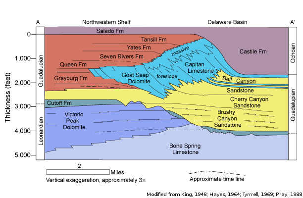
Capitan Reef Complex Aquifercross-section
Aquifer Facts
- Aquifer type: unconfined
- Area of aquifer: 1,850 square miles
- Proportion of aquifer with groundwater conservation districts: 62 percent
- Number of counties containing the aquifer: 8
Summary
The Capitan Reef Complex Aquifer is a minor aquifer located in Culberson, Hudspeth, Jeff Davis, Brewster, Pecos, Reeves, Ward, and Winkler counties. It is exposed in mountain ranges of Far West Texas; elsewhere it occurs in the subsurface. The aquifer is composed of as much as 2,360 feet of massive, cavernous dolomite and limestone. Water-bearing formations include the Capitan Limestone, Goat Seep Dolomite, and most of the Carlsbad facies of the Artesia Group, including the Grayburg, Queen, Seven Rivers, Yates, and Tansill formations. Water is contained in solution cavities and fractures that are unevenly distributed within these formations. Water from the Capitan Reef Complex Aquifer is thought to contribute to the base flow of San Solomon Springs in Reeves County.
Overall, the aquifer contains water of marginal quality, yielding small to large quantities of slightly saline to saline groundwater containing 1,000 to greater than 5,000 milligrams per liter of total dissolved solids. Water of the freshest quality, with total dissolved solids between 300 and 1,000 milligrams per liter, is present in the west near areas of recharge where the reef rock is exposed in several mountain ranges.
Although most of the groundwater pumped from the aquifer in Texas is used for oil reservoir flooding in Ward and Winkler counties, a small amount is used to irrigate salt-tolerant crops in Pecos, Culberson, and Hudspeth counties.
Reports
| ID | Date | Type | Description |
|---|---|---|---|
| Texas Aquifers Study | 12/31/2016 | Legislative Report | Texas Aquifers Study: Groundwater Quantity, Quality, Flow, and Contributions to Surface Water |
| R-317 | 1/1/1990 | TWDB numbered report | Evaluation of Ground-Water Resources in Parts of Loving, Pecos, Reeves, Ward and Winkler Counties, Texas |
| HA-08 | 1/1/1997 | Hydrologic atlas | Water Quality in the Capitan Reef Aquifer |
| R-356 | 12/1/2001 | TWDB numbered report | Aquifers of West Texas |
| AA06-01 | 6/10/2008 | Aquifer assessment | Water-level decline scenarios for the Capitan Reef Complex, Marathon, Rustler, Presidio-Redford Bolson, Edwards-Trinity (Plateau), and Diablo Plateau aquifers in Groundwater Management Area 4 |
| AA09-08 | 9/21/2010 | Aquifer assessment | Desired future condition scenarios for the Capitan Reef Complex Aquifer in Groundwater Management Area 4 |
| R-380 | 7/1/2011 | TWDB numbered report | Aquifers of Texas |
| CR-0804830794 | 9/1/2009 | Contract report | Capitan Reef Complex Structure and Statigraphy |
| GT13-027_TERS | 9/19/2013 | GAM task - Total Estimated Recoverable Storage | Total Estimated Recoverable Storage for aquifers in Groundwater Management Area 3 |
| GT13-030_TERS | 10/2/2013 | GAM task - Total Estimated Recoverable Storage | Total Estimated Recoverable Storage for aquifers in Groundwater Management Area 7 |
| GT13-028_TERS | 1/15/2014 | GAM task - Total Estimated Recoverable Storage | Total Estimated Recoverable Storage for aquifers in Groundwater Management Area 4 |
| GR18-001_MP | 5/10/2018 | GAM run - Management Plan | Management plan information for Reeves County GCD |
| GR19-008_MP | 2/27/2019 | GAM run - Management Plan | Management plan information for Brewster County GCD |
| GR19-021_MP | 2/20/2020 | GAM run - Management Plan | Management plan information for Middle Pecos GCD |
| GR23-001_MP | 5/10/2023 | GAM run - Management Plan | Management plan information for Reeves County GCD |