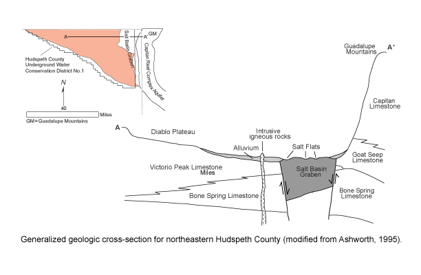
Bone Spring-Victorio Peak Aquifercross-section
Aquifer Facts
- Aquifer type: unconfined
- Area of aquifer: 713 square miles
- Proportion of aquifer with groundwater conservation districts: 100 percent
- Number of counties containing the aquifer: 1
Summary
The Bone Spring-Victorio Peak Aquifer is a minor aquifer located in northern Hudspeth County. The principal water-bearing units in the aquifer are the Bone Spring and Victorio Peak limestones, both Permian in age. The formations produce groundwater from solution cavities developed along joints and fracture planes. Groundwater flows regionally toward the east-northeast through the aquifer, although a significant amount of groundwater also flows into the Dell Valley area from the Sacramento Mountains in New Mexico along a set of northwest-southeast-trending fractures.
Water is generally slightly saline, with total dissolved solids of 1,000 to 3,000 milligrams per liter. In the Dell Valley area, total dissolved solids increase to 3,000 to 10,000 milligrams per liter. Water quality in this area appears to be controlled by two mechanisms: groundwater flowing through the aquifer system and dissolving minerals along its flow path and irrigation water percolating down through the soil zone.
Significant amounts of groundwater have been pumped and are being pumped from the aquifer in the Dell Valley area. Since the late 1940s, pumping has been the principal means of discharge for the aquifer. Pumping to the south and west of the Dell Valley area is limited to scattered wells used for livestock or domestic purposes.
Reports
| ID | Date | Type | Description |
|---|---|---|---|
| Texas Aquifers Study | 12/31/2016 | Legislative Report | Texas Aquifers Study: Groundwater Quantity, Quality, Flow, and Contributions to Surface Water |
| R-356 | 12/1/2001 | TWDB numbered report | Aquifers of West Texas |
| R-344 | 1/1/1995 | TWDB numbered report | Ground-Water Resources of the Bone Spring-Victorio Peak Aquifer in the Dell Valley Area, Texas |
| R-364 | 8/1/2005 | TWDB numbered report | The Hydrogeology of Hudspeth County, Texas |
| GT10-006 | 9/3/2010 | GAM task | Predictive simulations for the Bone Spring-Victorio Peak Aquifer in Groundwater Management Area 4 |
| GR11-020_MP | 6/1/2012 | GAM run - Management Plan | Management Plan for Hudspeth County UWCD No. 1 |
| R-380 | 7/1/2011 | TWDB numbered report | Aquifers of Texas |
| GT13-028_TERS | 1/15/2014 | GAM task - Total Estimated Recoverable Storage | Total Estimated Recoverable Storage for aquifers in Groundwater Management Area 4 |
| GR23-014_MP | 06/06/2023 | GAM run - Management Plan | Management plan information for Hudspeth County UWCD No. 1 |