Hueco-Mesilla Bolsons Aquifercross-section
Aquifer Facts
- Aquifer type: unconfined
- Area of aquifer: 1,376 square miles
- Proportion of aquifer with groundwater conservation districts: 0 percent
- Number of counties containing the aquifer: 2
Summary
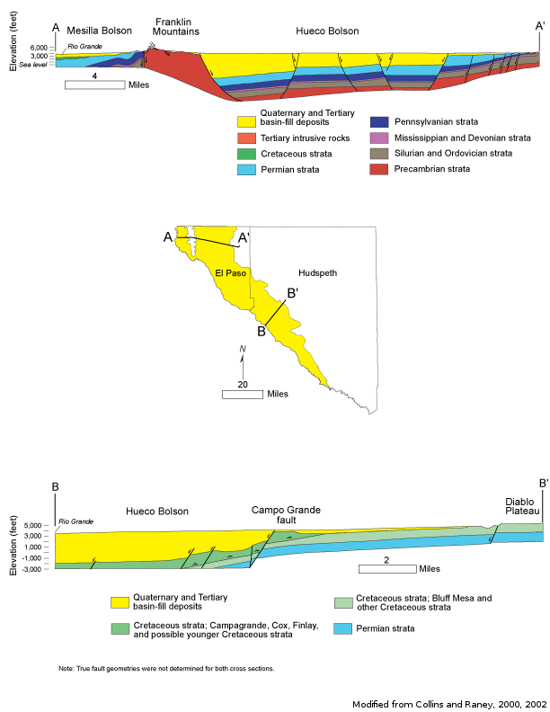
The Hueco-Mesilla Bolsons Aquifer, located east and west of the Franklin Mountains in Far West Texas, is recognized as a major aquifer in Texas. The Hueco Bolson is considered the southern portion of the Tularosa-Hueco Basin. The northern portion of the aquifer, the Tularosa Basin, lies entirely in the state of New Mexico. The Hueco and Mesilla Bolsons also extend under the Rio Grande River into Mexico. The aquifer is composed of basin-fill deposits of silt, sand, gravel, and clay in two basins, or bolsons: the Hueco Bolson, which has a maximum thickness of 9,000 feet, and the Mesilla Bolson, which has a maximum thickness of 2,000 feet. Although the Hueco and Mesilla bolsons share similar geology, very little water travels between them. The area of the Hueco-Mesilla Bolsons Aquifer does not connect with any other major or minor aquifer in Texas and there are no flows between the Hueco-Mesilla Bolsons Aquifer and any other major or minor aquifer in Texas.
Fresh groundwater stored in the aquifer system beneath El Paso and Ciudad Juarez is bordered by regions of brackish to saline groundwater. The upper portion of the Hueco Bolson contains fresh to slightly saline water, ranging from less than 1,000 to 3,000 milligrams per liter of total dissolved solids. The Mesilla Bolson also contains fresh to saline water, ranging from less than 1,000 to 10,000 or more milligrams per liter of total dissolved solids. Its salinity typically increases to the south and in the shallower parts of the aquifer. In both aquifers, water level declines have contributed to higher salinity.
The Hueco Bolson is the principal aquifer for the El Paso area and Ciudad Juarez in Mexico − nearly 90 percent of the water pumped from the Mesilla and the Hueco bolsons in Texas is used for public supply. Water levels have declined several hundred feet primarily owing to municipal pumping in the Hueco Bolson up to the late 1980s. Since that time, however, observation wells indicate that water levels have stabilized.
Reports
| ID | Date | Type | Description |
|---|---|---|---|
| Texas Aquifers Study | 12/31/2016 | Legislative Report | Texas Aquifers Study: Groundwater Quantity, Quality, Flow, and Contributions to Surface Water |
| R-356 | 12/1/2001 | TWDB numbered report | Aquifers of West Texas |
| R-256 | 8/1/1980 | TWDB numbered report | Availability of Fresh and Slightly Saline Ground Water in the Basins of Westernmost Texas |
| R-028 | 9/1/1966 | TWDB numbered report | Analog Model Study of the Hueco Bolson Near El Paso, Texas |
| R-153 | 8/1/1972 | TWDB numbered report | Development of Ground-Water in the El Paso District, Texas |
| R-364 | 8/1/2005 | TWDB numbered report | The Hydrogeology of Hudspeth County, Texas |
| R-246 | 6/1/1980 | TWDB numbered report | Ground-Water Development in the El Paso Region, Texas, with Emphasis on the Resources of the Lower El Paso Valley |
| R-300 | 8/1/1987 | TWDB numbered report | Summary of Hydrologic Information in the El Paso, Texas, Area with Emphasis on Ground-Water Studies, 1903-80 |
| R-324 | 3/1/1990 | TWDB numbered report | Evaluation of Ground-Water Resources in El Paso County, Texas |
| R-380 | 7/1/2011 | TWDB numbered report | Aquifers of Texas |