Region 14 Upper Rio Grande Flood Planning Region
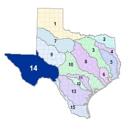 The Upper Rio Grande River tracks the US-Mexico border from El Paso to Val Verde County. By far the largest of the flood planning regions, Region 14 traverses the Trans-Pecos ecoregion and Big Bend National Park. The region reaches its eastern border as the Upper Rio Grande River enters the International Amistad Reservoir at the confluence of the Devil�s River and the upper Rio Grande River. This region is home to five major lakes and reservoirs including two international reservoirs and Lake Balmorhea at Balmorhea State Park.
For a detailed map of Region 14, please visit the Texas Geographic Information Office (TxGIO) Flood Planning Regions Map Collection.
Go to Region 14 Upper Rio Grande RFPG External Host Website
Population Estimate (2019): 936,558
Approximate Area: 43,204 square miles
Approximate Stream Miles: 24,559
Approximate NFIP Claims (1975-2019): $5,265,002
Counties Represented:
- Andrews*
- Brewster
- Crane
- Crockett*
- Culberson
- Ector*
- Edwards*
- El Paso
- Hudspeth
- Jeff Davis
- Loving
- Midland*
- Pecos
- Presidio
- Reagan*
- Reeves
- Schleicher*
- Sutton*
- Terrell
- Upton*
- Val Verde*
- Ward
- Winkler
*indicates this county is partially within this RFPG and is also represented by at least one other RFPG
Major Cities (Population greater than 25,000):
- El Paso
- Socorro
Major Lakes & Reservoirs:
- Imperial Reservoir
- International Amistad Reservoir
- Lake Balmorhea
- Red Bluff Reservoir
- San Esteban Lake
Ecoregions of Texas Represented:
- Edwards Plateau
- High Plains
- South Texas Plains
- Trans-Pecos
Regional Flood Planning Group Meeting Minutes & Updates
Please see the RFPG Meeting Schedule webpage for information on the past and upcoming meetings.
Contacts
Planning Group Sponsor Contact: Rio Grande Council of Governments, Annette Guitierrez, (915) 533-0998
Planning Group Chair: Omar Martinez, (915) 540-6271
TWDB Flood Planner: Nick Collins, (512) 475-1705