Region 13 Nueces Flood Planning Region
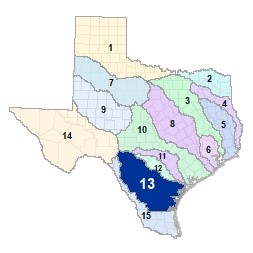 The Nueces River originates on the Edwards Plateau in Central Texas in Edwards and Real Counties. The Sabinal, Atascosa, Leona, and Frio Rivers and their numerous tributaries all feed the Nueces on its way to Nueces and Corpus Christi Bays. Extending south from Corpus Christi, a large portion of the Nueces-Rio Grande Coastal Basin, containing Corpus Christi Bay, Corpus Christi Ship Channel, Oso Bay, and Baffin Bay, is also located in the Nueces Flood Planning Region. This region includes six major reservoirs and crosses five ecoregions of Texas, including most of the South Texas Plains ecoregion.
For a detailed map of Region 13, please visit the Texas Geographic Information Office (TxGIO) Flood Planning Regions Map Collection.
Go to Region 13 Nueces RFPG External Host Website
Population Estimate (2019): 782,528
Approximate Area: 24,094 square miles
Approximate Stream Miles: 17,044
Approximate NFIP Claims (1975-2019): $270,467,109
Counties Represented:
- Aransas*
- Atascosa*
- Bandera*
- Bee
- Bexar*
- Brooks*
- Calhoun
- Dimmit*
- Duval
- Edwards*
- Frio
- Goliad*
- Jim Hogg*
- Jim Wells
- Karnes*
- Kenedy*
- Kerr*
- Kinney*
- Kleberg
- La Salle
- Live Oak
- Maverick*
- McMullen
- Medina*
- Nueces
- Real*
- Refugio*
- San Patricio
- Uvalde
- Webb*
- Wilson*
- Zavala
*indicates this county is partially within this RFPG and is also represented by at least one other RFPG
Major Cities (Population greater than 25,000):
- Corpus Christi
- Kingsville
Major Lakes & Reservoirs:
- Barney M Davis Reservoir
- Choke Canyon Reservoir
- Lake Corpus Christi Reservoir
- Tailing Ponds
- Tailing Ponds No. 2
- Upper Nueces Lake
Ecoregions of Texas Represented:
- Blackland Prairie
- Edwards Plateau
- Gulf Prairies
- Post Oak Savanah
- South Texas Plains
Regional Flood Planning Group Meeting Minutes & Updates
Please see the Region 13 Nueces RFPG Website for information on past and upcoming meetings. Upcoming meetings will also be posted on the TWDB�s RFPG Meeting Schedule webpage.
Contacts
Planning Group Sponsor Contact: Nueces River Authority, Travis Pruski, (210) 710-0617
Planning Group Chair: Barbara Canales, (361) 658-8209
TWDB Contact: Luz Lumb, (512) 475-1578