TWDB Home > Groundwater > Groundwater Data> Tools and Resources
Tools and Educational Resources
Welcome to our resource page dedicated to empowering you with the knowledge and tools needed to understand and utilize groundwater data effectively.
Jump to a Section
Groundwater Monitoring and Modeling
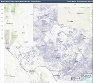
Groundwater Data Viewer
Interactive map used to locate wells and view groundwater data across Texas.
Water Data for Texas
The TWDB, in partnership with its cooperators, continues to install and monitor automatic water level recorders in observation wells throughout the state.

Subsidence Prediction
Tool used to identify and characterize areas within Texas' major and minor aquifers that are susceptible to land subsidence related to groundwater pumping.
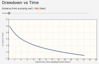
Interactive Drawdown
This tool aids in understanding the effects of pumping at select locations where aquifer properties are either known or can be estimated with some degree of certainty.
Conditions Report
View current and past reports of water conditions around the state.
Planning and Management Tools
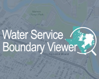
Texas Water Service Boundary Viewer
This interactive map viewer allows the public to view, search, download and print retail water service boundaries of public water systems across Texas. The viewer also provides access to related reports including historical water use data and Texas Commission on Environmental Quality public water system information.

Interactive State Water Plan
This interactive website allows users to take an up-close look at state water plan data thematically and at discrete levels not found in teh electronic version of the plan.

Historical Water Use Summary and Data Dashboard
This interactive data dashboard displays historical water use survey and estimate data.

ASR and AR Suitability
StoryMap and interactive web map for the statewide survey identifying the relative suitability of Texas' major and minor aquifers for aquifer storage and recover (ASR) or aquifer recharge (AR) projects.

Projected Drought
This dashboard provides information on conditions across the state, including rainfall, temperature, streamflow, and soil moisture as well as various drought indices and U.S. Drought Monitor status.

Texas FLOOD Viewer
An interactive mapping application for viewing current conditions and up-to-date information for flooding in your area.

Interactive State Flood Plan Viewer
This Interactive State Flood Plan Viewer complements Texas' inaugural 2024 State Flood Plan. The viewer allows stakeholders to view and download the extensive dataset generated by the statewide flood planning program, including flood risk and recommended flood risk reduction solutions.

TexMesonet
View and access data from selected weather stations and rain gauges throughout Texas.
Educational Resources
Educational Videos
Browse our selection of groundwater videos.