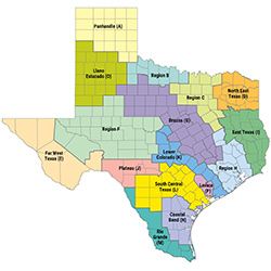
Regional Water Planning Groups
 The TWDB hosts a region-specific webpage for each planning group that contains a general description of the region, the list of counties that lie within the regional planning area boundary, and meeting updates. To view a region of interest, please click the region's name in the list. You may also click on the link below to find which region you are located in.
Search by address to find your Regional Water Planning Region
- Region A Panhandle
- Region B
- Region C
- Region D North East Texas
- Region E Far West Texas
- Region F
- Region G Brazos
- Region H
- Region I East Texas
- Region J Plateau
- Region K Lower Colorado
- Region L South Central Texas
- Region M Rio Grande
- Region N Coastal Bend
- Region O Llano Estacado
- Region P Lavaca
For a map of all 16 regional water planning areas, please see one of the following:
- Large format regional water planning area map
- Small format regional water planning area map
- Maps of individual Regional Water Planning Areas
Regional Water Planning Group Contacts
The TWDB compiles information provided by each of the regional water planning groups for voting and non-voting members, and Planning Group Administrators. This information is delineated by regional water planning region in the reports below and is updated approximately every other month.