Region E Planning Group
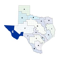 Stretching from the city of El Paso at the Texas-New Mexico state line over salt flats and southeastward toward the sparsely populated mountainous Big Bend country and the Pecos River, the Far West Texas Planning Area includes seven counties that lie within the Rio Grande Basin. The largest economic sectors in the region are agriculture, agribusiness, manufacturing, tourism, wholesale and retail trade, government, and military. About 96 percent of the region's residents reside in El Paso County, where the population density is 760 persons per square mile. The other six counties have a density of 1.1 persons per square mile.
For a detailed map of Region E, please visit the Texas Geographic Information Office (TxGIO)Regional Water Planning Area Map Collection
Far West Texas (Region E) RWPG External Website
Region E Counties
- Brewster
- Culberson
- El Paso
- Hudspeth
- Jeff Davis
- Presidio
- Terrell
Meeting Minutes & Updates
Meeting Minutes: Visit the "Meetings" link on Region E's External Website for official planning group meeting minutes.
Next Meeting: Please see the Upcoming Regional Water Planning Group Meetings webpage for information on the next Region E meeting.
Region E Bylaws
Region E Water Plans
Projections Data
Region E Related Links
TWDB Contacts for Region E
For regional water planning assistance, please contact Heather Rose, Region E Planner.
For regional water project development assistance, please contact Theresa Finch, Team 1 Manager.