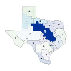
Region G Planning Group
 Stretching from the piney woods of Grimes County in the southeast to the rolling plains of Kent County in the northwest, the Brazos G Regional Water Planning Area includes all or parts of 37 counties. Over 90 percent of the region lies within the Brazos River Basin, with the Brazos River being the region's primary source of water. The largest economic sectors in the region are service, manufacturing, and retail trade. Major cities in the region include Abilene, Bryan, College Station, Killeen, Round Rock, Temple, and Waco.
For a detailed map of Region G, please visit the Texas Geographic Information Office (TxGIO)Regional Water Planning Area Map Collection
Brazos (Region G) RWPG External Website
Region G Counties
- Bell
- Brazos
- Bosque
- Burleson
- Callahan
- Comanche
- Coryell
- Eastland
- Erath
- Falls
- Fisher
- Grimes
- Hamilton
- Haskell
- Hill
- Hood
- Johnson
- Jones
- Kent
- Knox
- Lampasas
- Lee
- Limestone
- McLennan
- Milam
- Nolan
- Palo Pinto
- Robertson
- Shackelford
- Somervell
- Stephens
- Stonewall
- Taylor
- Throckmorton
- Washington
- Williamson (partial)
- Young (partial)
Meeting Minutes & Updates
Meeting Minutes: Visit the "Meeting Materials & Audio" link on Region G's External Website for official planning group meeting minutes.
Next Meeting: Please see the Upcoming Regional Water Planning Group Meetings webpage for information on the next Region G meeting.
Region G Bylaws
Region G Water Plans
Projections Data
Region G Related Links
- Brazos River Authority (BRA)
- Groundwater Management Areas - GMAs 6, 7, 8, 12, and 14 overlap Region G
TWDB Contacts for Region G
For regional water planning assistance, please contact Brittany Condry, Region G Planner.
For regional water project development assistance, please contact Candice DeLello, Team 2 Manager.