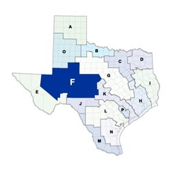
Region F Planning Group
 Located in West Texas, the Region F Regional Water Planning Area is located in the Edwards Plateau. Reeves County forms the western boundary and Brown County the eastern boundary of the 32-county region. Intersected by the Pecos River to the south and the Colorado River to the north, most of the region is located in the upper portion of the Colorado River Basin and Pecos portion of the Rio Grande Basin; a small portion is in the Brazos Basin. The major cities in the region include Midland, Odessa, and San Angelo. The region's economy relies heavily on healthcare and social assistance, mining, manufacturing, and oil and gas employment sectors.
For a detailed map of Region F, please visit the Texas Geographic Information Office (TxGIO)Regional Water Planning Area Map Collection
Region F RWPG External Website
Region F Counties
- Andrew
- Borden
- Brown
- Coke
- Coleman
- Concho
- Crane
- Crockett
- Ector
- Glasscock
- Howard
- Irion
- Kimble
- Loving
- Martin
- Mason
- McCulloch
- Menard
- Midland
- Mitchell
- Pecos
- Reagan
- Reeves
- Runnels
- Schleicher
- Scurry
- Sterling
- Sutton
- Tom Green
- Upton
- Ward
- Winkler
Meeting Minutes & Updates
Meeting Minutes: Visit the "Meetings" link on Region F's External Website for official planning group meeting minutes.
Next Meeting: Please see the Upcoming Regional Water Planning Group Meetings webpage for information on the next Region F meeting.
Region F Bylaws
Region F Water Plans
Projections Data
Region F Related Links
- Colorado River Municipal Water District (CRMWD)
- Upper Colorado River Authority (UCRA)
- Groundwater Management Areas - GMAs 2, 3, 7, and 8 overlap Region F
TWDB Contacts for Region F
For regional water planning assistance, please contact Noah Powell, Region F Planner.
For regional water project development assistance, please contact Theresa Finch, Team 1 Manager.