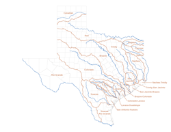
River Basins
 A brief summary of the major river basins in Texas is provided below. Click on the river basin name for additional information related to that basin.
There are eight designated coastal basins in Texas: the Neches-Trinity, Trinity-San Jacinto, San Jacinto-Brazos, Brazos-Colorado, Colorado-Lavaca, Lavaca-Guadalupe, San Antonio-Nueces, and Nueces-Rio Grande. Each coastal basin is named according to the major river basins that bound them. For example, the Nueces-Rio Grande Coastal Basin is bounded on the north by the Nueces River Basin and on the south by the Rio Grande Basin. Each coastal basin is also bounded by a bay or other outlet to the Gulf of Mexico.
| River basin | Basin area | River length | Average flow (acre-feet per year) |
||
|---|---|---|---|---|---|
| Total (square miles) |
in Texas (square miles) |
Total (miles) |
in Texas (miles) |
||
| Brazos | 45,573 | 42,865 | 840 | 840 | 6,074,000 |
| Canadian | 47,705 | 12,865 | 906 | 213 | 196,000 |
| Colorado | 42,318 | 39,428 | 865 | 865 | 1,904,000 |
| Cypress | 3,552 | 2,929 | 90 | 75 | 493,700 |
| Guadalupe | 5,953 | 5,953 | 409 | 409 | 1,422,000 |
| Lavaca | 2,309 | 2,309 | 117 | 117 | 277,000 |
| Neches | 9,937 | 9,937 | 416 | 416 | 4,323,000 |
| Nueces | 16,700 | 16,700 | 315 | 315 | 539,700 |
| Red | 93,450 | 24,297 | 1,360 | 695 | 3,464,000 |
| Rio Grande | 182,215 | 49,387 | 1,896 | 889 | 645,500 |
| Sabine | 9,756 | 7,570 | 360 | 360 | 5,864,000 |
| San Antonio | 4,180 | 4,180 | 238 | 238 | 562,700 |
| San Jacinto | 3,936 | 3,936 | 85 | 85 | 1,365,000 |
| Sulphur | 3,767 | 3,580 | 222 | 200 | 932,700 |
| Trinity | 17,913 | 17,913 | 550 | 550 | 5,727,000 |