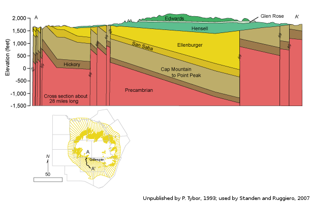
Ellenburger-San Saba Aquifercross-section
Aquifer Facts
- Aquifer type: confined and unconfined
- Area of outcrop: 1,152 square miles
- Area of subsurface: 4,279 square miles
- Proportion of aquifer with groundwater conservation districts: 80 percent
- Number of counties containing the aquifer: 16
Summary
The Ellenburger-San Saba Aquifer is a minor aquifer that is found in parts of 16 counties in the Llano Uplift area of Central Texas. The aquifer consists of the Tanyard, Gorman, and Honeycut formations of the Ellenburger Group and the San Saba Limestone Member of the Wilberns Formation. The aquifer consists of a sequence of limestone and dolomite that crop out in a circular pattern around the Llano Uplift and dip radially into the subsurface away from the center of the uplift to depths of approximately 3,000 feet. Regional block faulting has significantly compartmentalized the aquifer. The maximum thickness of the aquifer is about 2,700 feet.
Water occurs in fractures, cavities, and solution channels and is commonly under confined conditions. The aquifer is highly permeable in places, as indicated by wells that yield as much as 1,000 gallons per minute. Numerous springs issue from the aquifer, maintaining the baseflow of streams in the area.
Groundwater in the Ellenburger-San Saba Aquifer is generally very good and usually has less than 1,000 milligrams per liter of total dissolved solids. Total dissolved solids increase down-dip and radially outward from the Llano Uplift, centered in Llano County. Elevated concentrations of radionuclides also occur in the aquifer, mostly in the northern part of the aquifer.
Most of the groundwater is used for municipal purposes, and the remainder for irrigation and livestock. A large portion of water flowing from San Saba Springs, which is the water supply for the city of San Saba, is thought to be from the Ellenburger-San Saba and Marble Falls aquifers.
Reports
| ID | Date | Type | Description |
|---|---|---|---|
| Texas Aquifers Study | 12/31/2016 | Legislative Report | Texas Aquifers Study: Groundwater Quantity, Quality, Flow, and Contributions to Surface Water |
| B-6310 | 12/1/1973 | Groundwater bulletin | Reconnaissance Investigation of the Ground-Water Resources of the Brazos River Basin, Texas |
| R-046 | 5/1/1967 | TWDB numbered report | Occurrence and Quality of Ground Water in Brown County, Texas |
| R-057 | 9/1/1967 | TWDB numbered report | Occurrence and Quality of Ground Water in Coleman County, Texas |
| R-235 | 7/1/1979 | TWDB numbered report | Occurrence, Availability, and Chemical Quality of Ground Water in the Edwards Plateau Region of Texas |
| R-174 | 7/1/1973 | TWDB numbered report | Ground-Water Resources of Blanco County, Texas |
| R-360 | 2/9/2004 | TWDB numbered report | Conference Proceedings: Aquifers of the Edwards Plateau |
| R-346 | 3/1/1996 | TWDB numbered report | The Paleozoic and Related Aquifers of Central Texas |
| R-339 | 8/1/1992 | TWDB numbered report | Evaluation of Ground-Water Resources of the Paleozoic and Cretaceous Aquifers in the Hill Country of Central Texas |
| B-6519 | 8/1/1965 | Groundwater bulletin | Ground-Water Conditions in Menard County, Texas |
| CR-1004831116 | 7/11/2012 | Contract report | Aquifer Test and Related Well Information from Public Water Supply Wells in Groundwater Management Area 8 |
| R-380 | 7/1/2011 | TWDB numbered report | Aquifers of Texas |
| GT13-030_TERS | 10/2/2013 | GAM task - Total Estimated Recoverable Storage | Total Estimated Recoverable Storage for aquifers in Groundwater Management Area 7 |
| GT13-032_TERS | 10/2/2013 | GAM task - Total Estimated Recoverable Storage | Total Estimated Recoverable Storage for aquifers in Groundwater Management Area 9 |
| GT13-031_TERS | 1/15/2014 | GAM task - Total Estimated Recoverable Storage | Total Estimated Recoverable Storage for aquifers in Groundwater Management Area 8 |
| GR16-006_MP | 6/21/2016 | GAM run - Management Plan | Management plan information for Central Texas GCD |
| GR16-019_MP | 9/17/2016 | GAM run - Management Plan | Management plan information for Headwaters GCD |
| GR17-028_MP | 3/27/2017 | GAM run - Management Plan | Management plan information for Menard County UWD |
| GR17-009_MP | 1/30/2018 | GAM run - Management Plan | Management plan information for Hill Country UWCD |
| GR18-003_MP | 4/6/2018 | GAM run - Management Plan | Management plan information for Blanco-Pedernales GCD |
| GR13-010_MP | 6/4/2018 | GAM run - Management Plan | Management plan information for Hickory UWCD no.1 |
| GR18-007_MP | 7/13/2018 | GAM run - Management Plan | Management plan information for Hickory UWCD #1 |
| GR18-015_MP | 9/28/2018 | GAM run - Management Plan | Management plan information for Kimble County GCD |
| GR19-005_MP | 3/15/2019 | GAM run - Management Plan | Management plan information for Saratoga UWCD |
| GR21-003_MP | 4/20/2021 | GAM run - Management Plan | Management plan information for Headwaters GCD |
| GR21-004_MP | 10/11/2021 | GAM run - Management Plan | Management plan information for Menard County UWCD |
| GR21-005_MP | 10/11/2021 | GAM run - Management Plan | Management plan information for Central Texas GCD |
| GR22-013_MP | 11/8/2022 | GAM run - Management Plan | Management plan information for Lipan-Kickapoo WCD |
| GR23-019_MP | 08/16/2023 | GAM run - Management Plan | Management plan information for Hickory UWCD #1 |
| GR23-017_MP | 08/30/2023 | GAM run - Management Plan | Management plan information for Blanco-Padernales GCD |
| GR23-004_MP | 05/31/2023 | GAM run - Management Plan | Management plan information for Hill Country UWCD |
| GR23-026_MP | 01/19/2024 | GAM run - Management Plan | Management plan information for Kimble County GCD |
| GR24-008_MP | 09/12/2024 | GAM run - Management Plan | Management plan information for Cow Creek GCD |