Dockum Aquifercross-section
Aquifer Facts
- Aquifer type: confined and unconfined
- Area of outcrop: 3,525 square miles
- Area of subsurface: 22,030 square miles
- Proportion of aquifer with groundwater conservation districts: 55 percent
- Number of counties containing the aquifer: 46
Summary
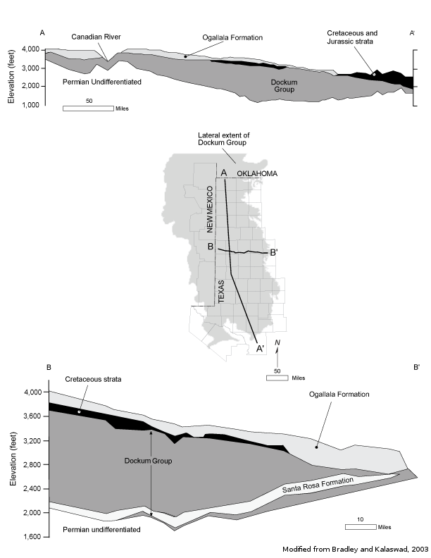
The Dockum Aquifer is a minor aquifer found in the northwest part of the state and is part of the High Plains Aquifer System, which also consists of the Ogallala and Rita Blanca aquifers. It is defined stratigraphically by the Dockum Group, which is composed of sandstones, conglomerates, mudstones, and siltstones. The Dockum Aquifer is overlain by the Ogallala Aquifer except in the outcrop areas along the Canadian and Colorado Rivers where the Ogallala has been eroded away. Permian System red-bed shales underlie the Dockum Aquifer, forming a no-flow lower boundary.
The water quality in the aquifer is generally poor and very hard. Naturally occurring radioactivity from uranium present within the aquifer has resulted in gross alpha radiation in excess of the state's primary drinking water standard in about 25 percent of Dockum Aquifer wells. Radium-226 and -228 also occur in amounts above acceptable standards. Nitrate is present at concentrations exceeding primary drinking water standards in about 10 percent of the wells, mostly in the outcrop areas, where it is associated with agricultural operations. Dockum Aquifer groundwater exceeds secondary drinking water standards for chloride, fluoride, iron, sulfate, and total dissolved solids in about one-third of the wells tested, primarily as the result of the evaporite minerals present in the Dockum Group and underlying formations of the Permian Basin.
Groundwater from the aquifer is used for irrigation, municipal water supply, and oil field waterflooding operations, particularly in the southern High Plains.
Reports
| ID | Date | Type | Description |
|---|---|---|---|
| Texas Aquifers Study | 12/31/2016 | Legislative Report | Texas Aquifers Study: Groundwater Quantity, Quality, Flow, and Contributions to Surface Water |
| R-116 | 5/1/1970 | TWDB numbered report | Quantity and Chemical Quality of Low Flow in the Prairie Dog Town Fork Red River near Wayside, Texas, February 6-9,1968 |
| R-315 | 11/1/1989 | TWDB numbered report | Evaluation of Ground-Water Resources in Dallam County, Texas |
| R-359 | 12/1/2003 | TWDB numbered report | The Groundwater Resources of the Dockum Aquifer in Texas |
| R-317 | 1/1/1990 | TWDB numbered report | Evaluation of Ground-Water Resources in Parts of Loving, Pecos, Reeves, Ward and Winkler Counties, Texas |
| B-6010 | 11/1/1960 | Groundwater bulletin | Geology and Ground-Water Resources of Hale County, Texas |
| R-015 | 2/1/1966 | TWDB numbered report | Ground-Water Resources of Gaines County, Texas |
| GMA1_DFC_02 | 6/3/2010 | DFC submission | Desired future conditions for the Blaine and Dockum aquifers |
| R-356 | 12/1/2001 | TWDB numbered report | Aquifers of West Texas |
| B-6310 | 12/1/1973 | Groundwater bulletin | Reconnaissance Investigation of the Ground-Water Resources of the Brazos River Basin, Texas |
| B-5604 | 3/1/1956 | Groundwater bulletin | Ground-Water Resources of the Crane Sandhills, Crane County, Texas |
| R-047 | 5/1/1967 | TWDB numbered report | Occurrence and Quality of Ground Water in Crockett County, Texas |
| R-050 | 6/1/1967 | TWDB numbered report | Ground-Water Resources of Mitchell and Western Nolan Counties, Texas |
| R-360 | 2/9/2004 | TWDB numbered report | Conference Proceedings: Aquifers of the Edwards Plateau |
| R-337 | 3/1/1992 | TWDB numbered report | Evaluation of Water Resources in Parts of the Rolling Prairies Region of North-Central Texas |
| R-330 | 7/1/1991 | TWDB numbered report | Evaluation of Ground-Water Resources in the Southern High Plains of Texas |
| R-078 | 5/1/1968 | TWDB numbered report | Ground-Water Resources of Upton County, Texas |
| R-145 | 4/1/1972 | TWDB numbered report | Water Wells and Ground-Water Chemical Analysis Data, Reagan County, Texas |
| R-146 | 4/1/1972 | TWDB numbered report | Water Well and Ground-Water Chemical Analysis Data, Irion County, Texas |
| R-166 | 3/1/1973 | TWDB numbered report | Ground-Water Resources of Coke County, Texas |
| R-167 | 4/1/1973 | TWDB numbered report | Ground-Water Resources of Hall and Eastern Briscoe Counties, Texas |
| GR11-009_MP | 6/24/2011 | GAM run - Management Plan | Management plan information for High Plains UWCD No. 1 |
| GT11-010 | 6/14/2011 | GAM task | Total pumping estimates for the Ogallala, Edwards-Trinity (High Plains), and Dockum aquifers in High Plains UWCD No. 1 |
| GR11-003_MP | 7/29/2011 | GAM run - Management Plan | Management plan information for Santa Rita UWCD |
| GR10-026_MP | 8/24/2010 | GAM run - Management Plan | Management plan information for Sterling County UWCD |
| GT10-025 | 6/10/2010 | GAM task | Predictive simulations for the Dockum Aquifer |
| GR10-007_MP | 7/20/2010 | GAM run - Management Plan | Management plan information for Gateway GCD |
| GR10-001 | 6/21/2010 | GAM run | Predictive simulations for the Dockum Aquifer in Groundwater Management Area 7 |
| GR09-018_MP | 7/24/2009 | GAM run - Management Plan | Management plan information for Llano Estacado UWCD |
| GR09-017_MP | 7/24/2009 | GAM run - Management Plan | Management plan information for Clear Fork UWCD |
| GR09-014 | 9/21/2010 | GAM run | Predictive simulation for the Dockum Aquifer in Groundwater Management Area 1 |
| GR09-014_Add | 9/21/2010 | GAM run | Predictive simulations for the Dockum Aquifer in Groundwater Management Area 1 |
| GR09-013_MP | 8/6/2009 | GAM run - Management Plan | Management plan information for Wes-Tex GCD |
| GR09-007_MP | 3/17/2009 | GAM run - Management Plan | Management plan information for Garza County UWCD |
| GR09-006_MP | 3/17/2009 | GAM run - Management Plan | Management plan information for High Plains UWCD No. 1 |
| GR09-003_MP | 1/23/2009 | GAM run - Management Plan | Management plan information for High Plains UWCD No. 1 |
| GR09-002_MP | 1/23/2009 | GAM run - Management Plan | Management plan information for Garza County UWCD |
| GR08-075_MP | 1/23/2009 | GAM run - Management Plan | Management plan information for Middle Pecos GCD |
| GR08-048_MP | 1/23/2009 | GAM run - Management Plan | Management plan information for Lone Wolf GCD |
| GR11-021_MP | 1/27/2012 | GAM run - Management Plan | Panhandle GCD Management Plan |
| GR12-007_MP | 6/13/2012 | GAM run - Management Plan | Permian Basin UWCD Management Plan |
| GR12-004_MP | 7/20/2012 | GAM run - Management Plan | Management plan data for Crockett County GCD |
| GR12-003_MP | 7/2/2012 | GAM run - Management Plan | Management plan data for North Plains GCD |
| R-380 | 7/1/2011 | TWDB numbered report | Aquifers of Texas |
| GR12-020_MP | 10/19/2012 | GAM run - Management Plan | Management plan data for Glasscock GCD |
| GR12-019_MP | 11/16/2012 | GAM run - Management Plan | Management plan data for Coke County UWCD |
| GR12-017_MP | 11/16/2012 | GAM run - Management Plan | Management plan data for Irion County WCD |
| GR12-003_MP_Ver2 | 9/17/2012 | GAM run - Management Plan | Revised management plan data for North Plains GCD |
| GR13-015_MP | 6/27/2013 | GAM run - Management Plan | Management Plan data for Lone Wolf GCD |
| GR13-021_MP | 8/28/2013 | GAM run - Management Plan | Management plan data for Garza County UWCD |
| GT13-025_TERS | 8/20/2013 | GAM task - Total Estimated Recoverable Storage | Total Estimated Recoverable Storage for aquifers in Groundwater Management Area 1 |
| GT13-026_TERS | 9/19/2013 | GAM task - Total Estimated Recoverable Storage | Total Estimated Recoverable Storage for aquifers in Groundwater Management Area 2 |
| GT13-027_TERS | 9/19/2013 | GAM task - Total Estimated Recoverable Storage | Total Estimated Recoverable Storage for aquifers in Groundwater Management Area 3 |
| GT13-029_TERS | 9/19/2013 | GAM task - Total Estimated Recoverable Storage | Total Estimated Recoverable Storage for aquifers in Groundwater Management Area 6 |
| GT13-030_TERS | 10/2/2013 | GAM task - Total Estimated Recoverable Storage | Total Estimated Recoverable Storage for aquifers in Groundwater Management Area 7 |
| GT13-042_TERS | 11/1/2013 | GAM task - Total Estimated Recoverable Storage | Total Estimated Recoverable Storage by county for aquifers in High Plains UWCD No. 1 |
| GR13-030_MP | 2/18/2014 | GAM run - Management Plan | Management plan data for Wes-Tex GCD |
| GR14-010_MP | 3/26/2014 | GAM run - Management Plan | Management Plan data for Middle Pecos GCD |
| GR14-002_MP | 6/30/2014 | GAM run - Management Plan | Management plan data for Llano Estacado UWCD |
| GR14-007_MP | 7/25/2014 | GAM run - Management Plan | Management plan data for Clear Fork GCD |
| GR14-013_MP | 4/10/2015 | GAM run - Management Plan | Management plan data for Gateway GCD |
| GT15-006_TERS | 12/17/2015 | GAM task - Total Estimated Recoverable Storage | Total Estimated Recoverable Storage for aquifers in Groundwater Management Area 1 |
| GR16-001_MP | 4/28/2016 | GAM run - Management Plan | Management plan information for Panhandle GCD |
| GR16-013_MP | 8/31/2016 | GAM run - Management Plan | Management plan information for Permian Basin UWCD |
| GR17-012_MP | 3/28/2017 | GAM run - Management Plan | Management plan information for Sterling County UWCD |
| GR17-022_MP | 3/28/2017 | GAM run - Management Plan | Management plan information for Crockett County GCD |
| GR17-002_MP | 4/4/2017 | GAM run - Management Plan | Management plan information for Santa Rita UWCD |
| GR17-008_MP | 4/7/2017 | GAM run - Management Plan | Management plan information for North Plains GCD |
| GR18-001_MP | 5/10/2018 | GAM run - Management Plan | Management plan information for Reeves County GCD |
| GR18-009_MP | 5/25/2018 | GAM run - Management Plan | Management plan information for Mesa UWCD |
| GR17-014_MP | 6/1/2018 | GAM run - Management Plan | Management plan information for Coke County UWCD |
| GR18-022_MP | 2/11/2019 | GAM run - Management Plan | Management plan information for Glasscock GCD |
| GR19-004_MP | 2/27/2019 | GAM run - Management Plan | Management plan information for Lone Wolf GCD |
| GR19-002_MP | 3/1/2019 | GAM run - Management Plan | Management plan information for High Plains UWCD #1 |
| GR19-001_MP | 5/3/2019 | GAM run - Management Plan | Management plan information for Garza County UWCD |
| GR19-017_MP | 7/22/2019 | GAM run - Management Plan | Management plan information for Llano Estacado UWCD |
| GR19-023_MP | 10/1/2019 | GAM run - Management Plan | Management plan information for Gateway GCD |
| GR19-024_MP | 10/1/2019 | GAM run - Management Plan | Management plan information for Clear Fork GCD |
| GR19-021_MP | 2/20/2020 | GAM run - Management Plan | Management plan information for Middle Pecos GCD |
| GR22-005_MP | 5/23/2022 | GAM run - Management Plan | Management plan information for Permian Basin UWCD |
| GR22-015_MP | 1/13/2023 | GAM run - Management Plan | Management plan information for North Plains GCD |
| GR22-014_MP | 1/23/2023 | GAM run - Management Plan | Management plan information for Irion County WCD |
| GR22-016_MP | 1/31/2023 | GAM run - Management Plan | Management plan information for Sterling County UWCD |
| GR21-007_MAG | 2/28/2023 | GAM run - MAG | Modeled available groundwater estimates for the High Plains Aquifer System in Groundwater Management Area 1 |
| GR23-001_MP | 5/10/2023 | GAM run - Management Plan | Management plan information for Reeves County GCD |
| GR23-006_MP | 08/23/2023 | GAM run - Management Plan | Management plan information for Crockett County GCD |
| GR23-021_MP | 09/22/2023 | GAM run - Management Plan | Management plan information for Coke County UWCD |
| GR24-005_MP | 03/01/2024 | GAM run - Management Plan | Management plan information for Lone Wolf GCD |
| GR24-004_MP | 03/14/2024 | GAM run - Management Plan | Management plan information for Garza County UWCD |
| GR24-003_MP | 04/02/2024 | GAM run - Management Plan | Management plan information for Panhandle Groundwater Conservation District |
| GR24-006_MP | 05/20/2024 | GAM run - Management Plan | Management plan information for High Plains UWCD #1 |
| GR24-009_MP | 09/16/2024 | GAM run - Management Plan | Management plan information for Wes-Tex Groundwater Conservation District |
| GR24-010_MP | 10/28/2024 | GAM run - Management Plan | Management plan information for Glasscock GCD |
| GR24-011_MP | 11/15/2024 | GAM run - Management Plan | Management plan information for Santa Rita UWCD |