Blaine Aquifercross-section
Aquifer Facts
- Aquifer type: confined and unconfined
- Area of outcrop: 3,443 square miles
- Area of subsurface: 2,234 square miles
- Proportion of aquifer with groundwater conservation districts: 88 percent
- Number of counties containing the aquifer: 17
Summary
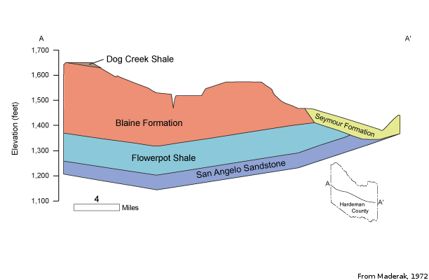
The Blaine Aquifer is a minor aquifer located at the east end of the High Plains in North Texas. The aquifer is part of the Permian Blaine Formation, which is composed of red silty shale, gypsum, anhydrite, salt, and dolomite. The formation consists of cycles of marine and non-marine sediments deposited in a broad, shallow sea that once covered the southwestern United States. Saturated thickness reaches 300 feet in the aquifer, but freshwater saturated thickness averages 137 feet. Groundwater occurs primarily in solution channels and caverns within the beds of anhydrite and gypsum and dissolution of these minerals contributes to the overall poor quality of the water.
Groundwater in the Blaine Aquifer is typically brackish. Although some wells contain slightly saline water, with total dissolved solids between 1,000 and 3,000 milligrams per liter, most contain moderately saline water, with total dissolved solids between 3,000 and 10,000 milligrams per liter, exceeding secondary drinking water standards for Texas. Sulfate values are also well in excess of the secondary drinking water standard of 300 milligrams per liter.
No significant water level declines have occurred in wells measured by the TWDB. Groundwater for domestic and livestock purposes is available from shallow wells over most of the aquifer's extent. Water is also used for some municipal, industrial, and irrigation purposes.
Reports
| ID | Date | Type | Description |
|---|---|---|---|
| Texas Aquifers Study | 12/31/2016 | Legislative Report | Texas Aquifers Study: Groundwater Quantity, Quality, Flow, and Contributions to Surface Water |
| B-6310 | 12/1/1973 | Groundwater bulletin | Reconnaissance Investigation of the Ground-Water Resources of the Brazos River Basin, Texas |
| R-337 | 3/1/1992 | TWDB numbered report | Evaluation of Water Resources in Parts of the Rolling Prairies Region of North-Central Texas |
| R-119 | 7/1/1970 | TWDB numbered report | Ground-Water Resources of Collingsworth County, Texas |
| R-161 | 11/1/1972 | TWDB numbered report | Ground-Water Resources of Hardeman County, Texas |
| R-167 | 4/1/1973 | TWDB numbered report | Ground-Water Resources of Hall and Eastern Briscoe Counties, Texas |
| R-215 | 4/1/1978 | TWDB numbered report | Occurrence, Quality, and Availability of Ground Water in Jones County, Texas |
| R-376 | 5/1/2011 | TWDB numbered report | Water Quality in the Blaine Aquifer |
| GT11-006 | 6/3/2011 | GAM task | Predictive simulations for the Seymour and Blaine aquifers in Groundwater Management Area 6 |
| GR10-021_MP | 7/22/2010 | GAM run - Management Plan | Management plan information for Rolling Plains GCD |
| GR10-007_MP | 7/20/2010 | GAM run - Management Plan | Management plan information for Gateway GCD |
| GR08-057_MP | 8/8/2008 | GAM run - Management Plan | Management plan information for Gateway GCD |
| GR08-054_MP | 8/1/2008 | GAM run - Management Plan | Management plan information for Mesquite GCD |
| GR08-044 | 11/7/2008 | GAM run | Predictive simulation for the Seymour and Blaine aquifers in Groundwater Management Area 6 |
| GR05-033 | 8/8/2005 | GAM run | Recharge information for the Seymour and Blaine aquifers in Knox, Baylor, and Haskell counties |
| GR05-017 | 5/16/2005 | GAM run | Saturated thickness maps for the Blaine and Seymour aquifers in Region A |
| GR04-022 | 3/4/2005 | GAM run | Volume in storage for Seymour and Blaine aquifers in Childress, Collingsworth, Hall, and Wheeler counties |
| GR11-021_MP | 1/27/2012 | GAM run - Management Plan | Panhandle GCD Management Plan |
| GR10-020_MAG | 6/22/2011 | GAM run - MAG | Managed available groundwater for the Blaine Aquifer in Groundwater Management Area 1 |
| R-380 | 7/1/2011 | TWDB numbered report | Aquifers of Texas |
| GR13-017_MP | 8/7/2013 | GAM run - Management Plan | Management plan data for Mesquite GCD |
| GT13-025_TERS | 8/20/2013 | GAM task - Total Estimated Recoverable Storage | Total Estimated Recoverable Storage for aquifers in Groundwater Management Area 1 |
| GT13-029_TERS | 9/19/2013 | GAM task - Total Estimated Recoverable Storage | Total Estimated Recoverable Storage for aquifers in Groundwater Management Area 6 |
| GT13-030_TERS | 10/2/2013 | GAM task - Total Estimated Recoverable Storage | Total Estimated Recoverable Storage for aquifers in Groundwater Management Area 7 |
| GR13-030_MP | 2/18/2014 | GAM run - Management Plan | Management plan data for Wes-Tex GCD |
| GR14-013_MP | 4/10/2015 | GAM run - Management Plan | Management plan data for Gateway GCD |
| GR14-009_MP | 5/6/2015 | GAM run - Management Plan | Management plan data for Rolling Plains GCD |
| GR16-001_MP | 4/28/2016 | GAM run - Management Plan | Management plan information for Panhandle GCD |
| GR18-010_MP | 5/3/2018 | GAM run - Management Plan | Management plan information for Mesquite GCD |
| GR19-012_MP | 6/13/2019 | GAM run - Management Plan | Management plan information for Wes-Tex GCD |
| GR19-020_MP | 7/26/2019 | GAM run - Management Plan | Management plan information for Rolling Plains GCD |
| GR19-023_MP | 10/1/2019 | GAM run - Management Plan | Management plan information for Gateway GCD |
| GR19-024_MP | 10/1/2019 | GAM run - Management Plan | Management plan information for Clear Fork GCD |
| GR21-007_MAG | 2/28/2023 | GAM run - MAG | Modeled available groundwater estimates for the High Plains Aquifer System in Groundwater Management Area 1 |
| GR23-013_MP | 07/14/2023 | GAM run - Management Plan | Management plan information for Mesquite GCD |
| GR24-003_MP | 04/02/2024 | GAM run - Management Plan | Management plan information for Panhandle Groundwater Conservation District |
| GR24-009_MP | 09/16/2024 | GAM run - Management Plan | Management plan information for Wes-Tex Groundwater Conservation District |