Seymour Aquifercross-section
Aquifer Facts
- Aquifer type: unconfined
- Area of aquifer: 3,374 square miles
- Proportion of aquifer with groundwater conservation districts: 62 percent
- Number of counties containing the aquifer: 25
Summary
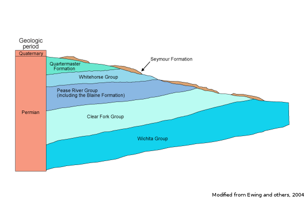
The Seymour Aquifer is a major aquifer extending across north central Texas. Water is contained in isolated pods of alluvial sediments as much as 360 feet thick composed of discontinuous beds of poorly sorted gravel, conglomerate, sand, and silty clay.
Water ranges from fresh to slightly saline, containing from approximately 100 to 3,000 milligrams per liter of total dissolved solids. However, moderately to very saline water exists in localized areas, with total dissolved solids ranging from 3,000 to more than 10,000 milligrams per liter. High nitrate concentrations are attributed to oxidation of soil organic nitrogen during initial cultivation followed by leaching of fertilizers on cultivated land. Excessive chloride and sulfate also occur throughout the aquifer. The Haskell-Knox counties pod of the aquifer has the highest probability for exceeding any primary drinking water standard.
Almost all of the groundwater pumped from the aquifer − 90 percent − is used for irrigation, with the remainder used primarily for municipal supply. It is reported that prior to significant land clearing and farming, the Seymour Aquifer was not a productive aquifer; the saturated thickness was inadequate to support pumping. Evapotranspiration losses decreased after the land was cleared, resulting in greater recharge and a gradual increase in the saturated thickness of the aquifer.
Reports
| ID | Date | Type | Description |
|---|---|---|---|
| Texas Aquifers Study | 12/31/2016 | Legislative Report | Texas Aquifers Study: Groundwater Quantity, Quality, Flow, and Contributions to Surface Water |
| B-6310 | 12/1/1973 | Groundwater bulletin | Reconnaissance Investigation of the Ground-Water Resources of the Brazos River Basin, Texas |
| B-6521 | 8/1/1965 | Groundwater bulletin | Investigation of Ground-Water Contamination, Rhineland Area, Knox County, Texas |
| R-224 | 10/1/1978 | TWDB numbered report | Occurrence, Quantity, and Quality of Ground Water in Taylor County, Texas |
| R-337 | 3/1/1992 | TWDB numbered report | Evaluation of Water Resources in Parts of the Rolling Prairies Region of North-Central Texas |
| R-226 | 12/1/1978 | TWDB numbered report | Th Seymour Aquifer Ground-Water Quality and Availability in Haskell and Knox Counties, Texas, Volumes 1 & 2 |
| R-119 | 7/1/1970 | TWDB numbered report | Ground-Water Resources of Collingsworth County, Texas |
| R-161 | 11/1/1972 | TWDB numbered report | Ground-Water Resources of Hardeman County, Texas |
| R-167 | 4/1/1973 | TWDB numbered report | Ground-Water Resources of Hall and Eastern Briscoe Counties, Texas |
| R-215 | 4/1/1978 | TWDB numbered report | Occurrence, Quality, and Availability of Ground Water in Jones County, Texas |
| R-218 | 7/1/1978 | TWDB numbered report | Occurrence and Quality of Ground Water in Baylor County, Texas |
| R-240 | 11/1/1979 | TWDB numbered report | Occurrence, Quality, and Quantity of Ground Water in Wilbarger County, Texas |
| GT11-006 | 6/3/2011 | GAM task | Predictive simulations for the Seymour and Blaine aquifers in Groundwater Management Area 6 |
| GR10-021_MP | 7/22/2010 | GAM run - Management Plan | Management plan information for Rolling Plains GCD |
| GR10-007_MP | 7/20/2010 | GAM run - Management Plan | Management plan information for Gateway GCD |
| GR09-017_MP | 7/24/2009 | GAM run - Management Plan | Management plan information for Clear Fork UWCD |
| GR08-057_MP | 8/8/2008 | GAM run - Management Plan | Management plan information for Gateway GCD |
| GR08-054_MP | 8/1/2008 | GAM run - Management Plan | Management plan information for Mesquite GCD |
| GR08-044 | 11/7/2008 | GAM run | Predictive simulation for the Seymour and Blaine aquifers in Groundwater Management Area 6 |
| GR05-038 | 1/27/2005 | GAM run | Predictive simulation for the Seymour Aquifer in Collingsworth County |
| GR05-033 | 8/8/2005 | GAM run | Recharge information for the Seymour and Blaine aquifers in Knox, Baylor, and Haskell counties |
| GR05-017 | 5/16/2005 | GAM run | Saturated thickness maps for the Blaine and Seymour aquifers in Region A |
| GR05-006 | 3/21/2005 | GAM run | Water budget for Hardeman and Foard counties in Tri-County GCD |
| GR05-002 | 3/1/2005 | GAM run | Water budget for Fisher County |
| GR04-022 | 3/4/2005 | GAM run | Volume in storage for Seymour and Baline aquifers in Childress, Collingsworth, Hall, and Wheeler counties |
| R-380 | 7/1/2011 | TWDB numbered report | Aquifers of Texas |
| GR13-017_MP | 8/7/2013 | GAM run - Management Plan | Management plan data for Mesquite GCD |
| GT13-025_TERS | 8/20/2013 | GAM task - Total Estimated Recoverable Storage | Total Estimated Recoverable Storage for aquifers in Groundwater Management Area 1 |
| GT13-026_TERS | 9/19/2013 | GAM task - Total Estimated Recoverable Storage | Total Estimated Recoverable Storage for aquifers in Groundwater Management Area 2 |
| GT13-029_TERS | 9/19/2013 | GAM task - Total Estimated Recoverable Storage | Total Estimated Recoverable Storage for aquifers in Groundwater Management Area 6 |
| GT13-030_TERS | 10/2/2013 | GAM task - Total Estimated Recoverable Storage | Total Estimated Recoverable Storage for aquifers in Groundwater Management Area 7 |
| GR14-007_MP | 7/25/2014 | GAM run - Management Plan | Management plan data for Clear Fork GCD |
| GR14-013_MP | 4/10/2015 | GAM run - Management Plan | Management plan data for Gateway GCD |
| GR14-009_MP | 5/6/2015 | GAM run - Management Plan | Management plan data for Rolling Plains GCD |
| GR18-010_MP | 5/3/2018 | GAM run - Management Plan | Management plan information for Mesquite GCD |
| GR19-020_MP | 7/26/2019 | GAM run - Management Plan | Management plan information for Rolling Plains GCD |
| GR19-023_MP | 10/1/2019 | GAM run - Management Plan | Management plan information for Gateway GCD |
| GR19-024_MP | 10/1/2019 | GAM run - Management Plan | Management plan information for Clear Fork GCD |
| GR21-007_MAG | 2/28/2023 | GAM run - MAG | Modeled available groundwater estimates for the High Plains Aquifer System in Groundwater Management Area 1 |
| GR23-013_MP | 07/14/2023 | GAM run - Management Plan | Management plan information for Mesquite GCD |