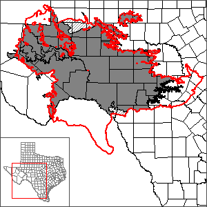
Edwards-Trinity (Plateau) and Pecos Valley Aquifers One Layer Groundwater Flow Model
The Texas Water Development Board improved the calibration of the Edwards-Trinity (Plateau) and Pecos Valley Aquifers GAM by converting the model from a two-layer to a one-layer model and by adjusting many of the input parameters including the model boundaries, model base and top elevations, recharge, hydraulic conductivity, anisotropy, and storage. The updated model was also calibrated for a longer period of time, 1930 through 2005, than the original model which was calibrated for the period 1980 through 2000. The updated model was constructed and run using a newer version of MODFLOW: MODFLOW-2000 versus MODFLOW-96 in the original model. Additionally, calibration was achieved using parameter estimation software, PEST, along with FORTRAN pre-processors.
Model Report
"Update of the Groundwater Availability Model for the Edwards-Trinity (Plateau) and Pecos Valley Aquifers of Texas." | erratum.
Model Files
Please see the GAM files download page for model files.
Other Resources
Please see the Edwards-Trinity (Plateau) and Pecos Valley aquifer pages and the Edwards-Trinity (Plateau) and Pecos Valley Aquifers GAM page for other reports and publications.
For model runs see the GMA 3, GMA 4, GMA 7, and GMA 9 pages.