Locating a Water Well Report
TWDB Home > Groundwater > Groundwater Data> Locating a Water Well Report
Click here for a printable version of these procedures.
Before you begin you will need at a minimum the following information:
- When the well was drilled, or at least an approximate date or year
- Name of property owner at the time the well was drilled
Note: If previous property owners are unknown, the deed history may be obtained from the county�s appraisal district, many of which have online search capabilities on their websites.
Additional information that may help with your search:
- Well depth (depth to the bottom of the well)
- Drilling company
The drill date is important because there are separate databases for wells drilled prior to 2003 and wells drilled from 2003 to the present. Texas water well reports drilled since 2003 are submitted electronically and stored in the Submitted Drillers Reports Database. Prior to 2003, well reports were submitted as paper copies to the Texas Commission on Environmental Quality (TCEQ). These paper copies have since been scanned and can now be found in the TCEQ Water Well Report Viewer.
Find a well report for a well drilled from 2003 to the present:
Locate well report by address
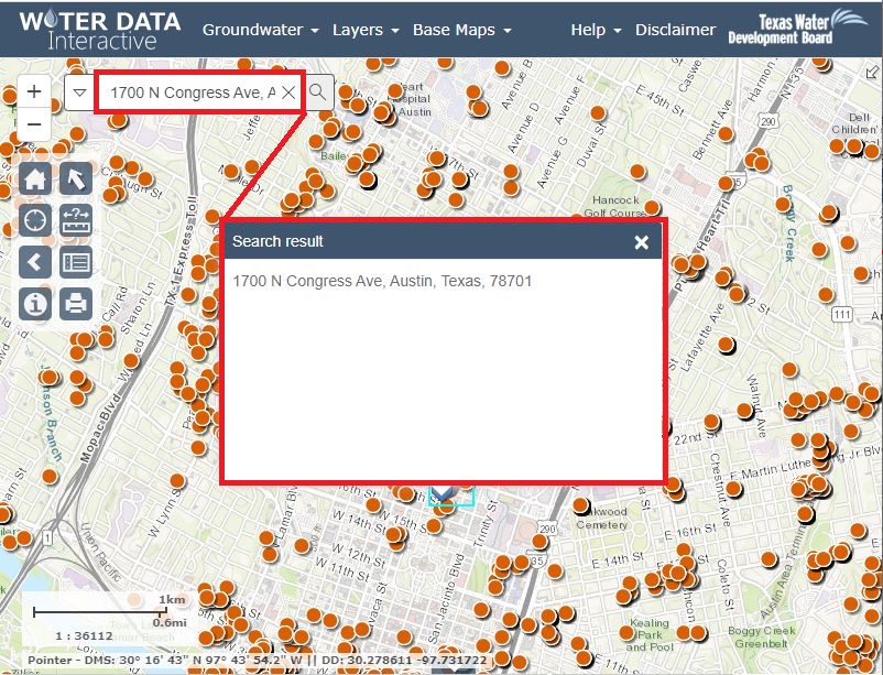
If you have a 911 street address for the well, these well reports can be accessed through the Groundwater Data Viewer
- Enter street address in the search bar in the upper left corner to zoom to that location:
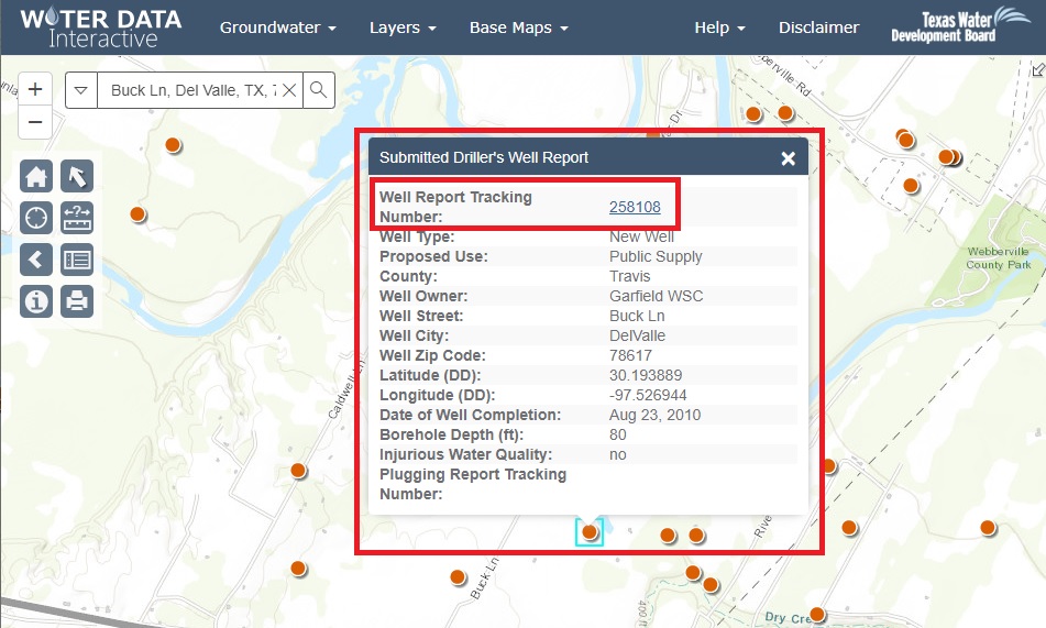
- Each orange dot on the map represents a well location. Click on the dot to bring up a table of information about the well (see below).
- Click on the well report tracking number to open the state of Texas well report for that well.
- If you are unable to locate your well report in the Groundwater Data Viewer, you may want to try searching the Submitted Drillers Reports (SDR) Database webpage. Sometimes the coordinates can get entered incorrectly and well reports may not plot in the right location on the map. See the section Locate a well report by information other than location (Owner, Driller, County, Date Drilled) for instructions on how to search using the SDR Database reports.
- If you are unable to locate your well report in either the Groundwater Data Viewer or the Submitted Drillers Report Database, and it was drilled between 2003 and 2005, it's possible a paper copy was sent to the TCEQ and could be contained in the TCEQ Water Well Report Viewer. See the section Find a well report for a well drilled prior to 2003 for instructions on how to find well reports on the Water Well Report viewer.
Locate well report by information other than location (Owner, Driller, County, Date Drilled)
The Submitted Drillers Reports (SDR) Database webpage allows users to select or enter certain information to obtain well records for specific criteria. For example, the Well Reports Advanced Search allows users to search by owner name, street address, driller name, or within a certain drill date period.
We recommend the "less is more" approach when entering text in the search fields. The search will look for exactly what was entered, so if Congress Avenue is entered, and the driller entered it as Congress Ave, that report will not show up in results. A better approach would be to simply enter the street name, Congress.
If you are unable to locate your well report in either the Groundwater Data Viewer or the Submitted Drillers Report Database, and it was drilled between 2003 and 2005, it's possible a paper copy was sent to the TCEQ and could be contained in the Water Well Report Viewer. See the section Find a well report for a well drilled prior to 2003 for instructions on how to find well reports on the Water Well Report viewer.
Find a well report for a well drilled prior to 2003:
Copies of these well reports can be accessed from the TCEQ Water Well Report Viewer.
To view reports in that database:
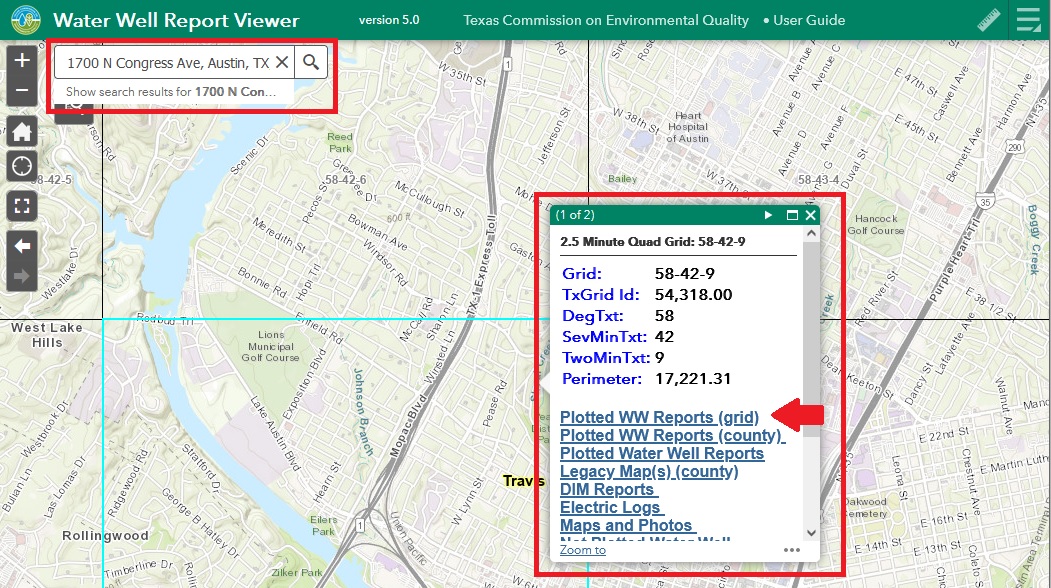
- Enter the street address in the upper left corner of the map, and the map will zoom to that location.
- Click anywhere in the map and a menu will pop up.
- Click on �Plotted WW Reports (grid)�.
- Click on the link in the Grid Num column. This will download a PDF file of those reports.
Note: The Report Box Type column will describe whether the link contains reports or maps. If it says "Reports and standard size maps" it will contain well reports. If it says "Oversized maps" it will only contain maps.
Also, depending on the number of reports for that grid, there may be one to several links in the Grid Num column. Each link will download a separate set of reports.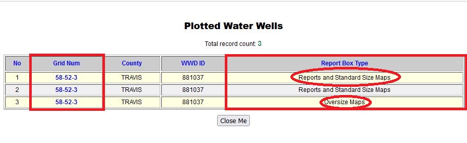
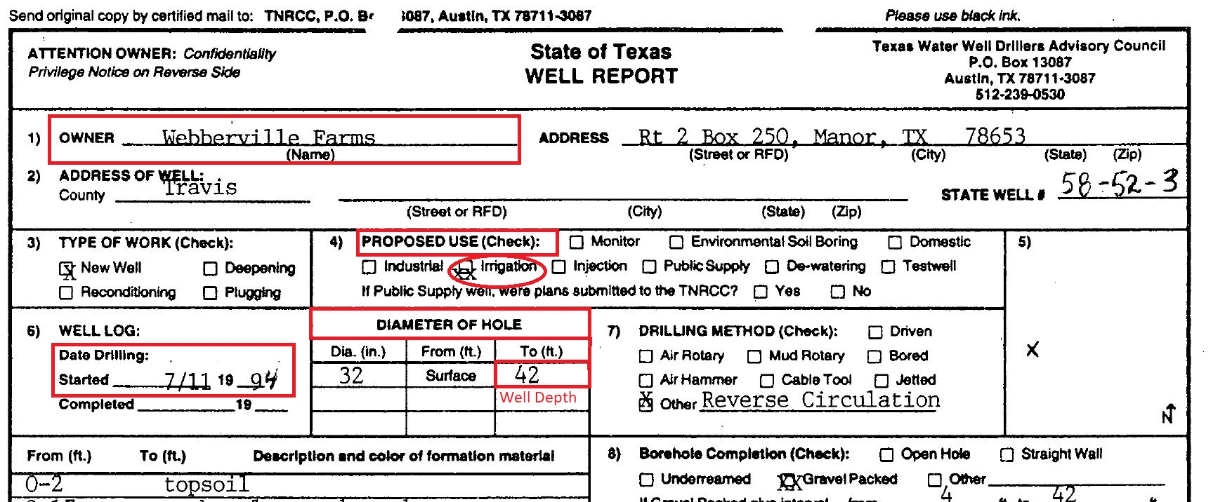
In the above photo, the link in the Grid Num box in the first two rows will open a PDF of well reports. The link in the 3rd row will open a PDF of maps only. - Most of the information needed to determine if a well report in the Water Well Report Viewer goes with your well (owner name, well address, date drilled, well depth, proposed use) will be located in the first few fields of the report.
- If you know the name of the person who had the well drilled, you can compare that with the Owner listed on the well report. This is usually the first field in the report.
- If you know when the well was drilled, you can compare that with the information listed in the Date Drilled, box.
- If you know the intended use of the well, such as if it was drilled to supply a house (domestic) or for livestock or irrigation, you can compare that with the information in the Proposed Use section of the report.
- If you know how deep the well is, you can compare that with the information listed in the Diameter of Hole box.
- You can also check the Well Address box, but on older well reports it's common to either have a Route and Box address, or sometimes even just a description such as "3 mi NW of Manor".
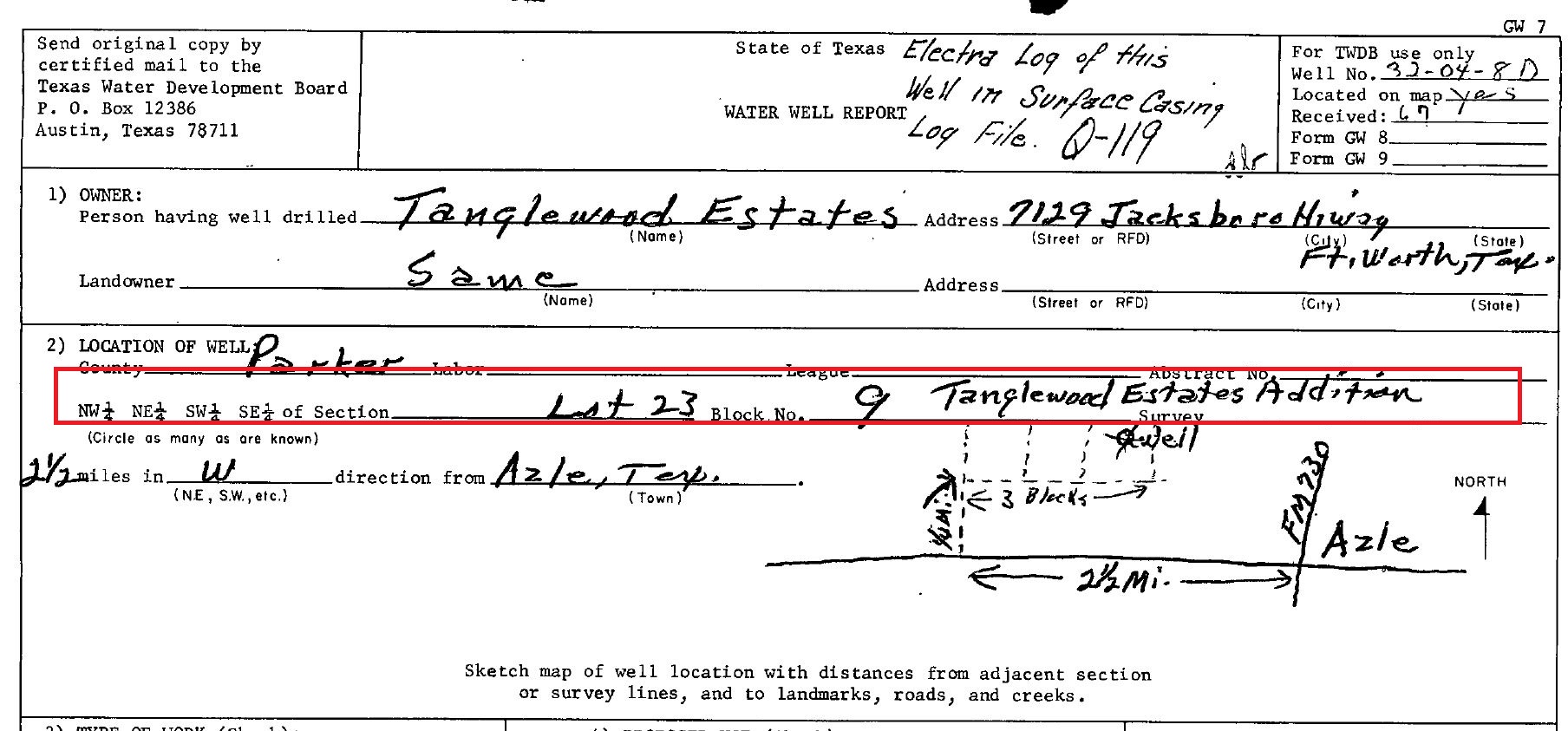
- Some of the older well reports may not have the well location�s street address, but instead may have the property�s legal description (e.g. Lot 23, Blk 9, Tanglewood Estates Addition). The legal description for a property may be obtained from the county�s appraisal district.
- The map�s User Guide has more information on how to best use the water well report viewer.
Other Resources:
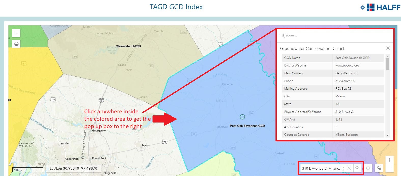
Groundwater conservation districts (GCD): Several counties in Texas have a GCD which collects information about wells within their jurisdiction, including water well reports. To find if a location falls within a GCD's boundary, you can use the Texas Alliance of Groundwater District's GCD Index. Search for an address in the lower right corner of the map. Click on a colored part of the map to reveal information about that district.
Texas Department of Licensing and Regulation Water Well Drillers and Pump Installers Program: A good resource for information about water well drillers, pump installers, laws regarding water wells, and other technical information about water wells.
Texas Well Owners Network: Offers information and trainings on owning a private water well. Their Fact Sheets contain a lot of useful information about water wells.
The Groundwater Technical Assistance Department is always available for questions about locating well reports. Email us at GroundwaterData@twdb.texas.gov.