Woodbine Aquifercross-section
Aquifer Facts
- Aquifer type: confined and unconfined
- Area of outcrop: 1,561 square miles
- Area of subsurface: 5,784 square miles
- Proportion of aquifer with groundwater conservation districts: 73 percent
- Number of counties containing the aquifer: 17
Summary
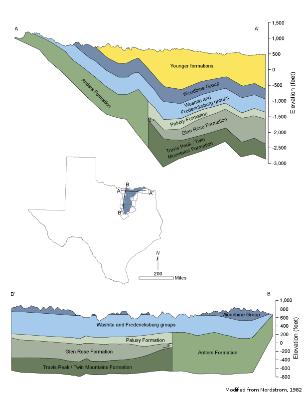
The Woodbine Aquifer is a minor aquifer located in northeast Texas. The aquifer overlies the Trinity Aquifer and consists of sandstone interbedded with shale and clay that form three distinct water-bearing zones. The Woodbine Aquifer reaches 600 feet in thickness in subsurface areas, and freshwater saturated thickness averages about 160 feet. Water quality and yield vary with the depth of the aquifer.
The lower zones of the aquifer typically yield the most water, whereas the upper zone yields limited water that tends to be very high in iron. In general, water to a depth of 1,500 feet is fresh, containing less than 1,000 milligrams per liter of total dissolved solids. Water at depths below 1,500 feet is slightly to moderately saline, containing from 1,000 to 4,000 milligrams per liter of total dissolved solids.
The aquifer provides water for municipal, industrial, domestic, livestock, and small irrigation supplies.
Reports
| ID | Date | Type | Description |
|---|---|---|---|
| Texas Aquifers Study | 12/31/2016 | Legislative Report | Texas Aquifers Study: Groundwater Quantity, Quality, Flow, and Contributions to Surface Water |
| HA-04 | 1/1/1996 | Hydrologic atlas | Water Quality in the Woodbine Aquifer (in sections) |
| B-6310 | 12/1/1973 | Groundwater bulletin | Reconnaissance Investigation of the Ground-Water Resources of the Brazos River Basin, Texas |
| R-160 | 11/1/1972 | TWDB numbered report | Ground-Water Resources of Navarro County, Texas |
| R-269 | 4/1/1982 | TWDB numbered report | Occurrence, Availability and Chemical Quality of Ground Water in the Cretaceous Aquifers of North-Central Texas, Volumes 1 & 2 |
| R-195 | 11/1/1975 | TWDB numbered report | Ground-Water Resources of Part of Central Texas with Emphasis on the Antlers and Travis Peak Formations, Volumes 1 & 2 |
| R-319 | 1/1/1990 | TWDB numbered report | Evaluation of Water Resources in Part of Central Texas |
| R-349 | 11/1/1999 | TWDB numbered report | Updated Evaluation of Water Resources in Part of North-Central Texas, 1990-1999 |
| R-318 | 1/1/1990 | TWDB numbered report | Evaluation of Water Resources in Part of North-Central Texas |
| GR11-004_MP | 9/26/2011 | GAM run - Management Plan | Management plan information for Prairielands GCD |
| GR10-034_MP | 10/26/2010 | GAM run - Management Plan | Management plan information for North Texas GCD |
| GR10-032_MP | 9/29/2010 | GAM run - Management Plan | Management plan information for Red River GCD |
| GR09-022_MP | 11/20/2009 | GAM run - Management Plan | Management plan information for Upper Trinity GCD |
| GR09-021_MP | 7/31/2009 | GAM run - Management Plan | Management plan information for Neches & Trinity Valleys GCD |
| GR08-089_MP | 5/20/2009 | GAM run - Management Plan | Management plan information for Lost Pines GCD |
| GR08-072_MP | 10/3/2008 | GAM run - Management Plan | Management plan information for Middle Trinity GCD |
| GR08-071_MP | 10/3/2008 | GAM run - Management Plan | Management plan information for Neches & Trinity Valleys GCD |
| GR08-069_MP | 9/10/2008 | GAM run - Management Plan | Management plan information for McLennan County GCD |
| GR08-066 | 5/17/2010 | GAM run | Predictive simulation for the Woodbine and Trinity aquifers in Groundwater Management Area 8 |
| GR08-065_MP | 8/22/2008 | GAM run - Management Plan | Management plan information for Northern Trinity GCD |
| GR08-064 | 5/17/2010 | GAM run | Predictive simulation for the Woodbine and Trinity aquifers in Groundwater Management Area 8 |
| CR-1004831116 | 7/11/2012 | Contract report | Aquifer Test and Related Well Information from Public Water Supply Wells in Groundwater Management Area 8 |
| R-380 | 7/1/2011 | TWDB numbered report | Aquifers of Texas |
| CR-1004831114 | 8/9/2012 | Contract report | Ground Water Recharge Model: Calibration and Validation for Remotely-Sensed Dual Coefficient (RDC) GMA8 ET Estimation |
| GT13-031_TERS | 1/15/2014 | GAM task - Total Estimated Recoverable Storage | Total Estimated Recoverable Storage for aquifers in Groundwater Management Area 8 |
| GR14-003_MP | 8/29/2014 | GAM run - Management Plan | Management plan data for Southern Trinity GCD |
| GR14-015_MP | 2/9/2015 | GAM run - Management Plan | Management Plan data for Southern Trinity GCD |
| GR14-001_MP | 3/31/2015 | GAM run - Management Plan | Management plan data for Northern Trinity GCD |
| GR16-004_MP | 5/16/2016 | GAM run - Management Plan | Management plan information for North Texas GCD |
| GR16-005_MP | 5/16/2016 | GAM run - Management Plan | Management plan information for Red River GCD |
| GR-_MP | 8/17/2016 | GAM run - Management Plan | Management plan information for Prairielands GCD |
| GR16-007_MP | 8/17/2016 | GAM run - Management Plan | Management plan information for Prairielands GCD |
| GR18-017_MP | 3/6/2019 | GAM run - Management Plan | Management plan information for Neches and Trinity Valleys GCD |
| GR19-016_MP | 10/24/2019 | GAM run - Management Plan | Management plan information for Southern Trinity GCD |
| GR21-001_MP | 1/14/2022 | GAM run - Management Plan | Management plan information for North Texas GCD |
| GR21-002_MP | 1/24/2022 | GAM run - Management Plan | Management plan information for Red River GCD |
| GR23-025_MP | 12/21/2023 | GAM run - Management Plan | Management plan information for Prairielands GCD |