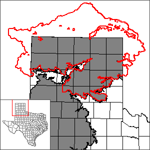
Northern portion of the Ogallala Aquifer Groundwater Availability Model (GAM)
This groundwater availability model has been superseded by the High Plains Aquifer System Groundwater Availability Model, which includes the Ogallala, Edwards-Trinity (High Plains), and Dockum aquifers. However, model users interested in details about the development of the northern portion of the Ogallala Aquifer Groundwater Availability Model should still refer to the GAM reports listed below.
 The Panhandle Regional Water Planning Group contracted the Texas Bureau of Economic Geology (TBEG) to develop a new numerical model for the aquifer. Along with the Ogallala Aquifer, the Rita Blanca Aquifer is also included in this model. A final report and model were delivered in 2001. Revisions to this model include the 2004 and 2010 models documented below. Please see the next section for details.
In July 2012, the Texas Water Development Board (TWDB) contracted with INTERA, Inc. to develop a groundwater availability model (GAM) for the High Plains Aquifer System. The project was completed and delivered in 2015. The new model and report can be found on the High Plains Aquifer System Groundwater Availability Model page.
Model Report
"Northern Ogallala GAM Update To Support 2011 [Region A] Water Plan."
Model Files and Associated Data
The northern portion of the Ogallala Aquifer Groundwater Availability Model has been incorporated into the High Plains Aquifer System Groundwater Availability Model. See the High Plains Aquifer System Groundwater Availability Model page for model files.
Model Grid
Model grid cells are geographically assigned to counties, groundwater conservation districts, river basins, groundwater management areas, and regional water planning areas within the model study area using a centroid based approach. The model grid is available in ESRI® shapefile format and comma-delimited text file.
See the High Plains Aquifer System Groundwater Availability Model page for the model grid.
Stakeholder Advisory Forums (SAF)
Send us an email if you would like to receive SAF notifications.
| ID | Date | Location |
|---|---|---|
| SAF 2 | 4/5/2004 | Amarillo, Texas - Panhandle Regional Planning Commission (415 West Eight Avenue) |
| SAF 1 | 12/18/2003 | Amarillo, Texas - Panhandle Regional Planning Commission (415 West Eight Avenue) |
Other Resources
Please see the Ogallala and Rita Blanca aquifer pages for other reports and publications.
For model runs see the GMA 1 page.