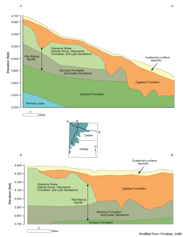
Rita Blanca Aquifercross-section
Aquifer Facts
- Aquifer type: mostly confined
- Area of aquifer: 918 square miles
- Proportion of aquifer with groundwater conservation districts: 99 percent
- Number of counties containing the aquifer: 2
Summary
The Rita Blanca Aquifer is a minor aquifer that underlies the Ogallala Aquifer in the northwest corner of the Texas Panhandle and extends into New Mexico and Oklahoma. Groundwater occurs in the coarse-grained sand and gravel layers of the Lytle and Dakota formations as well as in the Exeter Sandstone and the Morrison Formation. The thickness of the aquifer is as much as 250 feet, and freshwater saturated thickness averages about 180 feet. The Rita Blanca is part of the High Plains Aquifer System and is hydraulically connected to the Ogallala Aquifer and the underlying Dockum Aquifer in some areas. The total thickness of water-yielding rocks in these places is much greater.
Water in the aquifer is usually fresh, containing less than 1,000 milligrams per liter of total dissolved solids, but very hard; however, some parts of the aquifer produce water that is slightly saline, containing more than 1,000 milligrams per liter of total dissolved solids. Primary and secondary maximum contaminant level exceedances for gross alpha radiation, arsenic, fluoride, and total dissolved solids occur in a small percentage of wells completed in the Rita Blanca.
Irrigation accounts for most of the groundwater use from this aquifer, Texline being the only community that uses the aquifer for municipal water supply.
Reports
| ID | Date | Type | Description |
|---|---|---|---|
| Texas Aquifers Study | 12/31/2016 | Legislative Report | Texas Aquifers Study: Groundwater Quantity, Quality, Flow, and Contributions to Surface Water |
| R-315 | 11/1/1989 | TWDB numbered report | Evaluation of Ground-Water Resources in Dallam County, Texas |
| GR12-003_MP | 7/2/2012 | GAM run - Management Plan | Management plan data for North Plains GCD |
| R-380 | 7/1/2011 | TWDB numbered report | Aquifers of Texas |
| GR12-003_MP_Ver2 | 9/17/2012 | GAM run - Management Plan | Revised management plan data for North Plains GCD |
| GT15-006_TERS | 12/17/2015 | GAM task - Total Estimated Recoverable Storage | Total Estimated Recoverable Storage for aquifers in Groundwater Management Area 1 |
| GR17-008_MP | 4/7/2017 | GAM run - Management Plan | Management plan information for North Plains GCD |
| GR22-015_MP | 1/13/2023 | GAM run - Management Plan | Management plan information for North Plains GCD |
| GR21-007_MAG | 2/28/2023 | GAM run - MAG | Modeled available groundwater estimates for the High Plains Aquifer System in Groundwater Management Area 1 |