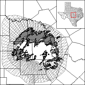
Llano Uplift Aquifer System Groundwater Availability Model (GAM)
 The Texas Water Development Board has developed a groundwater availability model for the Llano Uplift Aquifer System (Ellenburger-San Saba, Hickory, and Marble Falls). The numerical model report is now available.
Current GAM
Numerical Model Report
"Numerical Model Report: Minor Aquifers in Llano Uplift Region of Texas."
Conceptual Model Report
"Conceptual Model Report: Minor Aquifers in Llano Uplift Region of Texas."
Please see the GAM files download page for the geodatabase containing the source data files.
Other Pertinent Studies
"Llano Uplift Aquifer System − Structure and Stratigraphy."
Model Files and Associated Data
Please see the GAM files download page for the current model files and associated data.
Aquifer data is only available as a package for the entire model area and requires GIS software for processing. Please see the GAM files download page for aquifer data.
Stakeholder Advisory Forums (SAF)
| ID | Date | Location |
|---|---|---|
| SAF 1 | 7/17/2012 | Fredericksburg, Texas - Hill Country University Center |
| SAF 2 | 9/30/2014 | Fredericksburg, Texas - Hill Country University Center |
| SAF 3 | 3/16/2016 | Fredericksburg, Texas - Hill Country University Center |
Other Resources
Please see the Ellenburger-San Saba, Hickory, and Marble Falls, aquifer pages, and the Research Projects in Support of Groundwater Models page for other reports and publications.