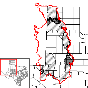
Dockum Aquifer Alternative Groundwater Flow Model
Note: this alternative groundwater flow model has been superseded by the High Plains Aquifer System GAM, where the Dockum Aquifer is represented by layers 3 and 4.
The original groundwater availability model for the Dockum Aquifer was found to be ineffective for use in predictive simulations. This original model for the Dockum Aquifer could not appropriately perform predictive simulations because it 1) used a layer to represent units overlying the Dockum Aquifer that was controlled by general-head boundary conditions, which inhibited translation of inactive cells in the models representing the overlying units to the Dockum Aquifer model, and 2) contained discrepancies in the layer elevations between the Dockum Aquifer model and the models representing the overlying units, which made using head elevations in predictive simulations a challenge.
The changes made include removal of the overlying layer representing younger units, transfer of the general-head boundary conditions directly to the top of the Dockum Aquifer cells, use of historical saturated thickness from the northern and southern Ogallala Aquifer groundwater availability models (as opposed to water-level elevation), shortening the historical period of the model to only the calibration period, and recalibration of the model using a parameter estimation procedure (PEST) and trial-and-error.
Model Report
"Modification and Recalibration of the Groundwater Availability Model of the Dockum Aquifer."
Model Files
Please contact the GAM Section (512-936-0871) for a copy of model files.
Other Resources
Please see the Dockum Aquifer and High Plains Aquifer System GAM pages for other reports and publications.
For model runs see the GMA 1, GMA 2, GMA 3, GMA 6, and GMA 7 pages.