Nacatoch Aquifercross-section
Aquifer Facts
- Aquifer type: confined and unconfined
- Area of outcrop: 891 square miles
- Area of subsurface: 939 square miles
- Proportion of aquifer with groundwater conservation districts: 0.5 percent
- Number of counties containing the aquifer: 15
Summary
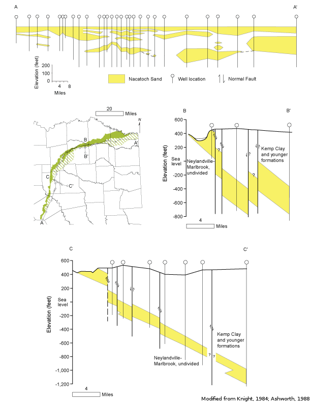
The Nacatoch Aquifer is a minor aquifer that occurs in a narrow band across northeast Texas. The aquifer consists of the Nacatoch Sand, composed of sequences of sandstone separated by impermeable layers of mudstone or clay. These sandstones are marine in origin, coarsen upward, and are laterally discontinuous. The number of sand layers varies throughout the aquifer�s extent, and the thickness of individual sand units ranges from more than 100 feet in the north to less than 20 feet to the south. Thickness of intervening mudstone units similarly ranges from more than 100 feet to only a few feet. Freshwater saturated thickness averages about 50 feet. The aquifer also includes a hydraulically connected cover of alluvium that is as much as 80 feet thick along major drainages. Groundwater in this aquifer is usually under artesian conditions except in shallow wells where the Nacatoch Formation crops out and water table conditions exist. The Mexia-Talco Fault Zone generally delineates the subsurface limit of the aquifer.
The groundwater in the aquifer is typically alkaline, high in sodium bicarbonate, and soft. Total dissolved solids in the subsurface increase and are significantly higher south of the Mexia-Talco Fault Zone, where the water contains between 1,000 and 3,000 milligrams per liter of total dissolved solids.
Water from the aquifer is extensively used for domestic and livestock purposes.
Reports
| ID | Date | Type | Description |
|---|---|---|---|
| Texas Aquifers Study | 12/31/2016 | Legislative Report | Texas Aquifers Study: Groundwater Quantity, Quality, Flow, and Contributions to Surface Water |
| R-160 | 11/1/1972 | TWDB numbered report | Ground-Water Resources of Navarro County, Texas |
| R-269 | 4/1/1982 | TWDB numbered report | Occurrence, Availability and Chemical Quality of Ground Water in the Cretaceous Aquifers of North-Central Texas, Volumes 1 & 2 |
| R-305 | 4/1/1988 | TWDB numbered report | Ground-Water Resources of the Nacatoch Aquifer |
| R-349 | 11/1/1999 | TWDB numbered report | Updated Evaluation of Water Resources in Part of North-Central Texas, 1990-1999 |
| R-318 | 1/1/1990 | TWDB numbered report | Evaluation of Water Resources in Part of North-Central Texas |
| GR09-021_MP | 7/31/2009 | GAM run - Management Plan | Management plan information for Neches & Trinity Valleys GCD |
| GR10-006 | 7/30/2012 | GAM run | Predictive simulations for the Nacatoch Aquifer in Groundwater Management Area 8 |
| CR-1004831116 | 7/11/2012 | Contract report | Aquifer Test and Related Well Information from Public Water Supply Wells in Groundwater Management Area 8 |
| R-380 | 7/1/2011 | TWDB numbered report | Aquifers of Texas |
| CR-1004831114 | 8/9/2012 | Contract report | Ground Water Recharge Model: Calibration and Validation for Remotely-Sensed Dual Coefficient (RDC) GMA8 ET Estimation |
| GR13-013_MP | 7/3/2013 | GAM run - Management Plan | Management plan data for Neches & Trinity Valleys GCD |
| GT13-031_TERS | 1/15/2014 | GAM task - Total Estimated Recoverable Storage | Total Estimated Recoverable Storage for aquifers in Groundwater Management Area 8 |
| GT13-034_TERS | 4/2/2014 | GAM task - Total Estimated Recoverable Storage | Total Estimated Recoverable Storage for aquifers in Groundwater Management Area 11 |
| GR18-017_MP | 3/6/2019 | GAM run - Management Plan | Management plan information for Neches and Trinity Valleys GCD |
| GR23-025_MP | 12/21/2023 | GAM run - Management Plan | Management plan information for Prairielands GCD |
| GR24-002_MP | 02/29/2024 | GAM run - Management Plan | Management plan information for Neches & Trinity Valleys GCD |