Lipan Aquifercross-section
Aquifer Facts
- Aquifer type: confined and unconfined
- Area of outcrop: 1,571 square miles
- Area of subsurface: 424 square miles
- Proportion of aquifer with groundwater conservation districts: 85 percent
- Number of counties containing the aquifer: 8
Summary
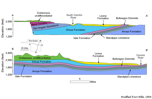
The Lipan Aquifer is a minor aquifer found in parts of Coke, Concho, Glasscock, Irion, Runnels, Schleicher, Sterling, and Tom Green counties in west central Texas. The aquifer includes water bearing alluvium and the up-dip portions of older, underlying strata. The alluvium includes as much as 125 feet of saturated sediments of the Quaternary Leona Formation. These deposits consist mostly of gravels and conglomerates cemented with sandy lime and layers of clay. The formation generally fines upward with conglomerates existing mainly in locations of thicker alluvium. The underlying strata include the San Angelo Sandstone of the Pease River Group and the Choza Formation, Bullwagon Dolomite, Vale Formation, Standpipe Limestone, and Arroyo Formation of the Clear Fork Group. These units are predominantly limestones and shales. Groundwater in the alluvial deposits and the upper parts of the older rocks is hydraulically connected, and most wells in the area are completed in both units. Groundwater flow in the Lipan Aquifer does not appear to be structurally controlled. Higher production wells appear to correspond to alluvial deposits overlying the Choza, Bullwagon, and Vale formations. In these areas, thick alluvial deposits with conglomerates lie near the contact with the Permian System formations.
Groundwater in the alluvium ranges from fresh to slightly saline, containing between 350 and 3,000 milligrams per liter of total dissolved solids, and is very hard. Water in the underlying parts of the Choza Formation and Bullwagon Dolomite tends to be moderately saline with total dissolved solids in excess of 3,000 milligrams per liter. The central region of the aquifer has a high probability of exceeding the maximum contaminant level for total dissolved solids. The eastern portion of the aquifer has the highest probability of exceeding the maximum contaminant level for nitrate.
The aquifer is primarily used for irrigation but also supports livestock and municipal, domestic, and manufacturing uses. Because of drought and heavy irrigation pumping in the late 1990s, water levels decreased significantly in some areas, and the aquifer could not be pumped through the entire irrigation season. In other areas, however, the aquifer could be pumped, but only at a reduced rate.
Reports
| ID | Date | Type | Description |
|---|---|---|---|
| Texas Aquifers Study | 12/31/2016 | Legislative Report | Texas Aquifers Study: Groundwater Quantity, Quality, Flow, and Contributions to Surface Water |
| R-360 | 2/9/2004 | TWDB numbered report | Conference Proceedings: Aquifers of the Edwards Plateau |
| R-146 | 4/1/1972 | TWDB numbered report | Water Well and Ground-Water Chemical Analysis Data, Irion County, Texas |
| R-166 | 3/1/1973 | TWDB numbered report | Ground-Water Resources of Coke County, Texas |
| GR10-026_MP | 8/24/2010 | GAM run - Management Plan | Management plan information for Sterling County UWCD |
| GR10-002 | 9/3/2010 | GAM run | Simulations of current operational practices in the Lipan Aquifer in Groundwater Management Area 7 |
| GR08-051_MP | 7/9/2008 | GAM run - Management Plan | Management plan information for Plateau UWC and Supply District |
| GR08-012_MP | 4/8/2008 | GAM run - Management Plan | Management plan information for Irion County WCD |
| GR08-008_MP | 1/25/2008 | GAM run - Management Plan | Management plan information for Lipan-Kickapoo GCD |
| GR07-039_MP | 4/8/2008 | GAM run - Management Plan | Management plan information for Coke County GCD |
| GR07-013 | 10/5/2007 | GAM run | Predictive simulation for the Lipan Aquifer in Groundwater Management Area 7 |
| GR06-015_MP | 9/1/2011 | GAM run - Management Plan | Management plan information for Lipan Kickapoo WCD |
| GR12-010_MP | 7/2/2012 | GAM run - Management Plan | Management plan data for Lipan-Kickapoo WCD |
| R-380 | 7/1/2011 | TWDB numbered report | Aquifers of Texas |
| GR12-019_MP | 11/16/2012 | GAM run - Management Plan | Management plan data for Coke County UWCD |
| GR12-017_MP | 11/16/2012 | GAM run - Management Plan | Management plan data for Irion County WCD |
| GR13-009_MP | 7/17/2013 | GAM run - Management Plan | Management Plan Information For Plateau UWCD and SD |
| GT13-030_TERS | 10/2/2013 | GAM task - Total Estimated Recoverable Storage | Total Estimated Recoverable Storage for aquifers in Groundwater Management Area 7 |
| GR17-012_MP | 3/28/2017 | GAM run - Management Plan | Management plan information for Sterling County UWCD |
| GR17-005_MP | 5/26/2017 | GAM run - Management Plan | Management plan information for Lipan-Kickapoo Water Conservation District |
| GR17-014_MP | 6/1/2018 | GAM run - Management Plan | Management plan information for Coke County UWCD |
| GR22-013_MP | 11/8/2022 | GAM run - Management Plan | Management plan information for Lipan-Kickapoo WCD |
| GR22-014_MP | 1/23/2023 | GAM run - Management Plan | Management plan information for Irion County WCD |
| GR22-016_MP | 1/31/2023 | GAM run - Management Plan | Management plan information for Sterling County UWCD |
| GR23-021_MP | 09/22/2023 | GAM run - Management Plan | Management plan information for Coke County UWCD |
| GR23-023_MP | 12/14/2023 | GAM run - Management Plan | Management plan information for Plateau Underground Water Conservation & Supply District |