Igneous Aquifercross-section
Aquifer Facts
- Aquifer type: unconfined
- Area of aquifer: 6,075 square miles
- Proportion of aquifer with groundwater conservation districts: 100 percent
- Number of counties containing the aquifer: 6
Summary
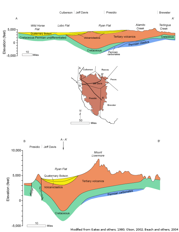
The Igneous Aquifer is a minor aquifer located in Far West Texas. The aquifer consists of volcanic rocks made up of a complex series of welded pyroclastic rock, lava, and volcaniclastic sediments and includes more than 40 different named units as much as 6,000 feet thick. Freshwater saturated thickness averages about 1,800 feet. The best water bearing zones are found in igneous rocks with primary porosity and permeability, such as vesicular basalts, interflow zones in lava successions, sandstone, conglomerate, and breccia. Faulting and fracturing enhance aquifer productivity in less permeable rock units.
Water in the Igneous Aquifer is fresh and contains less than 1,000 milligrams per liter of total dissolved solids. Groundwater from some wells contains elevated levels of silica and fluoride, as a result of weathering of the igneous rock that makes up the aquifer. Groundwater in a few wells exceeds maximum contaminant levels for arsenic, fluoride, and gross alpha radiation.
Water is primarily used to meet municipal needs for the cities of Alpine, Fort Davis, and Marfa, as well as some agricultural needs.
Reports
| ID | Date | Type | Description |
|---|---|---|---|
| Texas Aquifers Study | 12/31/2016 | Legislative Report | Texas Aquifers Study: Groundwater Quantity, Quality, Flow, and Contributions to Surface Water |
| R-356 | 12/1/2001 | TWDB numbered report | Aquifers of West Texas |
| R-016 | 2/1/1966 | TWDB numbered report | Water-Level Data from Observation Wells in Culberson, Jeff Davis, Presidio, and Brewster Counties, Texas |
| GT10-028 | 7/29/2010 | GAM task | Predictive simulations for the Igneous and West Texas Bolsons aquifers in Groundwater Management Area 4 |
| GT10-026 | 6/24/2010 | GAM task | Predictive simulation for the Igneous and West Texas Bolsons aquifers in Groundwater Management Area 4 |
| GR10-003 | 6/29/2010 | GAM run | Predictive simulations for the Igneous and West Texas Bolsons aquifers in Groundwater Management Area 4 |
| GR09-025 | 1/11/2011 | GAM run | Predictive simulation for the Igneous and West Texas Bolsons aquifers in Groundwater Management Area 4 |
| GR08-088_MP | 3/17/2009 | GAM run - Management Plan | Management plan information for Presidio County UWCD |
| GR08-029_MP | 5/28/2008 | GAM run - Management Plan | Management plan information for Jeff Davis County UWCD |
| GR08-024 | 12/19/2008 | GAM run | Predictive simulations for the Igneous and West Texas Bolsons aquifers in Groundwater Management Area 4 |
| GR07-008_MP | 4/26/2007 | GAM run - Management Plan | Management plan information for Brewster County GCD |
| GR06-032 | 5/2/2007 | GAM run | Predictive simulation for the Igneous and West Texas Bolsons aquifers in Groundwater Management Area 4 |
| GR06-017 | 7/18/2006 | GAM run | Predictive simulation for the Igneous and West Texas Bolsons aquifers in Groundwater Management Area 4 |
| GR06-004 | 3/8/2006 | GAM run | Predictive simulation for the Igneous and West Texas Bolsons aquifers in Jeff Davis and Presidio counties |
| GR06-002_MP | 3/1/2006 | GAM run - Management Plan | Management plan information for Culberson County GCD |
| GR05-040 | 2/7/2006 | GAM run | Predictive simulation for the Igneous and West Texas Bolsons aquifers in Jeff Davis and Presidio counties |
| GR11-018_MP | 1/23/2012 | GAM run - Management Plan | Culberson County GCD Management Plan |
| GR12-023_MP | 8/10/2012 | GAM run - Management Plan | Management plan data for Jeff Davis County UWCD |
| R-380 | 7/1/2011 | TWDB numbered report | Aquifers of Texas |
| GR12-026_MP | 3/21/2013 | GAM run - Management Plan | Management plan data for Presidio County UWCD |
| GT13-027_TERS | 9/19/2013 | GAM task - Total Estimated Recoverable Storage | Total Estimated Recoverable Storage for aquifers in Groundwater Management Area 3 |
| GT13-030_TERS | 10/2/2013 | GAM task - Total Estimated Recoverable Storage | Total Estimated Recoverable Storage for aquifers in Groundwater Management Area 7 |
| GR13-020_MP | 10/7/2013 | GAM run - Management Plan | Management Plan data for Brewster County GCD |
| GT13-028_TERS | 1/15/2014 | GAM task - Total Estimated Recoverable Storage | Total Estimated Recoverable Storage for aquifers in Groundwater Management Area 4 |
| GR19-008_MP | 2/27/2019 | GAM run - Management Plan | Management plan information for Brewster County GCD |
| GR19-007_MP | 3/18/2019 | GAM run - Management Plan | Management plan information for Presidio County UWCD |
| GR23-010_MP | 06/07/2023 | GAM run - Management Plan | Management plan information for Jeff Davis County UWCD |