White River Reservoir (Brazos River Basin)
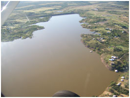 White River Reservoir is located sixteen miles southeast of Crosbyton in Crosby County, on the White River, a tributary of Salt Fork Brazos River which is a tributary of the Brazos River. It is owned and operated by the White River Municipal Water District for water supply and recreational purposes. In 1955 the Texas Board of Water Engineers recommended a lake on the White River to benefit Ralls, Spur, Post, and Crosbyton. After local authorities established the White River Water Control and Improvement District, a Water Right Permit was issued on November 3, 1958. Construction of dam began September 2, 1962 and was finally completed in November of 1963. Deliberate impoundment of water started in October 1963. The earthfill dam is 3,300 feet long and 84 feet high. The top of the dam is at elevation of 2,395 feet above mean sea level. The uncontrolled emergency spillway is located on the right end of the dam and is cut over the natural ground with the crest at an elevation of 2,391.5 feet above mean sea level. The service spillway is a concrete rectangular drop-inlet structure with an
uncontrolled crest at an elevation of 2,372.2 feet above mean sea level. According to the TWDB 1993 survey, the reservoir has a normal capacity of 31,846 acre feet encompassing a surface area of 1,642 acres at its conservation elevation of 2,372.2 feet above mean sea level. The dam controls a drainage area of 172 square miles.
White River Reservoir is located sixteen miles southeast of Crosbyton in Crosby County, on the White River, a tributary of Salt Fork Brazos River which is a tributary of the Brazos River. It is owned and operated by the White River Municipal Water District for water supply and recreational purposes. In 1955 the Texas Board of Water Engineers recommended a lake on the White River to benefit Ralls, Spur, Post, and Crosbyton. After local authorities established the White River Water Control and Improvement District, a Water Right Permit was issued on November 3, 1958. Construction of dam began September 2, 1962 and was finally completed in November of 1963. Deliberate impoundment of water started in October 1963. The earthfill dam is 3,300 feet long and 84 feet high. The top of the dam is at elevation of 2,395 feet above mean sea level. The uncontrolled emergency spillway is located on the right end of the dam and is cut over the natural ground with the crest at an elevation of 2,391.5 feet above mean sea level. The service spillway is a concrete rectangular drop-inlet structure with an
uncontrolled crest at an elevation of 2,372.2 feet above mean sea level. According to the TWDB 1993 survey, the reservoir has a normal capacity of 31,846 acre feet encompassing a surface area of 1,642 acres at its conservation elevation of 2,372.2 feet above mean sea level. The dam controls a drainage area of 172 square miles.