Twin Buttes Reservoir (Colorado River Basin)
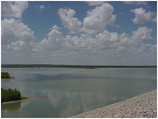 Twin Buttes Reservoir is located eight miles southwest of San Angelo in Tom Green County, on the Middle Concho River, Spring Creek, and the South Concho River which are tributaries to the Colorado River. The project is owned by the United States government and operated by the United States Bureau of Reclamation for flood control, water supply, irrigational, and recreational purposes. Construction began on May 3, 1960, and the dam was completed on February 13, 1963. Deliberate impoundment of water began 1963. The dam consists of two dams, one on the Middle River and the other on South Concho Rivers. They are rolled earthfill embankments of total 42,450 feet long. The top of the dam is at elevation 1,991 feet above mean sea level. Maximum design water surface may reach to 1985 feet above mean sea level. The spillway near the left end of the dam is an uncontrolled ogee-weir type with crest length of 200 feet at elevation 1,969.1 feet above mean sea level. The lakes are connected by channel and have a total conservation storage capacity of 186,203 acre-feet encompassing a total surface area of 9,082 acres at normal elevation of 1,940.2 feet above mean sea level. The drainage area of the reservoir is 3,724 square miles, of which about 1,055 square miles is noncontributing.