Lake Ray Hubbard (Trinity River Basin)
 Lake Ray Hubbard (also known as Rockwall-Forney Dam), formerly Forney Lake, is located just north of Forney about fifteen miles east of Dallas and extends into the counties of Dallas, Kaufman, Collin, and Rockwall, on the East Fork Trinity River, a tributary of the Trinity River. The dam is currently owned by the City of Dallas and operated by Dallas Water Utilities, a not-for-profit department of the City of Dallas for purposes of municipal and industrial water supply, flood control, and recreation.
The Lake was originally named Forney Lake for the nearby town of Forney. After the City of Dallas incorporated the lake, it was renamed after a living person, Ray Hubbard, who presided over the Dallas Parks and Recreation System board from 1943 to 1972. The permit was issued on March 6, 1959 and land was purchased on September 17, 1963 for the reservoir where originally was a small lake named Corder Lake. Construction of dam was started on June 13, 1964 by general contractors, the S. and A. Construction Company and the Markham, Brown and M. C. Winter Construction Company. The Dam was closed in September, 1967 and deliberate impoundment began on December 1, 1968.
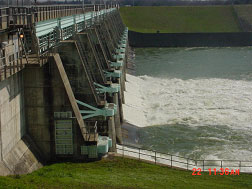
The Dam of a two-mile earth-fill embankment having a top elevation of 450 feet above mean sea level was finally completed on January, 1969. The spillway is concrete ogee weir controlled by 14 tainter gates, each gate is 40 feet wide and 28 feet tall, with a crest of 560 feet net length at an elevation of 409.5 feet above mean sea level. By 1970 the lake reached its maximum designed extent. At the top of the flood control gates or emergence spillway, at an elevation of 437.5 feet above mean sea level, the Lake can store 540,000 acre feet of water encompassing a surface area of 24,000 acres. Lake Ray Hubbard features a lakeside power plant named for its proximity to the lake. The Lake Ray Hubbard Steam Electric Station, a TXU power plant, is a two unit gas/oil fired power plant that has been operating since June 8, 1970 and November 20, 1973. According to the TWDB 2015 survey, at top of the conservation pool, at an elevation of 435.5 feet above mean sea level, the lake measures 20,947 acres of water surface with a storage capacity of 439,559 acre-feet and a maximum depth of about 40 feet. The Dam controls a drainage area of about 1,074 square miles of which 770 square miles are above Lavon Lake.